|
ALERTS (click alert for more info) |
|
|
|
|
None at this time |
|
|
Support SCM by making a single or recurring donation.
|
|
|
Updated: 01:30 PM v2.5
Run Spr to Highland (330): 21 mins 
Highland to Run Spr (330): 21 mins
Big Bear to Run Spr (18): 21 mins
Run Spr to Big Bear (18): 22 mins
Big Bear to Redlands (38): 71 mins 
Redlands to Big Bear (38): 68 mins
Big Bear to Lucerne (18): 37 mins
Lucerne to Big Bear (18): 37 mins
=Light =Moderate  =Heavy Traffic =Heavy Traffic
Road Conditions Page: Click Here |
|
|
Guests: 258, Members: 3 ...
 jeff13811 jeff13811
most ever online: 3772
(Members: 27, Guests: 3745) on Feb 26 23: 07:51am
Members: 9373
Newest member: Rick Bailie |
|
|
|
 SNOWFALL ESTIMATES FOR UPCOMING STORM (4/5 - 4/9) SNOWFALL ESTIMATES FOR UPCOMING STORM (4/5 - 4/9)
|
|
| SCM ALERT🚨 | |
Automated Alert Robot

Joined: Wed Dec 26 2007, 08:50PM
:
Posts: 4237
| SNOWFALL ESTIMATES FOR UPCOMING STORM
A Winter Storm Warning is in effect from 11pm this evening through 5am Thursday for locations above 5500 feet. The NWS has come out with more specific snowfall forecasts for mountain communities (see below):
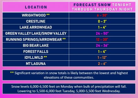
(click image to enlarge)
==============
SCM Automated Alerts
v4.2-1022 AI Provided by SCM and AWS
------------------------------
-------------------------------
Follow the Latest Real-time Information on SCM
Twitter: @bigbearscanner
Facebook: Socalmountains.com
YouTube (Link): [Click Here]
----------------------------------
-
SCM COMMUNITY OF SITES:
socalmountains.com
bigbearscanner.
com
bensweather.com
socaldeserts.co
m
coachellavalley.us
palmspringscan
ner.com
rimtraffic.com
incidents.us | | Back to top | |
| ⚡WX ALERT⚡ |  Sun Apr 05 2020, 07:01PM Sun Apr 05 2020, 07:01PM | |
|
Joined: Sun Aug 14 2016, 09:52PM
:
Posts: 149
|
Ben's Weather Forecast Updated: Sunday, Apr 05 @ 07:00pm [Click Here]
*** WINTER STORM WARNING IN EFFECT TONIGHT THROUGH WEDNESDAY ***
The forecast remains on track for a round of winter-like weather this week as a strong spring storm slowly moves through the region. Low pressure currently off the Northern California coast is pushing a vigorous cold front southward in our direction. Clouds and winds will increase through tonight with a few rain and snow showers developing. Cold and windy as temperatures drop into the lower 30's overnight with southwest winds gusting 20-40mph. This cold front will sweep through our area on Monday bringing snow, possibly heavy at times with gusty winds and freezing temperatures. The snow level will lower to around 6,000 feet with significant snowfall likely through Monday night. Behind the front, low pressure will meander into the area with snow showers continuing Tuesday and Wednesday, some heavy with temperatures generally in the 30's. Winds not as strong with gusts to around 25mph at times. As the low tracks inland to our south then east Wednesday, wrap-around moisture could bring additional heavy snowfall into Thursday before exiting on Friday. This is a fairly cold storm but will have some time to moderate over the Pacific with the snow level bottoming out around 5,000 feet. Total snowfall accumulations of 1-2+ feet look likely this week, with even higher amounts possible in a few areas. With the higher moisture content, this will be an excellent storm for the forest and the lake with minor flooding possible Friday through the weekend as rapid melting creates increased runoff. Fair and warmer weather will return over the weekend with temperatures back up near 60-degrees by Sunday! While highly discouraged, if you must travel this week, due so with extreme caution and carry along extra food, water, and warm clothing in the event you become stranded and always carry chains. With the stay at home order in place, it's a good idea to stay indoors, hunker down and watch the storm from the comfort of your own home, enjoy it and stay safe!
"Halo around the sun or moon, rain or snow soon."
| | Back to top | |
Moderators: Craig ⭐, ©ammy, Lumber Jill, Mtngoat John⭐, firephoto84, Deb Doodah, SCM ALERT🚨, Benny ⭐, Socalmountains Admin, ⚡WX ALERT⚡
|
|
Powered by e107 Forum System 
|
|
|
|
You must be logged in to post comments on this site - please either log in or if you are not registered click here to signup
 SCM ALERT🚨6 hour(s) ago SCM ALERT🚨6 hour(s) ago From the San Bernardino National Forest: Dont let your fun turn into flames! Fireworks are prohibited on public lands #sanbernardinonationalforest [Click Here]As of June 30, 2025 at 08:01AM
cricket6 hour(s) ago Ha ha didn't realize auto check would change the name. Porlalee
cricket6 hour(s) ago Portable they would have the fireworks show if the entire place was falling down. We are getting drift smoke but it is not that bad as of last night. Blue sky's this morning.
Porlalee6 hour(s) ago Planning trip up to Sugarloaf ... are there wildfires near there that could affect July 4 events?? Appreciate any opinions!!!
SCM ALERT🚨18 hour(s) ago [UPDATE] VEGETATION FIRE in DEVORE HEIGHTS Per USFS Cable Fire Holding At 15 Acres. Hose Lay Around The Whole Fire. 30% Contained. Continue To Construct Line. DETAILS: [Click Here]
SCM ALERT🚨18 hour(s) ago From the San Bernardino National Forest: RT @CALFIREBDU: #LakeFire 6.29.25 Evening Update: [Click Here] @SBCOUNTYFIRE @sbcountysheriff @SanBernardinoNF @SBCounty @Silver… As of June 29, 2025 at 07:10PM
mimoo19 hour(s) ago Getting some ash flying around the Woodlands area
SCM ALERT🚨19 hour(s) ago [UPDATE] SMOKE CHECK in HEART BAR CAMPGROUND USFS E316 Has Checked The Area. This Will Be Drift Smoke. MISTAKEN ID. DETAILS: [Click Here]
SCM ALERT🚨19 hour(s) ago From the San Bernardino National Forest:
RT @sbcountysheriff: On June 29, 2025, at 6PM, The evacuation order for the area south of Highway 138 between the 15 Freeway and Highway ha…
As of June 29, 2025 at 06:37PM
SCM ALERT🚨19 hour(s) ago [UPDATE] VEHICLE FIRE in CRESTLINE Fully Involved Vehicle Fire With Trailer. Fire Is Contained To The Vehicle. No Vegetation Involved. CANCEL The Aircraft. DETAILS: [Click Here]
SCM ALERT🚨19 hour(s) ago [CHP DISPATCH] CRESTLINE - VEHICLE FIRE HIGHWAY 18 / LAKE GREGORY DR 6:19PM [5] REPORTING PARTY ADVISE ON RIGHT HAND SHOULDER // CLOSE TO BRUSH [SHARED] 6:19PM [2] ALL PARTYS OUT OF VEHICLE UPDATES: [Click Here]
⚡WX ALERT⚡20 hour(s) ago Just called it a false alarm, mistaken identity, all units returning to quarters. No fire near FF. It's all drift smoke from the Wolf Fire.
⚡WX ALERT⚡20 hour(s) ago Nona, most of that is smoke from the Wolf Fire in Banning. We have south-southwest winds pushing the smoke right at us. The Forest Service has been unable to locate any fires in the area, suspecting drift smoke.
|
|
|