SNOWFALL ESTIMATES FOR UPCOMING STORM (4/5 - 4/9)
SCM ALERT🚨, Sun Apr 05 2020, 06:51PM
SNOWFALL ESTIMATES FOR UPCOMING STORM
A Winter Storm Warning is in effect from 11pm this evening through 5am Thursday for locations above 5500 feet. The NWS has come out with more specific snowfall forecasts for mountain communities (see below):
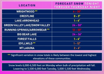
(click image to enlarge)
Re: SNOWFALL ESTIMATES FOR UPCOMING STORM (4/5 - 4/9)
⚡WX ALERT⚡, Sun Apr 05 2020, 07:01PM
Ben's Weather Forecast Updated: Sunday, Apr 05 @ 07:00pm [Click Here]
*** WINTER STORM WARNING IN EFFECT TONIGHT THROUGH WEDNESDAY ***
The forecast remains on track for a round of winter-like weather this week as a strong spring storm slowly moves through the region. Low pressure currently off the Northern California coast is pushing a vigorous cold front southward in our direction. Clouds and winds will increase through tonight with a few rain and snow showers developing. Cold and windy as temperatures drop into the lower 30's overnight with southwest winds gusting 20-40mph. This cold front will sweep through our area on Monday bringing snow, possibly heavy at times with gusty winds and freezing temperatures. The snow level will lower to around 6,000 feet with significant snowfall likely through Monday night. Behind the front, low pressure will meander into the area with snow showers continuing Tuesday and Wednesday, some heavy with temperatures generally in the 30's. Winds not as strong with gusts to around 25mph at times. As the low tracks inland to our south then east Wednesday, wrap-around moisture could bring additional heavy snowfall into Thursday before exiting on Friday. This is a fairly cold storm but will have some time to moderate over the Pacific with the snow level bottoming out around 5,000 feet. Total snowfall accumulations of 1-2+ feet look likely this week, with even higher amounts possible in a few areas. With the higher moisture content, this will be an excellent storm for the forest and the lake with minor flooding possible Friday through the weekend as rapid melting creates increased runoff. Fair and warmer weather will return over the weekend with temperatures back up near 60-degrees by Sunday! While highly discouraged, if you must travel this week, due so with extreme caution and carry along extra food, water, and warm clothing in the event you become stranded and always carry chains. With the stay at home order in place, it's a good idea to stay indoors, hunker down and watch the storm from the comfort of your own home, enjoy it and stay safe!