|
ALERTS (click alert for more info) |
|
|
|
|
None at this time |
|
|
Support SCM by making a single or recurring donation.
|
|
|
Updated: 06:00 PM v2.5
Run Spr to Highland (330): 20 mins 
Highland to Run Spr (330): 19 mins
Big Bear to Run Spr (18): 22 mins
Run Spr to Big Bear (18): 21 mins
Big Bear to Redlands (38): 68 mins
Redlands to Big Bear (38): 65 mins
Big Bear to Lucerne (18): 36 mins
Lucerne to Big Bear (18): 35 mins
=Light  =Moderate =Moderate  =Heavy Traffic =Heavy Traffic
Road Conditions Page: Click Here |
|
|
Guests: 206, Members: 3 ...
 Tman Tman
MrOwl
Metcalf Man
most ever online: 3772
(Members: 27, Guests: 3745) on Feb 26 23: 07:51am
Members: 9375
Newest member: Pln |
|
|
|
 Peter Pan Drive In Peter Pan Drive In
|
|
| GWTWTOO | | Registered Member #1890
Joined: Thu Aug 06 2009, 10:23PM
:
Posts: 20
| Can anyone tell me exactly where this drive in was vis-a-vis what's there now? I would really appreciate it! Does anyone have any photos? I don't seem to be able to locate anywhere. Thanks, | | Back to top | |
| Doug G |  Wed Jul 10 2019, 01:28PM Wed Jul 10 2019, 01:28PM | |
| Registered Member #1586
Joined: Sat Aug 02 2008, 04:04PM
:
Posts: 138
| The drive-was located in what is now the east end of the airport. We lived on Sierra off Greenway in the 50's. The drive-in would let us kids haul over a sleeping bag and walk-in, and the first row or two of speaker kiosks were pretty much reserved for the small-fry walk-in crowd. I watched a few movies there as a kid.
======
Doug G
====== | | Back to top | |
| Shibbergish | | Wed Jul 10 2019, 06:51PM | |
| Registered Member #48183
Joined: Tue Mar 05 2019, 10:01AM
:
Posts: 112
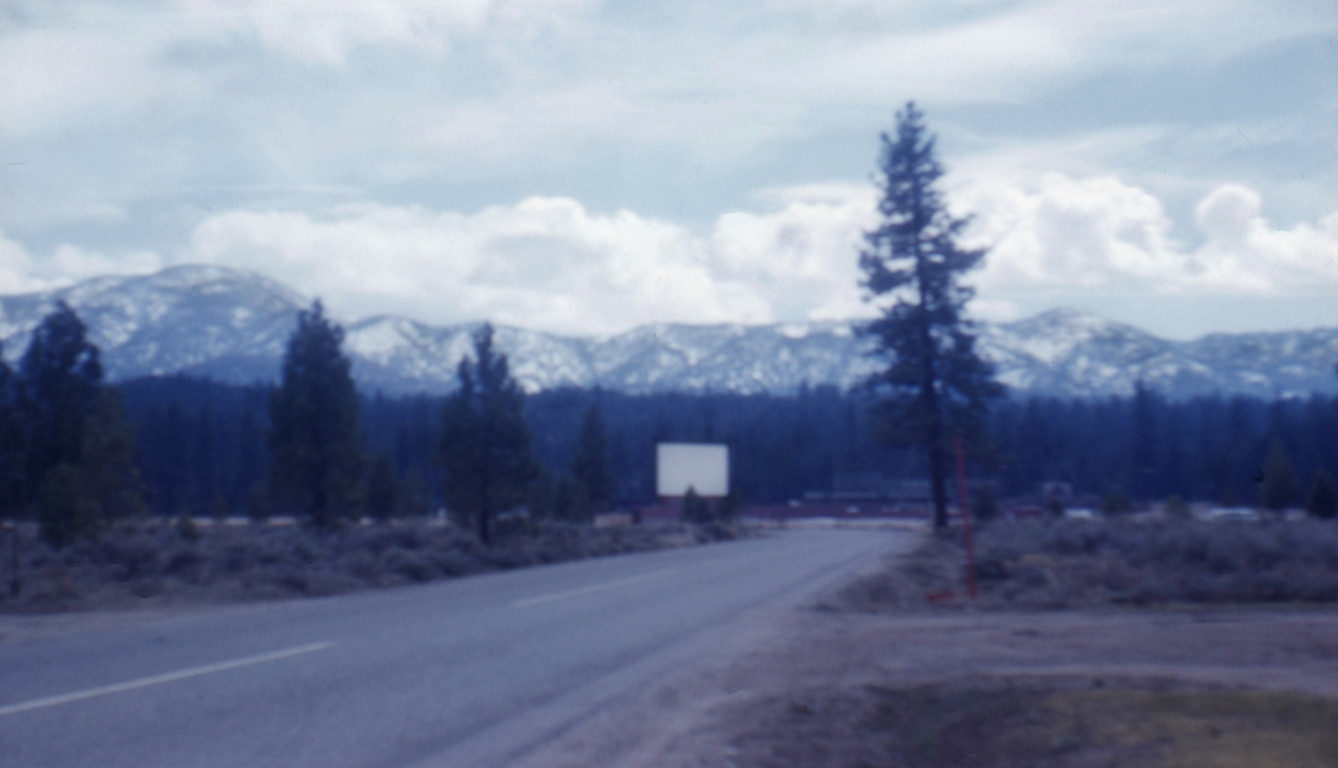
| This awful, fuzzy picture is alleged to have been taken in 1958. The view is looking south from, roughly, the corner of Greenway and Arbor. The Drive-in screen is right in the middle of the picture.
While it was in operation, the Drive-in was bounded on the north by Meadow Lane, the east by Greenway and the west by Sawmill (long gone -- sucked into the County Airport Black Hole). On the south was a little dirt road connecting Greeway with Sawmill. Further south was a drainage channel, then the Peter Pan swimming pool, Lodge and tennis courts. The drive-in is all gone now, paved over and turned into the taxiway and run-up area for runway 26.

| | Back to top | |
| GWTWTOO | | Wed Jul 10 2019, 08:33PM | |
| Registered Member #1890
Joined: Thu Aug 06 2009, 10:23PM
:
Posts: 20
| Wow! Thank you! I so thankful to have any photo of it! | | Back to top | |
| SocalSnowMan | | Thu Jul 25 2019, 07:38AM | |
|
SocalSnowMan
Registered Member #228
Joined: Sun Dec 17 2006, 07:41AM
:
Posts: 3525
| In the early 60's I would grab a blanket and walk down the street with a couple of local residents and we would sneak through a hole in the west fence and watch the movies. One summer we were there so much we saw every weekly showing for about 6 or 7 weeks. | | Back to top | |
Moderators: Craig ⭐, Mtngoat John⭐, SCM ALERT🚨, Benny ⭐, Socalmountains Admin, ⚡WX ALERT⚡
|
|
Powered by e107 Forum System 
|
|
|
|
You must be logged in to post comments on this site - please either log in or if you are not registered click here to signup
 SCM ALERT🚨37 minute(s) ago SCM ALERT🚨37 minute(s) ago [UPDATE] VEGETATION FIRE in LUCERNE VALLEY Baker Fire (Lucerne Valley) - Per Air Attack Firefighters Making Good Progress On This Fire. Cancelling The 2 Outstanding Tankers. DETAILS: [Click Here]
SCM ALERT🚨49 minute(s) ago [INCIDENT DISPATCH] FG /VEGETATION FIRE IN LUCERNE VALLEY - BAKER INCIDENT / POWERLINE RD & BAKER RD LUCERNE VALLEY DETAILS: [Click Here]
SCM ALERT🚨1 hour(s) ago @CALFIREBDU: [New Incident] Vegetation Fire reported Powerline Road x Baker Road, Lucerne Valley. Units responding from @BLMca @SBCOUNTYFIRE @SanBernardinoNF @CALFIREBDU [Click Here]
SCM ALERT🚨2 hour(s) ago [UPDATE] VEGETATION FIRE in HESPERIA Per CalFire -- Air Attack Is Over The Bowen Fire. Reporting One Half An Acre With NO Rate Of Spread. Fire Surrounded By Roads. All Aircraft Released. All AVFPD And SB County Fire Units Released. Air Attack Will Work To Get Some Boots Up To The Fire. DETAILS: [Click Here]
SCM ALERT🚨2 hour(s) ago [UPDATE] VEGETATION FIRE in HESPERIA Air Attack 12 Is In The Area Of This Reported Fire. So For Unable To Locate Anything. Tankers 72 And 73 Are Moving Into The Area Over Lake Arrowhead. Holding The Remainder Of The Aircraft Response. This May Be A False Alarm. DETAILS: [Click Here]
SCM ALERT🚨3 hour(s) ago [UPDATE] VEGETATION FIRE in HESPERIA Ground Resources Still Trying To Make Access To This Fire. Nobody Is On Scene Yet. The Only Report Of Conditions They Have Is From 40KING Helicopter. DETAILS: [Click Here]
SCM ALERT🚨3 hour(s) ago @CALFIREBDU: [New Incident] Vegetation Fire reported in the area of Bowen Ranch Road x Hot Springs Trail, Apple Valley. Units responding from @calfirebdu @SBCOUNTYFIRE @BLMca #BowenFire [Click Here]
Polar 🌌rbit3 hour(s) ago It seems the eagles have survived the last eight years of indigent humans lighting fireworks in their chosen habitat. Let it be.
solargardens6 hour(s) ago He also said that the different harmonics and gunpowder smell may cause distress in wildlife vs the thunder harmonics and ozone.
solargardens6 hour(s) ago I had an wildlife biologist friend tell me that it is the vibrational frequency differences.
BootsNBridles10 hour(s) ago Thunderstorms are natural AND the thunder doesn't rumble for as long. Even so I've observed birds and burros both startling and moving after s particularly loud clap of thunder. I'm guessing other less visible wilds react similarly.
MountainDreamin10 hour(s) ago What do the eagles do during thunderstorms and lightning strikes?
SCM ALERT🚨12 hour(s) ago [CHP DISPATCH] CRESTLINE - CLOSURE OF A ROAD SR138 / OLD MILL RD UPDATES: [Click Here]
|
|
|