Support SCM by making a single or recurring donation.
ROADS AND TRAFFIC
Updated: 06:30 PM v2.5 Run Spr to Highland (330): 19 mins Highland to Run Spr (330): 21 mins Big Bear to Run Spr (18): 21 mins Run Spr to Big Bear (18): 21 mins Big Bear to Redlands (38): 66 mins Redlands to Big Bear (38): 64 mins Big Bear to Lucerne (18): 34 mins Lucerne to Big Bear (18): 34 mins =Light =Moderate =Heavy Traffic Road Conditions Page: Click Here
Registered Member #4 Joined: Sat Aug 19 2006, 06:01PM : Posts: 13166
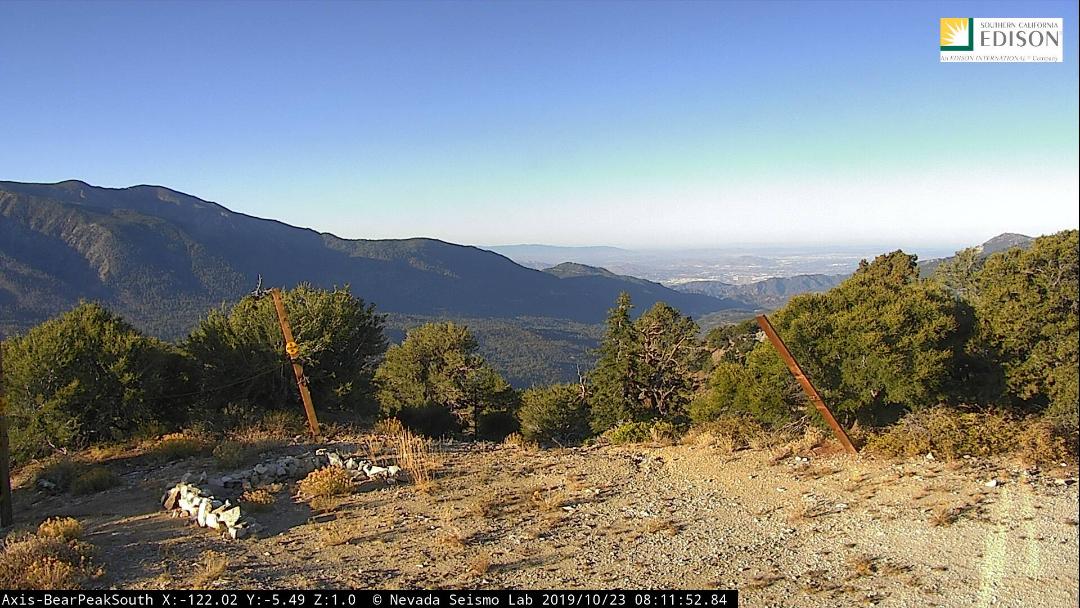
AlertWildfire.org and Big Bear Mountain Resorts have partnered to bring several fire cameras to the Big Bear area. These cameras act like virtual fire lookouts in that they're located on high places with great views of the surrounding area. The cameras can be panned, tilted and zoomed to locations to look for smoke from fires. The first Big Bear camera went live this morning: [Click Here] It's the very first camera in the thumbnail view of cameras: Bear Peak South.
For those not familiar with AlertWildfire cameras, if you click on the image above the words "Bear Peak South", that will bring that camera view up in the large image at the top left of the page. If you right click on that large image, you can view a time lapse from that camera. On the upper right side of the page, you'll see a map view with a shaded triangle showing the area where the camera is looking at the moment. This camera is located on Bear Peak (for the skiers/snowboarders, it's the top of Geronimo). Over the coming weeks, we'll be installing many more cameras at both Bear Mountain and Snow Summit.
Registered Member #14051 Joined: Thu Mar 16 2017, 06:32PM : Posts: 492
Can the robot put that link up on the main menu? You can divide the world into two kinds of people: Those who divide the world into two kinds of people and those who don't!
If a door closes, open it. It's a door, that's how they work.
AlertWildfire.org and Big Bear Mountain Resorts have partnered to bring several fire cameras to the Big Bear area. These cameras act like virtual fire lookouts in that they're located on high places with great views of the surrounding area. The cameras can be panned, tilted and zoomed to locations to look for smoke from fires. The first Big Bear camera went live this morning: [Click Here] It's the very first camera in the thumbnail view of cameras: Bear Peak South.
For those not familiar with AlertWildfire cameras, if you click on the image above the words "Bear Peak South", that will bring that camera view up in the large image at the top left of the page. If you right click on that large image, you can view a time lapse from that camera. On the upper right side of the page, you'll see a map view with a shaded triangle showing the area where the camera is looking at the moment. This camera is located on Bear Peak (for the skiers/snowboarders, it's the top of Geronimo). Over the coming weeks, we'll be installing many more cameras at both Bear Mountain and Snow Summit.
Registered Member #4 Joined: Sat Aug 19 2006, 06:01PM : Posts: 13166
3 more cameras were just added to the page! [Click Here] The camera named Bear Peak South2 rotates every few seconds to provide a 360 degree view from the top of Bear Peak/Geronimo and is located right next to the other AlertWildfire camera we installed up there a few weeks back. The Bear Peak North camera is also at the top of Bear Peak/Geronimo and looks over the Big Bear Valley from about the dam to Sugarloaf Mountain. The Bear Mtn South camera is located right next to Ben's San Gorgonio Wilderness cam: [Click Here]
Next up on the install list are some cameras over at Snow Summit!
Registered Member #14051 Joined: Thu Mar 16 2017, 06:32PM : Posts: 492
Great, and some really nice sunset shots right now, about 7 PM. You can divide the world into two kinds of people: Those who divide the world into two kinds of people and those who don't!
If a door closes, open it. It's a door, that's how they work.
Registered Member #4 Joined: Sat Aug 19 2006, 06:01PM : Posts: 13166
The Snow Summit South camera came online today! [Click Here] This camera looks over the western portion of the San Gorgonio Wilderness and Angelus Oaks. It can also zoom down to portions of the Inland Empire.
Just a follow up as I posted in chat.... We've now installed 6 new HD cameras so far with at least 2 more coming.
This will saturate the Big Bear Valley pretty well. We'll work with the USFS and now be able to pinpoint the location of a fire immediately making for a quicker response! Good stuff!
[INCIDENT DISPATCH] TU /TRAFFIC COLLISION WITH UNKNOWN INJURIES IN BIG BEAR LAKE - BIG BEAR BLVD & FOX FARM RD BIG BEAR LAKE CITY DETAILS: [Click Here]
@SBCOUNTYFIRE Medical Call Escalates into Structure Fire
CRESTLINE, CA - What began as a morning medical call in Crestline quickly escalated into a structure fire, prompting a swift and coordinated response from deputies and firefighters.
@sbcountysheriff deputies were first to arrive and [Click Here]
From the San Bernardino National Forest: BDU - Lake Fire – Update July 1, 2025 Intel flight more accurately maps Lake Fire at 489 acres and 50% contained. Firefighters are focusing their efforts on continuing to build and strengthen containment lines and extinguishing hot spots round the fire. @CALFIREBDU As of July 01, 2025 at 04:45PM


 =Moderate
  =Heavy Traffic

 AlertWildFire Cameras Come To Big Bear


 Doggie Daddy!