EL DORADO FIRE Updates
Deb Doodah, Sat Sep 05 2020, 02:13PM
Put your pictures here....
Re: EL DORADO FIRE Updates
KrazyKristin, Sat Sep 05 2020, 02:26PM

Re: EL DORADO FIRE Updates
Deb Doodah, Sat Sep 05 2020, 02:33PM
[Click Here]
This is a link to the Cal Fire information page for the El-Dorado Fire.
Re: EL DORADO FIRE Updates
FF Mac, Sat Sep 05 2020, 02:34PM
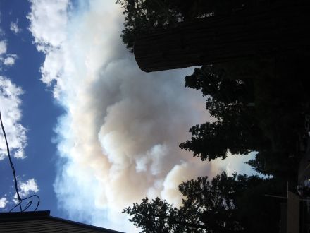
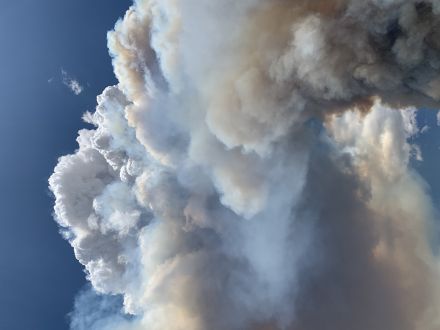
Here’s a few.


Re: EL DORADO FIRE Updates
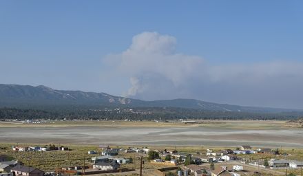
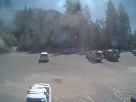
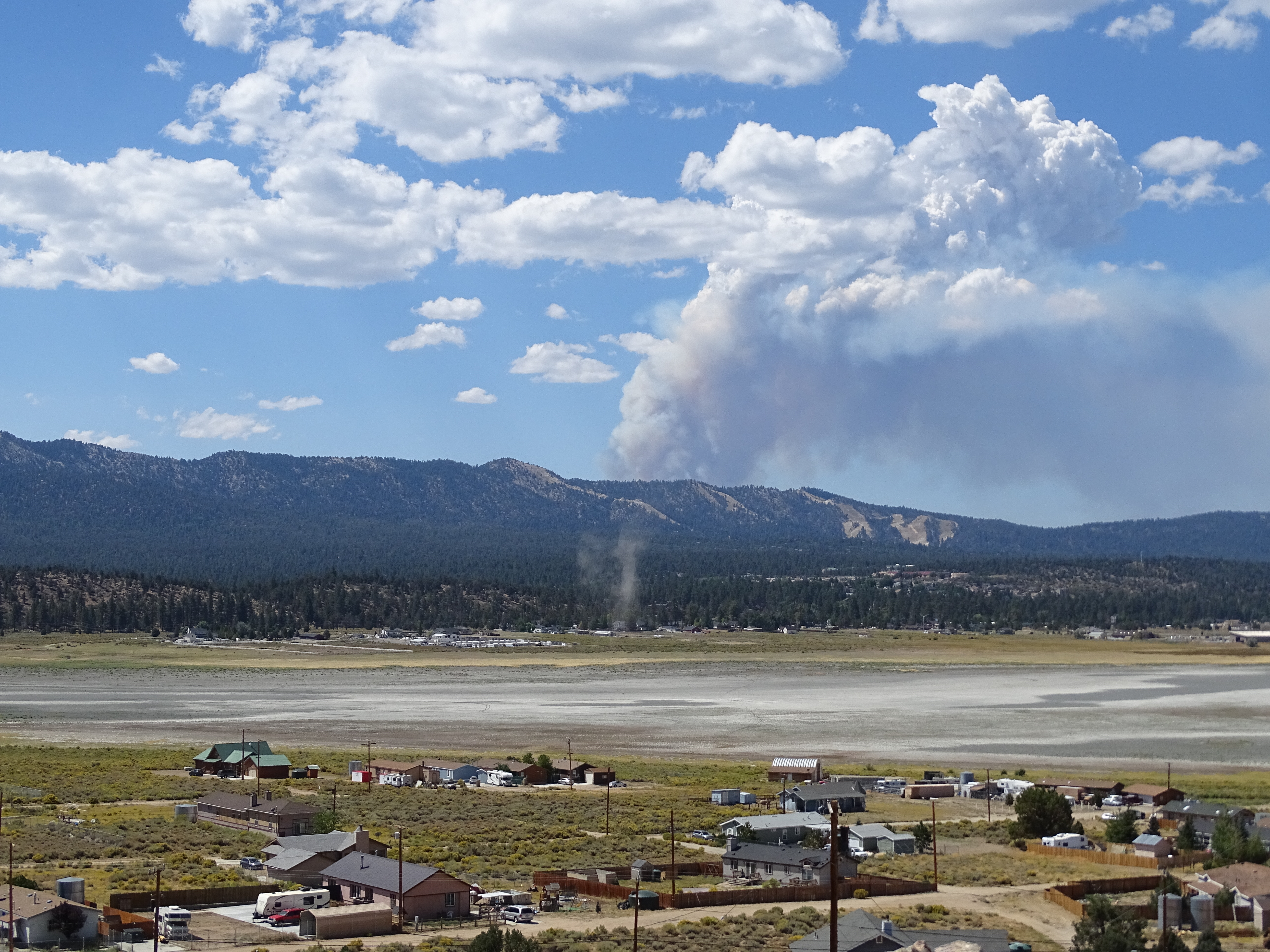
doo·hick·ey, Sat Sep 05 2020, 02:34PM
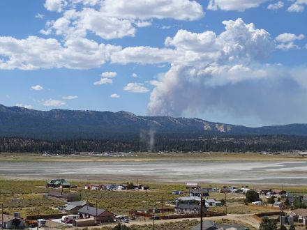
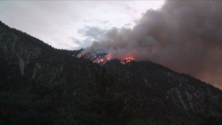
Stay safe KrazyKristin !
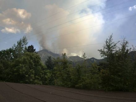
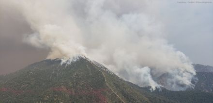
Here's a shot from Baldwin at 11:38am
Funny to catch a dust devil just below it.
Re: EL DORADO FIRE Updates
marley1, Sat Sep 05 2020, 02:36PM
[image][/img]
Re: EL DORADO FIRE Updates
FF Mac, Sat Sep 05 2020, 02:40PM
Another
Re: EL DORADO FIRE Updates
Deb Doodah, Sat Sep 05 2020, 03:04PM
HERE IS A VIDEO (3D VIEW) OF AIR TANKER 911 (DC10) MAKING A DROP ON THE EL DORADO FIRE AND THEN RETURNING TO THE SB TANKER BASE. USES FLIGHT SIMULATOR GRAPHICS AND TERRAIN. GIVES YOU A PERSPECTIVE ON THE AREA. DROP TOOK PLACE AT ABOUT 2:15PM
LINK TO VIDEO: [Click Here]
Re: EL DORADO FIRE Updates
©ammy, Sat Sep 05 2020, 03:47PM
View looking southwest from a webcam near the bridge over Mill Creek in Forest Falls @ 3:45pm:

Source: [Click Here]
Re: EL DORADO FIRE Updates
©ammy, Sat Sep 05 2020, 03:48PM
View looking southeast from a webcam in Mountain Home Village @ 3:45pm:
Source: [Click Here]
Re: EL DORADO FIRE Updates
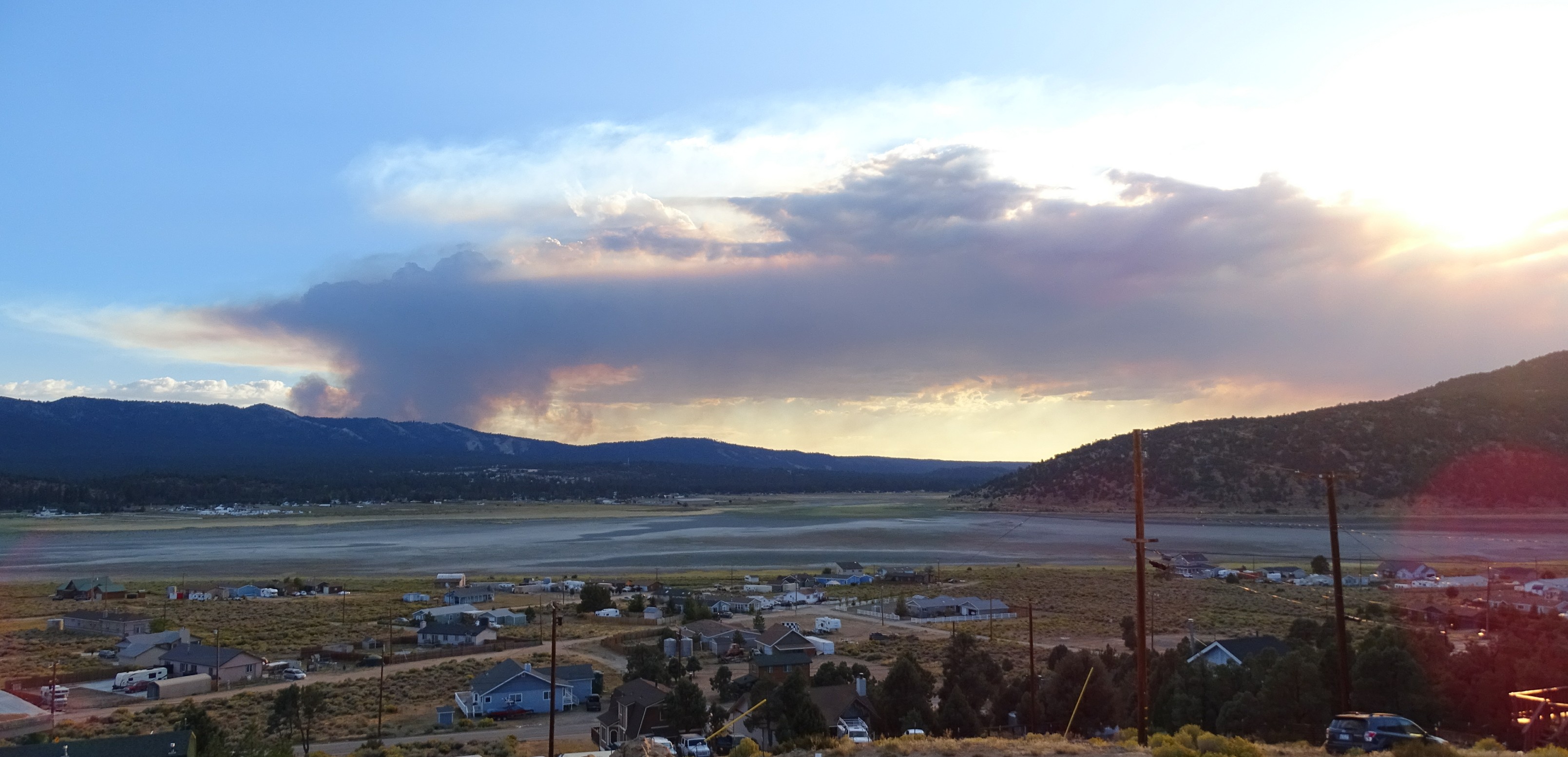
doo·hick·ey, Sat Sep 05 2020, 06:16PM
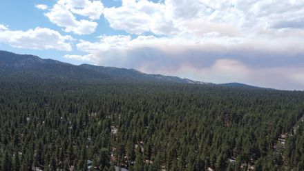
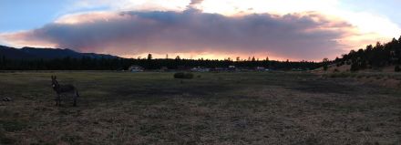
Another view from Baldwin Lake 6 hours later

Re: EL DORADO FIRE Updates
mcSQUIRREL, Sat Sep 05 2020, 07:23PM
Re: EL DORADO FIRE Updates
©ammy, Sat Sep 05 2020, 08:35PM
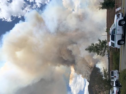
A couple photos from Yucaipa this evening. Photos by: my mom.

Re: EL DORADO FIRE Updates
©ammy, Sat Sep 05 2020, 08:41PM
From the Mtn. Care cameras this evening around 7:15pm:

Source: [Click Here] & [Click Here]
Re: EL DORADO FIRE Updates
-WINGNUT-, Sat Sep 05 2020, 09:51PM
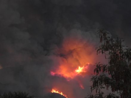
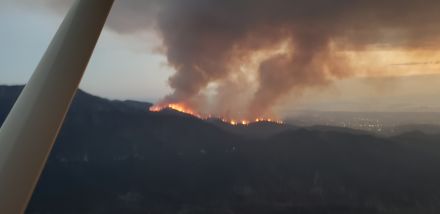
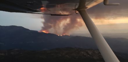
Decided to take a few laps around the valley to check out the fire. Moving pretty quick.

Re: EL DORADO FIRE Updates
-WINGNUT-, Sat Sep 05 2020, 09:52PM
Smokey at 9500 feet. Very little wind.
Re: EL DORADO FIRE Updates
-WINGNUT-, Sat Sep 05 2020, 09:57PM
Pictures with a phone so they are not the best.

Re: EL DORADO FIRE Updates
KrazyKristin, Sun Sep 06 2020, 07:43AM
Sunday morning from Forest Falls post office
Re: EL DORADO FIRE Updates
BBNona, Sun Sep 06 2020, 07:44AM
Good pics in my opinion! Thanks Wingnut
Re: EL DORADO FIRE Updates
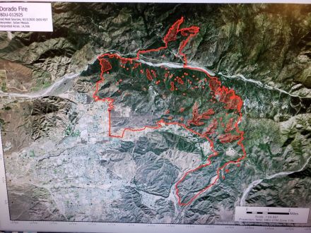
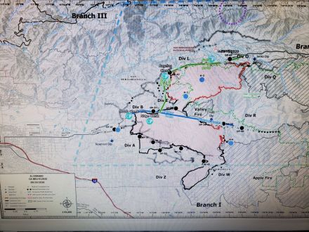
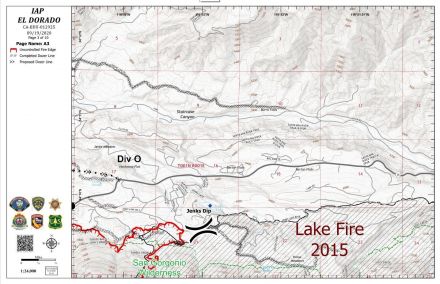
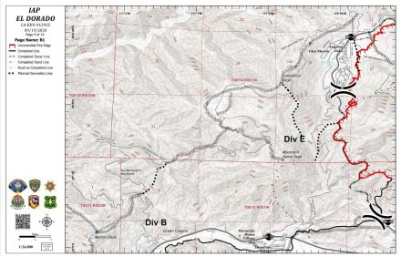
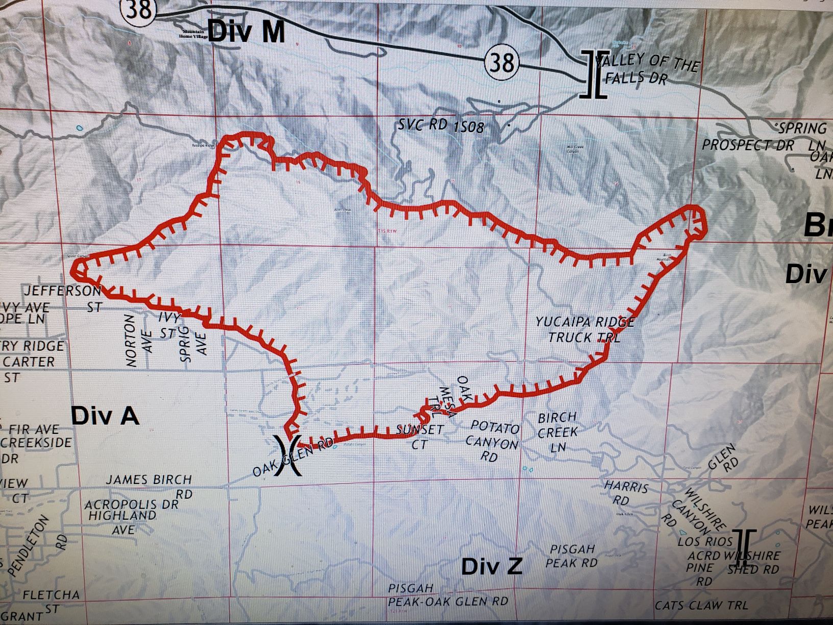
Mtngoat John⭐, Sun Sep 06 2020, 08:30AM
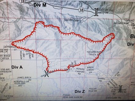
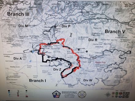
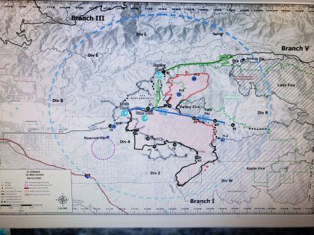
Photo of this mornings briefing map
Click image to enlarge
Re: EL DORADO FIRE Updates
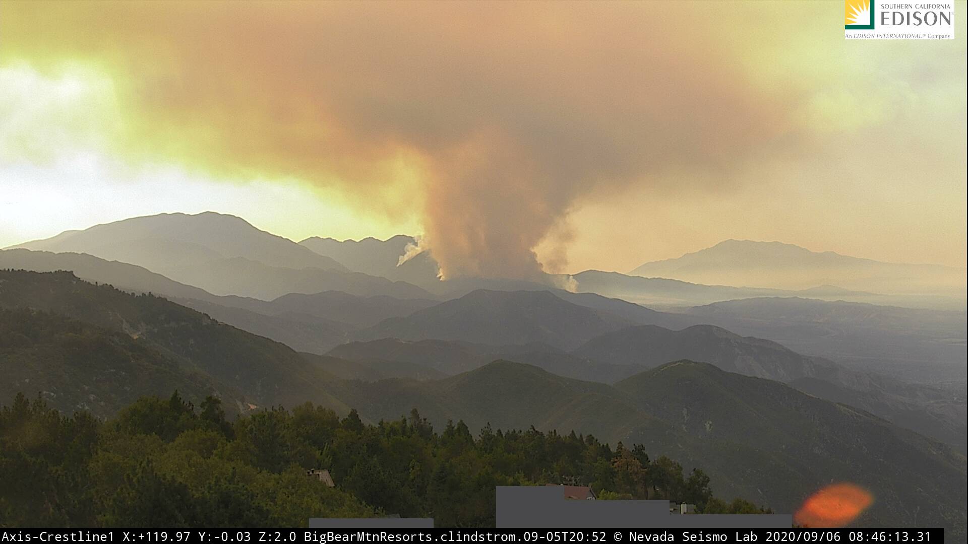
Mtngoat John⭐, Sun Sep 06 2020, 08:49AM
Current image from the AWF Crestline camera
Click image to enlarge

Re: EL DORADO FIRE Updates
Mtngoat John⭐, Sun Sep 06 2020, 09:06AM
Most current info posted
El Dorado, Vegetation Fire, San Bernardino County, Update
Oak Glen Rd x Potato Canyon Rd, west of Oak Glen
Federal/State/Local DPA, FRA/SRA/LRA, San Bernardino National Forest, San Bernardino Unit, Yucaipa Fire Department
3,010 acres (+2,010 acres), grass and brush, 5% contained (+5% containment)
Active fire behavior with uphill runs, group torching and short-range spotting
Structures remain threatened
Evacuation orders in place
Threat to communities of Oak Glen, Mountain Home Village, Forest Falls and City of Yucaipa
Threat to the San Gorgonio Wilderness including the Pacific Crest Trail and will impact Class 1 airshed
Threat to power grid infrastructure and hydroelectric power plant and apple orchards in Oak Glen
Unified command with USFS and CAL FIRE and Yucaipa Fire Department
CAIIMT 11 (Fogle) assumed command 0700
Federal air and ground resources assigned
Re: EL DORADO FIRE Updates
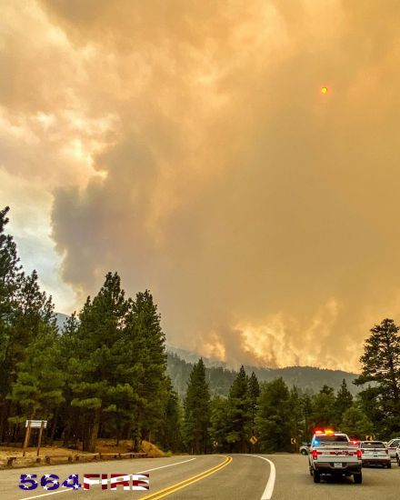
Mtngoat John⭐, Sun Sep 06 2020, 12:32PM
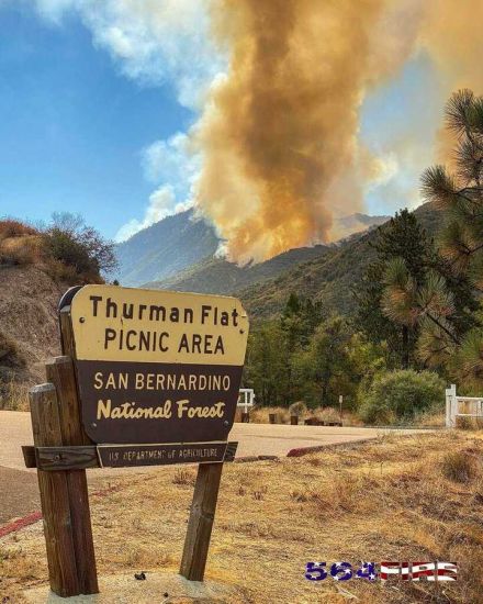
Earlier this morning courtesy of 564FirePhoto
Re: EL DORADO FIRE Updates
Mtngoat John⭐, Sun Sep 06 2020, 03:23PM
[Click Here]
Video posted by 564FirePhoto on the El Dorado Fire
Re: EL DORADO FIRE Updates
SCM ALERT🚨, Sun Sep 06 2020, 06:20PM
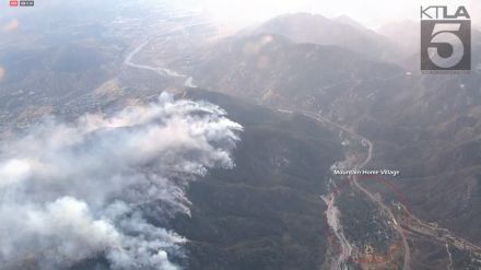
KTLA was just flying over the El Dorado Fire and I grabbed a screenshot to give you some perspective on where the fire is creeping down the ridge towards Mtn Home Village. With northerly winds and working downslope, it's not moving much. Granted, still too close for comfort! -Ben
[click to enlarge]
Re: EL DORADO FIRE Updates
SCM ALERT🚨, Sun Sep 06 2020, 06:52PM
INCIWEB EVENING UPDATE - SUN 9/6 @ 6:30pm
( Link: [Click Here] )
ACRES: 3010
CONTAINMENT: 5%
The El Dorado Fire started at approximately 10:30 a.m. on Saturday, September 5 at El Dorado Ranch Park in Yucaipa, Calif. The first engines on-scene reported several acres of fire with a Rapid Rate of Spread. The Fire was estimated at 3,010 acres with 5% containment. The fire burned actively overnight, and smoke will continue to impact portions of the Inland Empire today. The Southern California AQMD has issued a Smoke Advisory. Visit [Click Here] for air quality updates in your area.
Evacuations Orders (Mandatory)
Revised New Order - North Bench Yucaipa (All Resident north of Yucaipa Blvd, East of Bryant, and south of Hwy 38, and all residents North of Carter, west of Bryant, and South of Highway 38) )
- Evacuation Order: Oak Glen (partial, see road closures),
- Hwy 38 Area of Mountain Home Village and Forest Falls
A Red Cross reception site for evacuees is located at the Yucaipa Community Center, 34900 Oak Glen Rd, Yucaipa, CA 92399
San Bernardino County Residents: Sign up for San Bernardino County Telephone Emergency Notification System, by visiting [Click Here]
Road Closures
- Highway 38 at Bryant St. in Yucaipa and the community of Angelus Oaks
- Oak Glen Rd. between Pine Bench Rd. and Cherry Croft Dr.
- Bryant Street North of Yucaipa Blvd.
There is a soft closure on Highway 38 at Lake Williams Dr. (south of Big Bear, CA) to warn drivers of the closure in Angelus Oaks
Recreation Closures
- All San Gorgonio Wilderness, Trails, Trailheads and associated Parking Lots Except for the Pacific Crest Trail remains open.
- Other Trails: Big Falls, Oak Glen Divide, Wilson Creek
- Picnic Areas: Falls and Thurman Flats
- General Areas: Yucaipa Ridge, Mill Creek drainage and off-trail areas of the San Gorgonio Wilderness south of the San Bernardino Peak Divide Trail, Santa Ana River Trail between 1S14 and Middle Control Road.
- Thomas Hunting Grounds Yellow Post Sites
- Forest Roads: 1N12 (Near Angelus Oaks), 1S12 (Warm Springs Road), 1S13 and 1S03
Unified Command Partners
- CAL FIRE BDU
- San Bernardino County Fire
- San Bernardino County Sheriff's Department
- California Highway Patrol
- City of Yucaipa
- San Bernardino National Forest
Aviation and Drone Safety:
The FAA has issued a Safety No Fly Zone for civilian aircraft around the El Dorado Fire. Restricted Air Space is 5 Nautical Mile Radius from the Fire, and below 10,000 feet. This includes all types of personal hobby drones. Remember, If you Fly, We Cant! For specifics, please visit the FAA NOTAM Webpage.
Incident Information
Basic Information
Current as of 9/6/2020, 6:23:28 PM
Incident Type Wildfire
Cause Under Investigation
Date of Origin Saturday September 05th, 2020 approx. 10:30 AM
Location Yucaipa Ridge area, West Oak Glen, San Bernardino Mountains
Incident Commander Fogle with CA Interagency Incident Management Team 11
Coordinates 34.053 latitude, -116.992 longitude
Current Situation
Total Personnel 600
Size 3,010 Acres
Percent of Perimeter Contained 5%
Fuels Involved
Grass and Chaparral transitioning to timber in higher elevations
Outlook
Planned Actions
Engines will provide structure defense in the communities that are impacted by the fire. Other resources will work on perimeter control supported by the air assets.
Re: EL DORADO FIRE Updates
Mtngoat John⭐, Mon Sep 07 2020, 07:15AM
El Dorado, Vegetation Fire, San Bernardino County, Update
Oak Glen Rd x Potato Canyon Rd, west of Oak Glen
Federal/State/Local DPA, FRA/SRA/LRA, San Bernardino National Forest, San Bernardino Unit, Yucaipa Fire Department
7,386 acres (+336 acres), grass and brush, 7% contained (+2% containment)
Active fire behavior with running, flanking and group torching
Structures remain threatened
Evacuation orders in place
Road closures in the area
Red Flag warning in place, and an excessive heat waring remains in effect until 8pm Monday
Threat remains to communities of Oak Glen, Mountain Home Village, Forest Falls and City of Yucaipa
Threat to the San Gorgonio Wilderness including the Pacific Crest Trail and will impact Class 1 airshed
Threat to power grid infrastructure and hydroelectric power plant and apple orchards in Oak Glen
Damage inspection team in place
FMAG application approved
Unified command with USFS and CAL FIRE and Yucaipa Fire Department
CAIIMT 11 (Fogle) in command
Federal air and ground resources assigned
Re: EL DORADO FIRE Updates
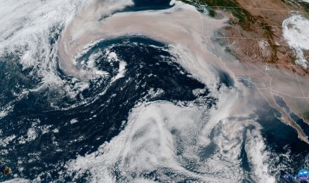
Spiceguy , Mon Sep 07 2020, 08:22AM
Entire state covered in smoke.
Re: EL DORADO FIRE Updates
HazMatMind, Mon Sep 07 2020, 08:26AM
MSNBC just said El Dorado started at a gender reveal party. People, sigh.
Re: EL DORADO FIRE Updates
Deb Doodah, Mon Sep 07 2020, 10:19AM
Copying into the thread so that it doesn't disappear.
Posted in chat by Johnny U. on Monday 07 September 2020 - 08:43:02
A short smoky vid of the Eldorado fire from F-F. Today, 9/7/20, 7 A.M. [Click Here]
Re: EL DORADO FIRE Updates
SCM ALERT🚨, Mon Sep 07 2020, 03:53PM
[TIMELAPSE] EL DORADO FIRE MONDAY 9/7
Timelapse of the El Dorado Fire from the BensWeather SANG Camera. Covers Today from 12am to 2pm.
You can see some flare ups overnight as well as a big one around 7am.
Re: EL DORADO FIRE Updates
SCM ALERT🚨, Mon Sep 07 2020, 04:45PM
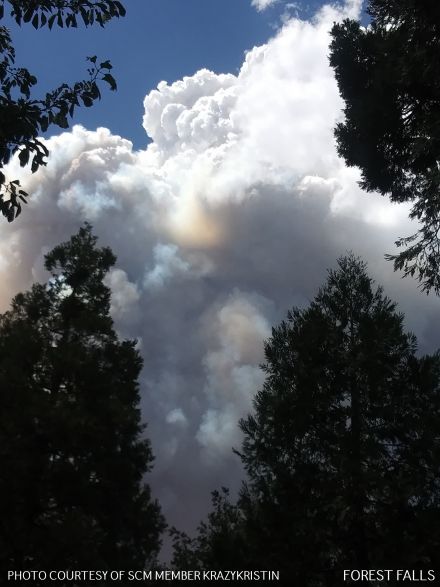
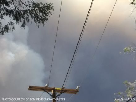
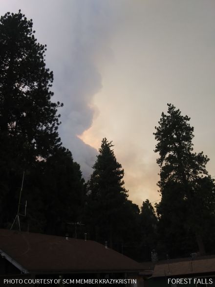
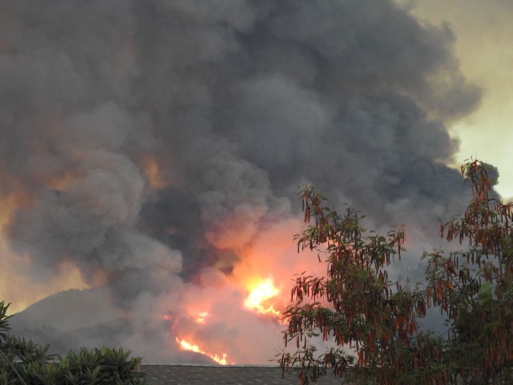
EL DORADO FIRE PHOTOS
PHOTOS BELOW CONTRIBUTED BY SCM MEMBER KRAZYKRISTEN WHO IS IN FOREST FALLS

Re: EL DORADO FIRE Updates
SCM ALERT🚨, Mon Sep 07 2020, 04:45PM
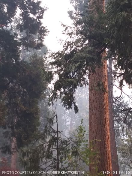
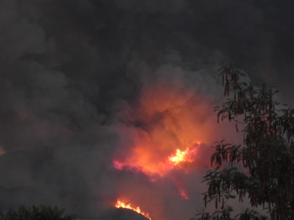
EL DORADO FIRE PHOTOS
PHOTOS BELOW CONTRIBUTED BY SCM MEMBER KRAZYKRISTEN WHO IS IN FOREST FALLS


Re: EL DORADO FIRE Updates
SCM ALERT🚨, Mon Sep 07 2020, 04:46PM
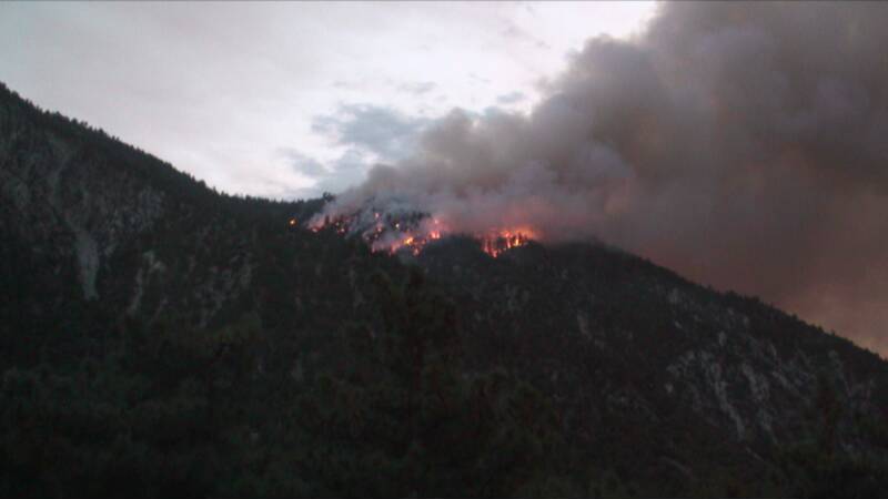
EL DORADO FIRE PHOTOS
PHOTOS BELOW CONTRIBUTED BY SCM MEMBER KRAZYKRISTEN WHO IS IN FOREST FALLS

Re: EL DORADO FIRE Updates
furrymurry8114, Mon Sep 07 2020, 04:58PM
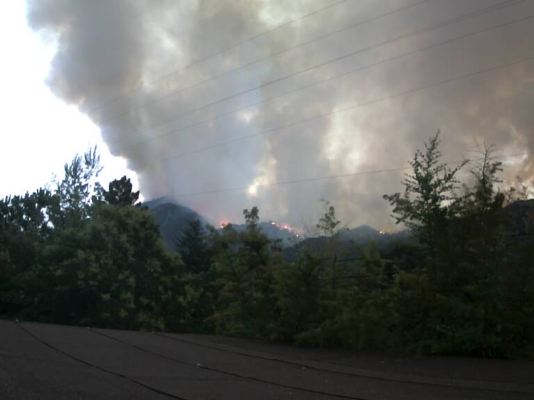
From the southern tip of Angelus Oaks looking down towards MHV.
 trim.4bbe12b0-859c-4a0a-8e18-f2045f404dfd.mov
Re: EL DORADO FIRE Updates
SCM ALERT🚨, Mon Sep 07 2020, 05:27PM
Thank you for sharing that Video Furry! Definitely looks scary! (Also great to hear from you!).
Re: EL DORADO FIRE Updates
SCM ALERT🚨, Mon Sep 07 2020, 11:08PM
MON EVENING (9/7) 11PM - EL DORADO FIRE UPDATE
Good progress was made today. Firefighters were able to put black line around Mountain Home Village to protect homes. A burnout operation was also conducted on the eastern fire perimeter.
Current Conditions:
Firefighters made good progress on the El Dorado Fire today. There was no major wind event during the day. Firefighters were able to put black line around the Mountain Home community in the Mill Creek drainage to protect homes as the fire burns downslope on this northern perimeter. A burnout operation was also conducted on the eastern fire perimeter, between Oak Glen Road and the Apple Fire burn scar. The strategy in this area is to clear the vegetation to prevent the fire from escaping and moving towards homes.
On the north side of Yucaipa Ridge, the fire activity remains much calmer and crews are working on holding the fire at the Mill Creek wash along Hwy 38 at Mountain Home Village and into Forest Falls. The hard work of crews on the ground, dozers and aircraft have enabled a lot of great work to be accomplished as fire lines continue to be constructed around the fire in preparation for the upcoming Red Flag Santa Ana Wind event starting at noon tomorrow and lasting through Wednesday.
The weather will remain dry and hot throughout the night. The fuels remain receptive to burning which creates a potential for large fire movement.
Residents, please heed evacuation orders, please stay out of the fire area. The Red Cross Temporary Evacuation Point has been moved to the cafeteria at Redlands East Valley High School 31000 E. Colton Ave in Redlands.
CLOSURES AND EVACUATIONS
ROAD CLOSURES:
• Highway 38: Northbound Highway 38 is closed at Bryant Ave. and Southbound Highway 38 is closed at the town of Angelus Oaks.
• Oak Glen Road: Closed at Pine Bench Rd on the east and Cherry Croft/Jefferson on the west.
EVACUATIONS:
Evacuation Order: Yucaipa Blvd at Bryant intersection to the east. Yucaipa Blvd to Ave E southeast to the intersection of Mesa Grande, east to Wildwood Canyon Rd to include all portions of Hidden Meadows and the southern portion of the Cherry Valley Community from Nancy Lane east to Beaumont Ave. Including portions of Riverside County down to Orchard St.
Oak Glen (partial, see road closures), Mountain Home Village, Forest Falls and North Bench Yucaipa (north of Carter St to Highway 38 and both sides of Bryant St east & west).
Evacuation Warning: Evacuation warning in place for Beaumont Ave east to Hillside Place in the Highland Springs area to the Apple Fire burn perimeter to the north and Cherry Valley Blvd to the south.
SAN BERNARDINO NATIONAL FOREST RECREATION CLOSURES:
The entire Forest was closed to all public use at 5PM today. Please see [Click Here] for more information.
Re: EL DORADO FIRE Updates
Hooky Bobber, Tue Sep 08 2020, 05:58AM
9.8.2020

Re: EL DORADO FIRE Updates
AudioGuy, Tue Sep 08 2020, 09:46AM
Good grief, that map makes it look like Oak Glen and Mountain Home got it. But it hasn't???
Re: EL DORADO FIRE Updates
Jellylorum, Tue Sep 08 2020, 11:07AM
I saw an interview yesterday with the owner(?) of Oak Tree Village. The fire was very close, it got one of their barns, but the other buildings are OK.
Re: EL DORADO FIRE Updates
SCM ALERT🚨, Tue Sep 08 2020, 12:50PM
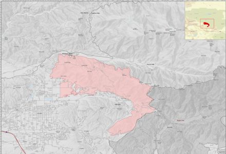
DORADO FIRE - UPDATED FIRE MAP TUE 9-8-2020
[Click to Enlarge]
Re: EL DORADO FIRE Updates
springvalley, Wed Sep 09 2020, 08:50AM
I'm kind of curious - do they consider the apple fire perimeter to be part of the "Containment"? or, is Containment (19%) just the parts of the fire that have some bureaucratic specified conditions achieved? One version would make the containment much higher (19%) PLUS the apple fire scar - where the fire's not going anywhere but has no official line around that portion....
Re: EL DORADO FIRE Updates
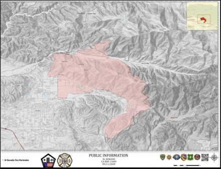
Mtngoat John⭐, Wed Sep 09 2020, 02:43PM
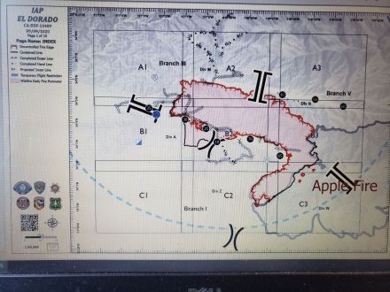
To answer the question posed in chat regarding dozer lines in Forest Falls, there are none. This mornings Incident Action Plan map.
Click image to enlarge
Re: EL DORADO FIRE Updates
Mtngoat John⭐, Wed Sep 09 2020, 07:40PM
Update
12,474 acres and now 18% containment
El Dorado, Vegetation Fire, San Bernardino County, Update
Oak Glen Rd x Potato Canyon Rd, west of Oak Glen
Federal/State/Local DPA, FRA/SRA/LRA, San Bernardino National Forest, San Bernardino Unit, Yucaipa Fire Department
12,474 acres (+995 acres), grass and brush, 18% contained (-1% containment)
Active fire behavior with backing, flanking, and creeping
Structures remain threatened
Evacuation orders remain in place
Fire has spotted over Hwy 38 and become well established below Angelus Oaks
Threat to communities of Angelus Oaks, Forest Falls, Yucaipa, Mountain Home Village, Pinezanita, Glen Martin School, Mile High Ranch, Pine Mtn Bench and apple orchards in Oak Glenn
Continued threat to cultural resources, critical infrastructure, commercial buildings, critical habitats and endangered species
Threat to the San Gorgonio Wilderness including the Pacific Crest Trail and will impact Class 1 airshed
Vegetation is critically dry and receptive to spotting
Fire is burning in steep, rugged and in-assessible terrain
Damage inspection is ongoing
Red flag warning in effect for next 12 hours, due to Santa Ana conditions with wind gusts of 25-40 mph
Road closures in area
Unified command with USFS, CAL FIRE, Yucaipa Fire Department and San Bernardino County Fire
CAIIMT 11 (Fogle) in command
Federal air and ground resources assigned
Re: EL DORADO FIRE Updates
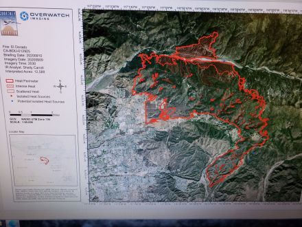
Mtngoat John⭐, Thu Sep 10 2020, 06:57AM
Last nights IR mapping
Click image to enlarge
Re: EL DORADO FIRE Updates
SCM ALERT🚨, Thu Sep 10 2020, 07:14AM
EL DORADO FIRE INCIWEB UPDATE
THURSDAY 9/10 AT 7AM
EVACUATION ORDERS
- Areas east of Bryant from Highway 38 South to Yucaipa Blvd, then east on Yucaipa Blvd at Bryant intersection to Freemont Street, then South to Grande View Drive, then along Ave E southeast to the intersection of Mesa Grande, east to Wildwood Canyon Rd to include all portions of Hidden Meadows, and east to Edgar Canyon Road.
- The portion of the Cherry Valley Community that is north of Orchard St to the County Line , and East of Nancy Ave. and west of Beaumont Ave..
- Oak Glen (partial, see road closures), Mountain Home Village and Forest Falls
- New - All residents located North of Valley of the Falls Drive along Highway 38 to Onyx Summit, including the Angelus Oak, 7 Oaks and Jenks Lake Area. You must drive North to Big Bear, CA as Highway 38 is impacted by fire. Rock slides are also being reported along Highway 38 where the fire has loosened rocks.
Evacuation Warning (yellow) - Voluntary, but you should be prepared to leave at any time.
- Evacuation warning in place for east of Beaumont Ave east to Hillside Place in the Highland Springs area , North to Cherry Valley Blvd to the County Line Road.
- North of Oak Glen Road, West of Bryant, South of Highway 38, East of Garnet. Those who require additional time to evacuate, and those with pets and livestock should leave now.
A Red Cross reception site has moved. It is now located in the cafeteria of the Redlands East Valley High School, 31000 E. Colton Ave. Redlands
Emergency Notification Systems:
San Bernardino County Assistant Fire Chief Kat Opliger talks about the importance of the Telephone Emergency Notification System (TENS) in helping San Bernardino County manage evacuation notifications during fires and other emergencies.
San Bernardino County Residents: Sign up for San Bernardino County Telephone Emergency Notification System, or call 1-888-435-7565.
Riverside County Residents: Sign up for the Riverside County Swift911 System. Visit [Click Here] for updated information and preparedness information.
Road Closures:
- Highway 38 between Bryant St. in Yucaipa and Sugar Pine Drive in the community of Angelus Oaks
- Bryant Street Between Hwy 38 and Carter Street.
- Oak Glen Rd. between Pine Bench Rd. and Cherry Croft Dr.
- Cross Streets East of Bryant Street Between Yucaipa Blvd. and Carter St.
- Wildwood Canyon Drive between Mesa Grande and Oak Glen Road.
There is a soft closure on Highway 38 at Lake Williams Dr. (south of Big Bear, CA) to warn drivers of the closure in Angelus Oaks
Forest Closure Order of 8 National Forests:
As of 5:00 PM on Monday, September 7, the Regional Forester is closing 8 National Forests in Southern California, including the San Bernardino National Forest. This means the National Forest is temporarily closed to ALL public use due to the threat from high fire danger and firefighting resources being spread stretched to the limit. This includes driving Forest Roads, Hiking on Forest Trails, and being in any Forest Service Developed Recreation Areas. Please take the time to read and understand the Regional Forester's Decision Letter, and view the Forest Closure Order. This order will be reviewed daily.
Unified Command Partners
- CAL FIRE BDU
- San Bernardino County Fire
- San Bernardino County Sheriff's Department
- California Highway Patrol
- City of Yucaipa
- San Bernardino National Forest
Aviation and Drone Safety:
The FAA has issued a Safety No Fly Zone for civilian aircraft around the El Dorado Fire. Restricted Air Space is 5 Nautical Mile Radius from the Fire, and below 10,000 feet. This includes all types of personal hobby drones. Remember, If you Fly, We Cant! For specifics, please visit the FAA NOTAM Webpage.
Incident Information
Basic Information
Current as of 9/10/2020, 6:42:49 AM
Incident Type Wildfire
Cause Human Caused
Date of Origin Saturday September 05th, 2020 approx. 10:30 AM
Location Yucaipa Ridge area, West Oak Glen, San Bernardino Mountains
Incident Commander C. Fogle, CA Interagency Incident Management Team 11 and numerous cooperators in Unified Command.
Coordinates 34.053 latitude, -116.992 longitude
Current Situation
Total Personnel 1,244
Size 12,610 Acres
Percent of Perimeter Contained 23%
Fuels Involved
Grass and Chaparral transitioning to timber in higher elevations
Significant Events
Fire continued to grown on the steep terrain with moderate uphill runs and short range spotting.
Outlook
Planned Actions
Crews and dozers will continue to build direct line around the fire to limit spread to the north and west towards Angelus Oaks. Aircraft will be supporting direct line construction and contingency work. Defensive burnout operations could continue as needed. Resources will be working to mop up and secure other of the fire areas in and around structures. Engines will also provide structure defense in the community's that are impacted by the fire.
Current Weather
Developing high pressure over California and Nevada will bring a slow warming trend through Monday. Patchy night and morning low clouds and fog near the coast will become a little more widespread over the weekend. Toward the middle of next week, a trough of low pressure to the northwest will begin to strengthen the onshore flow and spread slow cooling inland. High pressure aloft over California and Nevada should bring a slow warming trend for Friday through Monday. There will be some return today of the smoke aloft from the fires in northern and central California in addition to the smoke from the fires in southern California in Los Angeles and San Bernardino Counties. This could reduce temperatures a few degrees from what would otherwise occur absent the smoke aloft.
Re: EL DORADO FIRE Updates
Mtngoat John⭐, Thu Sep 10 2020, 07:39AM
El Dorado, Vegetation Fire, San Bernardino County, Update
Oak Glen Rd x Potato Canyon Rd, west of Oak Glen
Federal/State/Local DPA, FRA/SRA/LRA, San Bernardino National Forest, San Bernardino Unit, Yucaipa Fire Department
12,610 acres (+136 acres), grass and brush, 23% contained (5% containment)
Active fire behavior with backing, flanking, and creeping
Structures remain threatened
Evacuation orders remain in place
Fire has spotted over Hwy 38 and become well established below Angelus Oaks
Threat to communities of Angelus Oaks, Forest Falls, Yucaipa, Mountain Home Village, Pinezanita, Glen Martin School, Mile High Ranch, Pine Mtn Bench and apple orchards in Oak Glenn
Continued threat to cultural resources, critical infrastructure, commercial buildings, critical habitats and endangered species
Threat to the San Gorgonio Wilderness including the Pacific Crest Trail and will impact Class 1 airshed
Vegetation is critically dry and receptive to spotting
Fire is burning in steep, rugged and in-assessable terrain
Damage inspection is ongoing
Red flag warning remain in effect for dry conditions with possible gusting winds
Road closures in area
Unified command with USFS, CAL FIRE, Yucaipa Fire Department and San Bernardino County Fire
CAIIMT 11 (Fogle) in command
Federal air and ground resources assigned
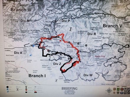
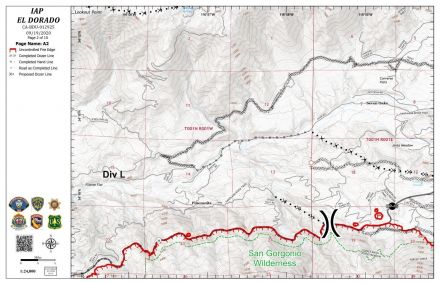
Re: EL DORADO FIRE Updates
Mtngoat John⭐, Thu Sep 10 2020, 08:08AM
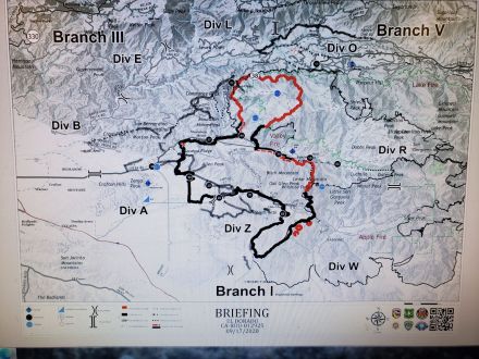
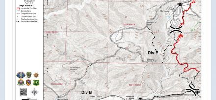
Briefing map 9-10-2020
Click image to enlarge
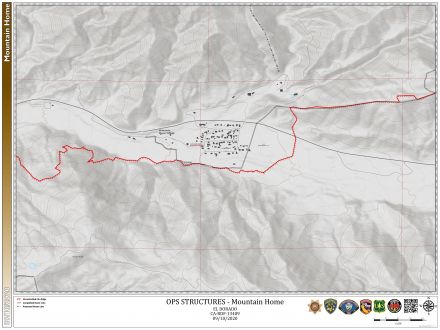
Re: EL DORADO FIRE Updates
SCM ALERT🚨, Thu Sep 10 2020, 10:44AM
FIRE PERIMETER MAP - MTN HOME VILLAGE 9-10-20
(click to enlarge)
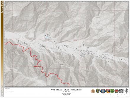
Re: EL DORADO FIRE Updates
SCM ALERT🚨, Thu Sep 10 2020, 10:45AM
FIRE PERIMETER MAP - FOREST FALLS 9-10-20
(click to enlarge)
Re: EL DORADO FIRE Updates
©ammy, Thu Sep 10 2020, 09:24PM
At least 5 dozers out working tonight. This is the Oaks Restaurant parking lot in Angelus Oaks:

Re: EL DORADO FIRE Updates
BBNona, Fri Sep 11 2020, 07:36AM
God bless our firemen...amazing how all the work they did protected Mtn home Village & Forest Falls. Looking at the fire map is you can see how it just missed both communities.
Re: EL DORADO FIRE Updates
Mtngoat John⭐, Fri Sep 11 2020, 07:52AM
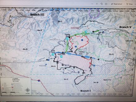
This mornings briefing map
Re: EL DORADO FIRE Updates
Mtngoat John⭐, Fri Sep 11 2020, 07:53AM
IR Mapping from last night
Click image to enlarge

Re: EL DORADO FIRE Updates
Mtngoat John⭐, Fri Sep 11 2020, 07:57AM
El Dorado, Vegetation Fire, San Bernardino County, Update
Oak Glen Rd x Potato Canyon Rd, west of Oak Glen
Federal/State/Local DPA, FRA/SRA/LRA, San Bernardino National Forest, San Bernardino Unit, Yucaipa Fire Department
13,715 acres (+123 acres), grass and brush, 31% contained (+0% containment)
Active fire behavior with flanking, single tree torching, and backing
Structures remain threatened
Evacuation orders remain in place
Fire is burning north of Hwy 38 above Mountain Home Village and Forest Falls and is well established
Threat to communities of Angelus Oaks, Forest Falls, Yucaipa, Mountain Home Village, Pinezanita, Glen Martin School, and scattered outbuildings
Continued threat to numerous cultural resources, critical infrastructure (including cell towers, radio towers, transmission lines, phone lines and transportation corridors), critical habitat for threatened and endangered species, Inventoried Roadless areas, San Gorgonio Wilderness including the Pacific Crest Trail
Vegetation is critically dry and receptive to spotting
Fire is burning in steep, rugged and in-assessable terrain
Damage inspection is ongoing
Road closures in area
Unified command with USFS, CAL FIRE, Yucaipa Fire Department and San Bernardino County Fire
CAIIMT 11 (Fogle) in command
Re: EL DORADO FIRE Updates
Deb Doodah, Fri Sep 11 2020, 11:05AM
Good Video Link....
Sep 11 : 10:35am
That is a great link for a first hand look! Thank you Marty!
(I copied Marty's post again below in case you missed it)
Marty
Sep 11 : 09:39am
The drive from Angelus Oaks to Forest Falls, 9/10/20.
[Click Here]
McToddy
Sep 11 : 11:01am
Here's a link to Marty's Part 2 video
[Click Here]
Re: EL DORADO FIRE Updates
AudioGuy, Fri Sep 11 2020, 11:53AM
Those links aren't "clickable"... at least not for me. Maybe check your embedded code for a mistake?
Re: EL DORADO FIRE Updates
Benny ⭐, Fri Sep 11 2020, 11:56AM
Something you don't see every day, while smoke covers the entire state, it's also wrapped off the west coast and wound into low pressure 1500 miles offshore. Even reaching up near the Aleutian islands! Expect similar conditions through the weekend with a gradual warm-up, winds will remain mostly light and variable.
Re: EL DORADO FIRE Updates
Mtngoat John⭐, Fri Sep 11 2020, 07:17PM
El Dorado, Vegetation Fire, San Bernardino County, Update
Oak Glen Rd x Potato Canyon Rd, west of Oak Glen
Federal/State/Local DPA, FRA/SRA/LRA, San Bernardino National Forest, San Bernardino Unit, Yucaipa Fire Department
13,920 acres (+205 acres), grass and brush, 38% contained (+7% containment)
Active fire behavior with flanking, single tree torching, and backing
Structures remain threatened
Evacuation orders remain in place
Evacuations orders are now lifted for all areas east of Jefferson and south of Carter
The Oak Glen area will be open to residents, business owners and employees only
Fire is burning north of Hwy 38 above Mountain Home Village and Forest Falls and is well established
Threat to communities of Angelus Oaks, Forest Falls, Yucaipa, Mountain Home Village, Pinezanita, Glen Martin School, and scattered outbuildings
Continued threat to numerous cultural resources, critical infrastructure (including cell towers, radio towers, transmission lines, phone lines and transportation corridors), critical habitat for threatened and endangered species, Inventoried Roadless areas, San Gorgonio Wilderness including the Pacific Crest Trail
Fire is burning in steep, rugged and in-assessable terrain
Road closures in area
Unified command with USFS, CAL FIRE, Yucaipa Fire Department and San Bernardino County Fire
CAIIMT 11 (Fogle) in command
Re: EL DORADO FIRE Updates
SCM ALERT🚨, Fri Sep 11 2020, 09:02PM
EL DORADO FIRE
FRIDAY SUMMARY (9/11)
Friday summary: ground crews are making an incredible effort in containing the EL DORADO fire. On the northern portion of Yucaipa ridge fire crews have continued the hard work of building fire line to secure the perimeter and aggressively attacking the fire. Air resources have aided in the fire fight with continuous water and retardant drops throughout the day. Structure protection continues in mountain home village and forest falls with securing fire lines along the creek. The fire continues to progress slowly downslope as it moves laterally along the creek. This has allowed fire crews a good opportunity to continue to prepare the area with securing handlines and increasing defensible space. Dozer line has been established north of the fire perimeter and south of angelus oaks from hwy 38 eastward to the 2015 lake fire scar. Ground crews are actively working to secure the contingency line with hose line placement. Smoke continues to be seen over the wildwood canyon area from fuels burning inside of the perimeter posing minimal threat to the fire line. Crews are actively patrolling the southern portion of Yucaipa ridge and extinguishing hot spots and flare-ups.
The weather remains dry and hot with minimal relative humidity recovery overnight. The wind will transition to downslope tonight at 4 to 8 mph gusting to 12 mph. California has issued a fuels advisory for excessively dry fuels due to the lack of precipitation in the area and excessive temperatures throughout the state. This allows the potential for active terrain driven fire behavior as wind and topography align.
The San Bernardino County Sheriff’s Department and the El Dorado Fire Unified Incident Commanders continue the advisory for visitors to consider rescheduling planned visits to the Big Bear area due to fire activity.
Neighbors, please stay vigilant and check Inciweb, Twitter and Facebook for changes on the #ElDoradoFire. There are physical signboards at the Stater Bros. shopping center in Beaumont at 1430 Beaumont Ave., 1775 east Lugonia Ave. in Redlands near the Starbucks and 11365 Bryant St. Yucaipa in the Stater Bros shopping center.
ROAD CLOSURES:
• Highway 38 is closed between Bryant St. to the south and Lake Williams Dr. to the north
• Topaz St. is closed at Bryant St. to eastbound traffic
• Juniper Ave. is closed at Bryant St.
• Carter St. is closed between Bryant St. and Jefferson St.
• Ivy is closed between Bryant St. and Jefferson St.
• Oak Glen Rd. access to residents, businesses and business support services only between lower Potato Cyn Rd. and Pine Bench Rd.
• Fremont St is closed at Carter St.
EVACUATIONS:
Evacuation Orders:
The El Dorado Fire remains under an Evacuation Order in Yucaipa: the neighborhood bordered by Bryant St. on the west, Carter St. on the south, Jefferson St. on the east, and Hwy 38 to the north. Angelus Oaks, Forest Falls, and Mountain Home Village also remain under evacuation order.
Evacuation Warning:
For portions of Mentone and Yucaipa: the areas bounded by the following streets remain in an evacuation warning: North of Oak Glen Road, West of Bryant, South of Highway 38 and East of Garnet.
SAN BERNARDINO NATIONAL FOREST RECREATION CLOSURES:
The entire Forest was closed to all public use at 5 p.m. on Monday, Sept. 7. Please see [Click Here] for more information.
(fire operations map - click to enlarge)
(evacuations map - click to enlarge)

Re: EL DORADO FIRE Updates
Mtngoat John⭐, Sat Sep 12 2020, 07:59AM
El Dorado, Vegetation Fire, San Bernardino County, Update
Oak Glen Rd x Potato Canyon Rd, west of Oak Glen
Federal/State/Local DPA, FRA/SRA/LRA, San Bernardino National Forest, San Bernardino Unit, Yucaipa Fire Department
14,043 acres (+123 acres), grass and brush, 39% contained (+1% containment)
Active fire behavior with flanking, single tree torching, and backing
Structures remain threatened
Evacuation orders and warnings remain in place
Evacuations orders are now lifted for all areas east of Jefferson and south of Carter
The Oak Glen area will be open to residents, business owners and employees only
Fire is burning north of Hwy 38 above Mountain Home Village and Forest Falls and is well established
Threat to communities of Angelus Oaks, Forest Falls, Yucaipa, Mountain Home Village, Pinezanita, Glen Martin School, and scattered outbuildings
Continued threat to numerous cultural resources, critical infrastructure (including cell towers, radio towers, transmission lines, phone lines and transportation corridors), critical habitat for threatened and endangered species, Inventoried Roadless areas, San Gorgonio Wilderness including the Pacific Crest Trail
Fire is burning in steep, rugged and in-assessable terrain
Road closures in area
Unified command with USFS, CAL FIRE, Yucaipa Fire Department and San Bernardino County Fire
CAIIMT 11 (Fogle) in command
Re: EL DORADO FIRE Updates
SCM ALERT🚨, Sat Sep 12 2020, 06:49PM
[EL DORADO FIRE] FULL UPDATE - 7PM UPDATE SAT 9/12
Acres: 14,212
Containment: 41%
PLANNED ACTIONS:
Crews and dozers will continue to build direct line around the fire to limit spread to the north and west towards Angelus Oaks. Aircraft will be supporting direct line construction and contingency work. Defensive burnout operations could continue as needed. Resources will be working to mop up and secure other of the fire areas in and around structures. Engines will also provide structure defense in the community's that are impacted by the fire.
REMARKS
Fire is north of the Hwy 38 between Mountain Home Village and Forest Falls and continues to burn in Frustration Creek and Monkeyface Creek burning north towards San Bernardino Peak and west towards Mountain Home Creek in very steep and rugged terrain. Fire behavior has been active during both day and night operations, and continues to be push down the slopes driven by diurnal winds with moderate rates of spread. The lack of appropriate types of resources is making it difficult to gain containment or control of the incident. High temperatures and critically low fuel moisture's are also contributing to a very high resistance to control and limiting operational planning options.
EVACUATIONS
MANDATORY EVACUTIONS:
All Residents located East of Brant, North of Carter, and West of Jefferson remain in under an Evacuation Orders.
All residents located east of Bryant Street on Highway 38 including Mountain Home, Forest Falls, Angelus Oak, 7 Oaks and Jenks Lake Area East to Onyx Summit. Note: Angelus Oaks / Seven Oaks Residents, You must drive North to Big Bear, CA as Highway 38 is impacted by fire. Rock slides are also being reported along Highway 38 where the fire has loosened rocks.
EVACUATION WARNINGS (BE PREPARED)
North of Carter, West of Bryant, South of Highway 38, East of Garnet.
Big Bear residents, please monitor the El Dorado Fire and stay informed on fire conditions.
ROAD CLOSURES
Highway 38 is closed between Bryant St. and Lake Williams Dr.
Topaz St. is closed at Bryant St. to eastbound traffic
Juniper Ave and Adams Street are closed east of Bryant St.
Fremont St is closed north of Carter St.
Ivy is closed between Bryant and Jefferson.
[Webcam shot from Big Bear ~6:30pm]
[Fire Burn Map created by Bensweather]
SUMMARY
Ground crews continue to make an incredible effort in containing the El Dorado Fire. Overnight, fire conditions were calm and allowed for good progress on securing the fire line, particularly in the Mill Creek drainage area. The fire is aligning itself with Skinner Creek along Highway 38, east of Mountain Home Village. As the wind transitions to up canyon winds this afternoon, there is the potential for large fire growth as weather and terrain align. Ground crews continue securing fire lines and air resources are utilizing retardant and water drops to slow fire progression.
Dozer line has been established north of the fire perimeter and south of Angelus Oaks along Hwy 38 for structure protection. Hand line is being constructed eastward to the 2015 Lake Fire scar. Ground crews are actively working to secure the contingency line with hose line placement. The fire continues to slowly move laterally behind Forest Falls along the creek. Firefighting efforts continue as crews extend the fire line from Vivian Creek to the old Apple Fire scar and continued structure defense. Smoke continues to be seen over the Wildwood Canyon area from fuels burning inside of the perimeter posing minimal threat to the fire line.
The fire is currently estimated at 14,043 acres with 39% containment. Damage assessment teams have completed assessments in the Oak Glen Area. Residences: 4 destroyed, and 2 damaged; Minor structures/outbuildings: 6 destroyed, and 4 damaged.
Operations Chief Dan Munsey provides an Morning Video Update (9/12) on the El Dorado Fire.
Read the September 12, 2020 Morning Update.
View a Close-up Map of the Forest Falls Area (9/10, pdf) or the Map of the Mountain Home Area (9/10,pdf) There was no growth in the Mtn. Home Area, and limited growth near the Forest Falls Area.
SMOKE IMPACTS:
Smoke will continue to impact portions of the Inland Empire and the San Gorgonio Pass area today and tonight, although much of the smoke in the upper atmosphere is from fires in central California.. The Southern California AQMD has issued a Smoke Advisory due to smoke from the El Dorado Fire and the Bobcat Fire. Visit [Click Here] for air quality updates in your area.
A Red Cross is located at the Redlands East Valley High School, 31000 E. Colton Ave. Redlands.
ALL FOREST LAND WITHIN THE STATE OF CALIFORNIA IS *CLOSED*
As of 5:00 PM on Monday, September 7, the Regional Forester is closing 8 National Forests in Southern California, including the San Bernardino National Forest. This means the National Forest is temporarily closed to ALL public use due to the threat from high fire danger and firefighting resources being spread stretched to the limit. This includes driving Forest Roads, Hiking on Forest Trails, and being in any Forest Service Developed Recreation Areas. Please take the time to read and understand the Regional Forester's Decision Letter, and view the Forest Closure Order. This order will be reviewed daily.
Re: EL DORADO FIRE Updates
SCM ALERT🚨, Sun Sep 13 2020, 06:49PM
EL DORADO FIRE UPDATE - SUN 9/13 @ 6PM
Acres: 14,283
Containment: 44%
Personnel: 1,319
Injuries: 10
Evacuated: 7,236
Homes damaged: 2
Homes destroyed: 4
Outbuildings damaged: 4
Outbuildings destroyed: 6
SCM Incident Link: [Click Here]
INCIDENT NARRATIVE
Hotshot crews began direct line construction in the Skinner Creek area above Hwy 38. They are being supported by specialized hose lays that are refilled by helicopters into portable tanks. This is needed due to the elevation change and rugged topography. Dozer lines are established south of Angelus Oaks along Hwy 38 for community protection. Ground crews are actively constructing a contingency line between Hwy 38 and the 2015 Lake Fire burn scar. The fire continues to back downhill above Forest Falls. Crews worked to extend the fire line along Mill Creek to Mill Creek Jumpoff. They will also be looking for opportunities to connect natural barriers i.e. rocks and scree slopes to prevent fire movement eastward. Smoke will remain visible in the Yucaipa and Oak Glen areas as unburned fuels within the fire perimeter continue to burn. Fire crews continue to patrol this area.
SIGNIFICANT EVENTS
Fire continued to grow on the steep terrain with moderate uphill runs and short range spotting.
EVACUATION UPDATE
At 7:00 this morning, San Bernardino County Sheriffs and Yucaipa Police Department announced that all evacuation zones south of Highway 38 and east and west of Bryant Street are lifted. Residents and businesses owners are allowed to return. Please be aware that fire personnel will still be monitoring the area and completing any additional work that needs to be completed.
The area east of Bryant Street on Highway 38 REMAINS UNDER AN EVACUATION ORDER. This including Mountain Home, Forest Falls, Angelus Oak, 7 Oaks and Barton Flats / Jenks Lake Area east to Onyx Summit. BIG BEAR RESIDENTS: Please monitor the El Dorado Fire on social media and stay informed on fire conditions.
ROAD CLOSURES
Highway 38 is closed between Bryant St. and Lake Williams Dr.
FOREST CLOSURE ORDER
Forest Closure Order of 8 National Forests:
As of 5:00 PM on Monday, September 7, the Regional Forester is closing 8 National Forests in Southern California, including the San Bernardino National Forest. This means the National Forest is temporarily closed to ALL public use due to the threat from high fire danger and firefighting resources being spread stretched to the limit. This includes driving Forest Roads, Hiking on Forest Trails, and being in any Forest Service Developed Recreation Areas. Please take the time to read and understand the Regional Forester's Decision Letter, and view the Forest Closure Order. This order will be reviewed daily.
AVIATION SAFTEY
The FAA has issued a Safety No Fly Zone for civilian aircraft around the El Dorado Fire. Restricted Air Space is 5 Nautical Mile Radius from the Fire, and below 10,000 feet. This includes all types of personal hobby drones. Remember, If you Fly, We Cant! For specifics, please visit the FAA NOTAM Webpage.
PLANNED ACTIONS
Crews and dozers will continue to build direct line around the fire to limit spread to the north and west towards Angelus Oaks. Aircraft will be supporting direct line construction and contingency work. Defensive burnout operations could continue as needed. Resources will be working to mop up and secure other of the fire areas in and around structures. Engines will also provide structure defense in the community's that are impacted by the fire.
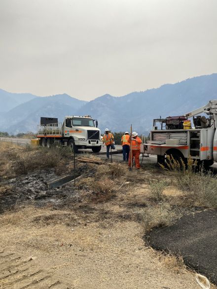
INCIDENT REMARKS
Fire is north of the Hwy 38 between Mountain Home Village and Forest Falls and continues to burn in Frustration Creek and Monkeyface Creek burning north towards San Bernardino Peak and west towards Mountain Home Creek in very steep and rugged terrain. Fire behavior has been active during both day and night operations, and continues to be push down the slopes driven by diurnal winds with moderate rates of spread. The lack of appropriate types of resources is making it difficult to gain containment or control of the incident. High temperatures and critically low fuel moisture's are also contributing to a very high resistance to control and limiting operational planning options.
[Photos: Caltrans continues work on damaged infrastructure]
[click to enlarge]

Re: EL DORADO FIRE Updates
Mtngoat John⭐, Mon Sep 14 2020, 07:17AM
Briefing map for 9-14-20
Click image to enlarge

Re: EL DORADO FIRE Updates
Mtngoat John⭐, Mon Sep 14 2020, 07:18AM
Overnight IR map
click image to enlarge
Re: EL DORADO FIRE Updates
doo·hick·ey, Mon Sep 14 2020, 08:53AM
After recently not seeing much smoke, today it is visible from Baldwin Lake.
Re: EL DORADO FIRE Updates
Jellylorum, Mon Sep 14 2020, 12:29PM
This will take you to the latest video report on the USFS Facebook page. It explains concerns about the fire flare this morning.
[Click Here]
Re: EL DORADO FIRE Updates
STAXX, Mon Sep 14 2020, 12:51PM
Satellite fire info...
[Click Here]
I needed some perspective... organized some info views:
[Click Here]
Re: EL DORADO FIRE Updates
HBadger, Mon Sep 14 2020, 01:17PM
trim.1fafe6ec-a6d2-4ce4-8e7e-4030bd1aebc3.mov
Re: EL DORADO FIRE Updates
Mtngoat John⭐, Mon Sep 14 2020, 03:18PM
Courtesy 564FirePhoto
Hwy38 and Jenks Lake Rd West
Re: EL DORADO FIRE Updates
Benny ⭐, Mon Sep 14 2020, 05:23PM
5:00pm Update - Monday 09/14/20
So a little better perspective. The photo below was just taken looking east towards Angelus Oaks. Angelus Oaks is on the bottom left below the retardant line. Winds have decreased so we're back to terrain driven, fire now running uphill towards San Bernardino Peak. They're going to try to run it east into the old Lake Fire scar. Might also do some backfiring operations tonight (wind permitting) behind/south of Jenks Lake and try to run it out of fuel on the north side. Fire is currently 1 mile south of highway 38, but just creeping downhill with slow rollout. Dozers are all over the place cutting/widening lines, around Angelus Oaks, down in Seven Oaks, and planning to work up along Skyline to have multiple contingencies to stop the fire, should it keep progressing north.
A 2,000 acre increase today.
6:30pm Update per USFS
Acres: 16,490
Containment: 53%
Personnel: 1,319
Injuries: 10
Evacuated: 3,467
Structures threatened: 16,117
More: [Click Here]
CLICK TO ENLARGE
Re: EL DORADO FIRE Updates
BBNona, Mon Sep 14 2020, 06:21PM
That’s awesome Benny. Those are some scary pics. Hope and pray everyone is out safe.
Re: EL DORADO FIRE Updates
Benny ⭐, Mon Sep 14 2020, 07:36PM
El Dorado Fire: September 14, 2020 PM Update
Public Information: San Bernardino National Forest: Twitter: @SanBernardinoNF
Phone: (909) 383-5688 [Click Here] Facebook: SanBernardinoNF
[Click Here]
INCIDENT INFORMATION
UNIFIED COMMAND: CAL FIRE BDU/Yucaipa, San Bernardino National Forest, San Bernardino County Fire, San Bernardino County Sheriff, California Highway Patrol
Start Date: 9/05/2020
Location: Oak Glen/West Yucaipa in
San Bernardino County CA
Size: 16,490 acres
Percent containment: 53%
Cause: Human-caused
ASSIGNED RESOURCES:
Hand Crews: 19
Helicopters: 11
Engines: 205
Dozers: 17
Water Tenders: 20
Total Personnel: 1,319
Injuries: 10
Structures Threatened: 16,117 Residence: Damaged 2 Destroyed: 4
Other Str: Damaged 4 Destroyed: 6
CURRENT CONDITIONS:
The El Dorado Fire burned actively throughout the day as the topography aligned with upslope wind influence allowing for active head fire runs. Firefighters have built a contingency line between the fire and the Angelus Oaks community to plan for this possibility. Currently, the fire is near Angelus Oaks but burning actively upslope towards San Bernardino Peak (northwest) towards the Lake Fire scar.
Fire activity will remain active overnight due to dry and hot weather with limited relative humidity recovery and a down canyon wind influence. Firefighters are poised and ready to conduct firing operations around Angeles Oaks if needed. The fire may back downslope gently towards the community. Fire crews are in position to directly attack the fire with both hand lines and hose lines.
There is NO evacuation directive for Big Bear residents at this time!!!
Along Hwy 38, the fire activity continues to slowly back down the slope and burn eastward along Mill Creek. The fire line behind Forest Falls continues to hold and firefighters continue to work in and around this community. Fire crews continue working to secure the fire line along Mill Creek from Vivian Creek to last month’s Apple Fire scar.
Residents of Mountain Home, we continue to ask for your patience. Our work in and around your community is not complete yet. Power lines are still down and we ask that you stay away from your homes for a little longer.
WEATHER:
The weather will remain hot and dry with upslope winds during the afternoons and downslope winds in the evening. Predictive Services division of the Southern California Geographic Area Coordination Center has issued a fuels advisory for excessively dry fuels throughout California due to drought conditions and hot temperatures.
Please check Inciweb, Twitter and Facebook for changes and updates on the #ElDoradoFire.
ROAD CLOSURES:
• Highway 38 is closed between Bryant St. to the south and Onyx Summit to the north
EVACUATIONS:
Evacuation Orders:
Evacuation Orders Remain In Effect for Mountain Home Village, Forest Falls, Angelus Oaks and Seven Oaks. All residents who have not yet evacuated in the Angelus Oaks area please leave!!!
Please see map link: [Click Here]
The physical temporary evacuation point at Redland’s East Valley High School will close tonight at 7:00 pm. Those seeking assistance tonight can call the virtual assistance line at (760)646-3824. Red Cross disaster workers will re-open the physical location for the Temporary Evacuation Point at Redland East Valley High School on Tuesday, September 15 at 7:00 am.
TRAVEL NOTES:
The El Dorado Fire Unified Incident Commanders continue to ask visitors to consider rescheduling planned visits to the Big Bear area due to fire activity. Please check the Big Bear Fire Department Travel Advisory for the reasons why: [Click Here]
SAN BERNARDINO NATIONAL FOREST RECREATION CLOSURES:
The entire Forest was closed to all public use at 5 p.m. on Monday, Sept. 7. Please see [Click Here] for more information.
Re: EL DORADO FIRE Updates
Kats, Mon Sep 14 2020, 07:37PM

Re: EL DORADO FIRE Updates
Benny ⭐, Mon Sep 14 2020, 08:15PM
Great photos!
Here's an evening update from Fire Chief Willis....
[Click Here]
Re: EL DORADO FIRE Updates
Mtngoat John⭐, Tue Sep 15 2020, 05:31AM
9-15-20 Briefing map
click image to enlarge

Re: EL DORADO FIRE Updates
Mtngoat John⭐, Tue Sep 15 2020, 05:32AM
9-15-20 Pilot Map
click image to enlarge
Re: EL DORADO FIRE Updates
McToddy, Tue Sep 15 2020, 10:28AM
Hey all --
I've put all my pics of the fire into one single album in Google Photos. I'll be adding more photos to this link over time
[Click Here]
Re: EL DORADO FIRE Updates
BootsNBridles, Tue Sep 15 2020, 11:38AM
Here's the link to the Flight Rader that shows all planes in the area: [Click Here]
Re: EL DORADO FIRE Updates
Squatch, Tue Sep 15 2020, 12:45PM
Awesome link!
Re: EL DORADO FIRE Updates
Mtngoat John⭐, Thu Sep 17 2020, 06:46AM
9-17-20 Briefing Map
Click image to enlarge
Re: EL DORADO FIRE Updates
Mtngoat John⭐, Thu Sep 17 2020, 06:47AM
This mornings Pilot Map
click to enlarge image
Re: EL DORADO FIRE Updates
Hooky Bobber, Fri Sep 18 2020, 07:11AM
deck 9/18 morning summit area
Re: EL DORADO FIRE Updates
Hooky Bobber, Fri Sep 18 2020, 07:12AM
Updates: Read the September 18, 2020 Morning Update.
Daily Videos - Operational Update from the El Dorado Fire (9/17).
View detailed Fire Perimeter Maps (9/18) for the Angelus Oaks Area, 7 Oaks / Pinezanita, Jenks Lake Area, and the San Bernardino Peak Area.
2020_09_16-16.30.04.561-CDT.jpeg
CURRENT CONDITIONS:
The El Dorado fire burned actively overnight along Hwy 38 into Angelus Oaks. Fire was spotting into the community and was quickly extinguished by fire crews providing structure defense. The fire continued to burn with high intensity along Hwy 38 near the Pinezanita area. Ember cast across Hwy 38 was quickly extinguished by ground crews directly attacking the fire with hose lines. Structure defense continues from Pinezanita to Jenks Lake by increasing defensible space, hose line placement and securing fire line. The fire has progressed to the Lake Fire scar and continues to make active runs to the north as topography and up-canyon wind influences comes into alignment. Fire is spotting ½ mile ahead of the main body of fire and has a potential for spotting up to 1 mile this afternoon.
There are no active spot fires that have crossed Hwy 38. We understand that many residents may be looking at Modis online. Modis is an instrument aboard the Terra and Aqua EOS Satellites and measure thermal and infrared detections. This can create confusion as anything emitting heat registers in Modis, including smoke AND fire-fighting equipment. What communities are perceiving as spot fires across Hwy 38 is likely smoke or equipment operating in the area. As of this update, the El Dorado Fire has NOT crossed Highway 38. Please know that the firefighters working in this area are monitoring this possibility very carefully.
Caifornia Interagency Incident Management Team 11(Fogle) transitioned with California Interagency Incident Management Team 13(Wakoski) today at 0700 am. The Unified Command remains in place with Cal Fire BDU/Yucaipa, San Bernardino National Forest, San Bernardino County Fire, San Bernardino County Sheriffs, and California Highway Patrol.
There is NO evacuation directive for Big Bear residents AT THIS TIME. Please monitor official sources for any changes including the San Bernardino National Forest information listed at the top of this update, San Bernardino Sheriff’s Department, the CAL Fire San Bernardino Unit and San Bernardino County Fire.
All residents waiting to return home: we ask for your continued patience. We are re-evaluating repopulation daily with the utility companies, CalTrans, CHP and San Bernardino County Sheriff’s Department as they repair critical infrastructure. We ask that you continue to support the firefighters by staying out of the way until we can open your neighborhood safely for you.
Angelus Oaks and Forest Falls Post Offices are closed temporarily, however residents of these communities can pick up their mail at the Yucaipa Post Office, located at 12460 California St, Yucaipa, CA 92305 until further notice. Please bring a valid photo ID when picking up mail. The Yucaipa Post Office is open Monday – Friday 9:00 to 5:00, Saturday 11:00 – 4:00.
The El Dorado Fire has been burning for 14 days, and is currently estimated at 21,678 acres with 66% containment.
Residences: 4 destroyed, and 2 damaged; Minor structures/outbuildings: 6 destroyed, and 4 damaged.
Weather:
A high-pressure weather system remains over the fire resulting in winds from the southwest above 6,000 feet elevation. The predominant diurnal winds continue below 6000 feet elevation and will transition to down canyon overnight.
Smoke Impacts:
Please read the Daily Smoke Report issued by the Wildland Fire Air Quality Program. Smoke will continue to impact portions of the Inland Empire and the San Gorgonio Pass area today and tonight, although much of the smoke in the upper atmosphere is from fires in central California. The Southern California AQMD has issued a Smoke Advisory due to smoke from the El Dorado Fire and the Bobcat Fire. Visit [Click Here] for air quality updates in your area.
Evacuations Orders:
The area east of Bryant Street on Highway 38 REMAINS UNDER AN EVACUATION ORDER. This including Mountain Home, Forest Falls, Angelus Oak, 7 Oaks and Barton Flats / Jenks Lake Area east to Onyx Summit.
Residents and businesses may check to see if they are within evacuation order or warning areas by going to the San Bernardino County Sheriffs Interactive Mapping Tool.
Big Bear residents, please monitor the El Dorado Fire and stay informed on fire conditions. Please check social media platforms frequently for updates on the #ElDoradoFire.
Fire Managers and Big Bear Emergency Agencies issued a Travel Advisory Notice for visitors to the Big Bear Area, who are urged to consider postponing their travel due to the El Dorado Fire.
A Red Cross is located at the Redlands East Valley High School, 31000 E. Colton Ave. Redlands.
Emergency Notification Systems:
San Bernardino County Assistant Fire Chief Kat Opliger talks about the importance of the Telephone Emergency Notification System (TENS) in helping San Bernardino County manage evacuation notifications during fires and other emergencies.
San Bernardino County Residents: Sign up for San Bernardino County Telephone Emergency Notification System, or call 1-888-435-7565.
Riverside County Residents: Sign up for the Riverside County Swift911 System. Visit [Click Here] for updated information and preparedness information.
Road Closures:
Highway 38 is closed between Bryant St. and Lake Williams Dr.
Recent Facebook Live Meeting:
A Facebook Live event was held on Sept 15th through the San Bernardino County Fire Facebook Page. Representatives from the San Bernardino County Board of Supervisors, San Bernardino County Fire, San Bernardino County Sheriffs Department, Cal Fire BDU, and California Incident Management Team 11 discussed the current activity on the El Dorado Fire, what things might happen with future evacuations, and answered questions that were posted online. Please take the time to watch this informative video by connecting to the San Bernardino County Fire Facebook. Meeting starts at 6:00, (Skip ahead).
Forest Closure Order of 8 National Forests:
The Regional Forester has closed All National Forests in California, including the San Bernardino National Forest. This is due to the threat from Extreme Fire Danger, rapid fire growth in new fires starts, and firefighting resources being spread stretched to the limit. This includes driving Forest Roads, Hiking on Forest Trails, and being in any Forest Service Developed Recreation Areas. Please take the time to read and understand the Regional Forester's Decision Letter. The Regional Forest Emergency Closure Order and Regional Forest Fire Restriction Order were extended to September 21st. These orders will be reviewed daily, and may be rescinded early if the underlying conditions which prompted the orders change.
Unified Command Partners:
- CAL FIRE BDU
- San Bernardino County Fire
- San Bernardino County Sheriff's Department
- California Highway Patrol
- City of Yucaipa
- San Bernardino National Forest
Aviation and Drone Safety:
The FAA has issued a Safety No Fly Zone for civilian aircraft around the El Dorado Fire. Restricted Air Space is 5 Nautical Mile Radius from the Fire, and below 10,000 feet. This includes all types of personal hobby drones. Remember, If you Fly, We Cant! For specifics, please visit the FAA NOTAM Webpage.
Re: EL DORADO FIRE Updates
Spiceguy , Fri Sep 18 2020, 07:41AM
Exactly what our decks looked like this morning as well.
Re: EL DORADO FIRE Updates
Hooky Bobber, Fri Sep 18 2020, 08:02AM
NWS forecast for AO EW9887 Angelus Oaks (E9887)
[Click Here]
Today
Widespread haze. Areas of smoke. Sunny, with a high near 74. Southwest wind 10 to 20 mph, with gusts as high as 30 mph.
Tonight
Widespread haze. Areas of smoke before 11pm. Mostly clear, with a low around 53. South wind 10 to 15 mph, with gusts as high as 20 mph.
Saturday
Widespread haze. Sunny, with a high near 72. Southwest wind 5 to 15 mph, with gusts as high as 25 mph.
Saturday Night
Clear, with a low around 52. South wind around 10 mph, with gusts as high as 20 mph.
Sunday
Sunny, with a high near 72. Southwest wind 5 to 10 mph, with gusts as high as 20 mph.
Re: EL DORADO FIRE Updates
Hooky Bobber, Sat Sep 19 2020, 04:49AM
Operations Chief Diaz Daily Video Update Sept 17
[Click Here]
Re: EL DORADO FIRE Updates
Hooky Bobber, Sat Sep 19 2020, 04:51AM
9/19 eldorado map

Re: EL DORADO FIRE Updates
Hooky Bobber, Sat Sep 19 2020, 04:58AM
Updates: September 18, 2020 Evening Update.
Daily Videos - Operational Update from the El Dorado Fire (9/17).
Detailed Fire Perimeter Maps (9/18) for the Angelus Oaks Area,7 Oaks / Pinezanita, Jenks Lake Area, and the San Bernardino Peak Area.
Current Condition:
The El Dorado Fire continued to burn actively along Hwy 38 and in and around Angelus Oaks. The fire spotted into the community but was quickly extinguished by crews in place to provide structure defense. The presence of these fire crews along with air support kept the fire on the South and East side of Highway 38.
The fire continues to impact the communities of Angelus Oaks, Mountain Home Village, Forest Falls, and threatens the areas of Glen Martin School, San Bernardino Peak, Anderson Peak, Pinezanita, Horse Flats, Barton Flats, Anderson Peak, and Heart Bar.
Fire growth continues to the northeast and has slowed as it moves into the old Valley and Lake Fire burn scars.
A well-attended community meeting was held in Forest Falls. Residents practiced coronavirus protocols with masks and social distancing.
Weather:
Dry, warm, and breezy conditions will continue over the fire on Saturday and Saturday evening. Winds will be west and Southwest 10 MPH Sustained with gust to 20 MPH. Temperatures will be around 85 degrees
There is NO evacuation directive for Big Bear residents AT THIS TIME. Please monitor official sources for any changes including the San Bernardino National Forest information listed at the top of this update, San Bernardino Sheriff’s Department, the CAL Fire San Bernardino Unit and San Bernardino County Fire.
All residents waiting to return home: we ask for your continued patience. We are re-evaluating repopulation daily with CHP, and San Bernardino County Sheriff’s Department. The utility companies, and CalTrans continue repairing critical infrastructure. Please be cautious and aware of crews working in the area.
Angelus Oaks and Forest Falls Post Offices are closed temporarily, however residents of these communities can pick up their mail at the Yucaipa Post Office, located at 12460 California St, Yucaipa, CA 92305 until further notice. Please bring a valid photo ID when picking up mail. The Yucaipa Post Office is open Monday – Friday 9:00 to 5:00, Saturday 11:00 – 4:00.
The El Dorado Fire has been burning for 14 days, and is currently estimated at 22,071 acres with 65% containment.
Residences: 4 destroyed and 2 damaged; Minor structures/outbuildings: 6 destroyed, and 4 damaged.
Smoke Impacts:
Please read the Daily Smoke Report issued by the Wildland Fire Air Quality Program. Smoke will continue to impact portions of the Inland Empire and the San Gorgonio Pass area today and tonight, although much of the smoke in the upper atmosphere is from fires in central California. The Southern California AQMD has issued a Smoke Advisory due to smoke from the El Dorado Fire and the Bobcat Fire. Visit [Click Here] for air quality updates in your area.
Evacuations Orders:
Community of Angelus Oak, 7 Oaks and Barton Flats / Jenks Lake Area east to Onyx Summit.
Evacuation Warnings:
Mountain Home Village and Forest Falls are now open to Residents Only. Please have ID.
Residents and businesses may check to see if they are within evacuation order or warning areas by going to the San Bernardino County Sheriffs Interactive Mapping Tool.
Big Bear residents, please monitor the El Dorado Fire and stay informed on fire conditions. Please check social media platforms frequently for updates on the #ElDoradoFire.
Fire Managers and Big Bear Emergency Agencies issued a Travel Advisory Notice for visitors to the Big Bear Area, who are urged to consider postponing their travel due to the El Dorado Fire.
A Red Cross is located at the Redlands East Valley High School, 31000 E. Colton Ave. Redlands.
Emergency Notification Systems:
San Bernardino County Assistant Fire Chief Kat Opliger talks about the importance of the Telephone Emergency Notification System (TENS) in helping San Bernardino County manage evacuation notifications during fires and other emergencies.
San Bernardino County Residents: Sign up for San Bernardino County Telephone Emergency Notification System, or call 1-888-435-7565.
Riverside County Residents: Sign up for the Riverside County Swift911 System. Visit [Click Here] for updated information and preparedness information.
Road Closures:
Highway 38 is closed between Bryant St. and Lake Williams Dr. Residents of Mountain Home Village and Forest Falls will be allowed through the Bryant Street Checkpoint. A Hard Closure is in place above Valley of the Falls Drive on Highway 38.
Re: EL DORADO FIRE Updates
Hooky Bobber, Sat Sep 19 2020, 04:59AM
Video link eldorado
[Click Here]
Re: EL DORADO FIRE Updates
Mtngoat John⭐, Sat Sep 19 2020, 05:45AM
This mornings Briefing Map
9-19-20
click image to enlarge

Re: EL DORADO FIRE Updates
Mtngoat John⭐, Sat Sep 19 2020, 05:46AM
9-19-20 Pilot map
click image to enlarge
Re: EL DORADO FIRE Updates
Hooky Bobber, Sun Sep 20 2020, 09:29AM
Updates: September 20, 2020 Morning Update
Detailed Fire Perimeter Maps (9/19) for the Angelus Oaks Area,7 Oaks / Pinezanita,Jenks Lake Area.
Daily Smoke Outlook - Los Angeles and Inland Empire Areas - September 19
Current Condition:
The El Dorado’s Fire behavior overnight has decreased compared to the previous daytime period. Fire behavior decreased to the east as it burns into the old Lake Fire burn scar. With the forecasted weather, firefighters continue to make progress building containment line and putting in hose lays around in key areas on the fire. The fire continues to backdown to Hwy 38 with some upslope runs. Spot fires remain a concern along the 38 corridor. The Oak Glen, Yucaipa, Banning, and Beaumont side of the fire have moved into patrol status.
The El Dorado Fire started on September 5, 2020, in El Dorado Park located in the Yucaipa/Oak Glen area of Southern California, which is managed by the California Department of Forestry and Fire Protection, CAL FIRE. Prior to the fire, Southern California was experiencing a series of heat waves. On the day of the fire, we had record breaking temperatures across the region. Due to the dry conditions and grass covered hills, the fire spread rapidly onto Forest Lands in the San Bernardino National Forest. With a record number of fires throughout California, fire resources are spread thin.
With high temperatures and dry vegetation, the public is encouraged to be more vigilant and cautious when recreating near public lands and open spaces. Residents should evaluate their properties for defensible space and ensure they have adequate hazard reduction.
Weather:
A trough of low pressure continued through the area today. This will continue southwest winds during the day and evening hours for most locations. Sheltered valleys will likely see down canyon winds at night and relative humidity will slowly increase this weekend. Temperatures 90-94 degrees at 3000’ and 77-80 degrees at 6000’
Re: EL DORADO FIRE Updates
Hooky Bobber, Sun Sep 20 2020, 09:32AM
Detailed Area Maps A O September 19
Re: EL DORADO FIRE Updates
Hooky Bobber, Sun Sep 20 2020, 09:35AM
Pinezanita Area OPS Map
Hope to pick apples in a couple weeks
Re: EL DORADO FIRE Updates
Hooky Bobber, Sun Sep 20 2020, 09:37AM
Jenks Lake ARea OPS Map
Re: EL DORADO FIRE Updates
Hooky Bobber, Sun Sep 20 2020, 09:40AM
Angelus Oaks Area OPS Map
Re: EL DORADO FIRE Updates
Hooky Bobber, Sun Sep 20 2020, 09:52AM
El Dorado Fire Perimeter, September 20, 2020
Re: EL DORADO FIRE Updates
Hooky Bobber, Sun Sep 20 2020, 12:30PM
Angles Oaks
Re: EL DORADO FIRE Updates
Hooky Bobber, Sun Sep 20 2020, 12:48PM
Re: EL DORADO FIRE Updates
Hooky Bobber, Tue Sep 22 2020, 06:57AM
SAN BERNARDINO, Calif., September 21, 2020 – It is with deep sadness that USDA Forest Service officials on the San Bernardino National Forest announce the death of Charles Morton, a Big Bear Interagency Hotshot Squad Boss, who died while engaged in fire suppression operations on the El Dorado Fire late Thursday, September 17, 2020.
Full Press Release, Photo
[Click Here]
Procession of vehiclestoescortfallen firefighter Charles Morton to Orange Countymortuary SAN BERNARDINO, Calif.–AU.S. Forest Servicehonor guard, along with the California Highway Patrol, will escort fallen Big Bear Interagency Hotshot Charles Mortonin a solemn processionto a mortuary in Orange Countyonthe morning ofTuesday, September22, 2020.The procession will begin at 10:30 a.m. from the main office of theSan Bernardino County Coroner’sDivisionin San Bernardino, Calif., and end at Ferrara & Lee Colonial Mortuaryin Orange, Calif.The route will be as follows: •Start at theSan Bernardino County Coroner’s Division main office at175 S. Lena Rd.,San Bernardino, Calif. 92415•South on Lena Rd. to Mill St.•Weston MillSt.to Waterman Ave.•South on Waterman to I-215 South Riverside Freeway•South toSR-91to Imperial Highway•South onImperial Highway to Santiago Canyon Rd.•West on Santiago Canyon Rd to Hewes St.•South onHewes St.•Arrive at Ferrara Colonia Mortuary, 351 N. Hewes St, Orange, Calif. 92869
Re: EL DORADO FIRE Updates
McToddy, Tue Sep 22 2020, 11:40AM
Here's the link to video clips of air ops on Sun & Mon
[Click Here]
Sorry it's so rough - it was a quick turn and burn (opps, no pun intended) to get the video posted for a quick turnaround
Re: EL DORADO FIRE Updates
BBNona, Tue Sep 22 2020, 07:55PM
Awesome McToddy! Thank u! Love these clips!
Re: EL DORADO FIRE Updates
SCM ALERT🚨, Tue Sep 22 2020, 09:23PM
AWESOME Stuff McToddy!! Thank you!
Re: EL DORADO FIRE Updates
Gruuv, Tue Sep 22 2020, 11:03PM
Thanks for taking the time to post those, McToddy. Super cool to see!
Re: EL DORADO FIRE Updates
Hooky Bobber, Wed Sep 23 2020, 06:42AM
District Attorney Jason Anderson Issues Statement Regarding The El Dorado Fire
[Click Here]
Re: EL DORADO FIRE Updates
Hooky Bobber, Wed Sep 23 2020, 06:46AM
Procession honors fallen California firefighter
[Click Here]
Re: EL DORADO FIRE Updates
SCM ALERT🚨, Thu Sep 24 2020, 09:59PM
EVACUATION ORDERS NOW LIFTED TO A WARNING... WHILE CONDITIONS ARE IMPROVING ON THE EL DORADO FIRE, ALWAYS BE PREPARED SHOULD CONDITIONS CHANGE AND ANOTHER EVACUATION IS ORDERED! HIGHWAY 38 IS NOW OPEN TO RESIDENTS ONLY OF M.H.V., F.F., A.O., 7-OAKS, B.F. & O.S, YOU MAY RETURN HOME FROM EITHER SIDE OF 38, DRIVE SLOW AND BE CAUTIOUS OF FIREFIGHTERS STILL WORKING THE AREA. NO THROUGH TRAFFIC TO BIG BEAR! ID IS REQUIRED FOR RESIDENTS OF THOSE COMMUNITIES ONLY!
Re: EL DORADO FIRE Updates
SCM ALERT🚨, Thu Sep 24 2020, 09:59PM
WELCOME HOME !
Re: EL DORADO FIRE Updates
Mtngoat John⭐, Tue Jul 20 2021, 07:41PM
Couple charged with involuntary manslaughter in Southern California fire sparked by gender reveal.
[Click Here]
Re: EL DORADO FIRE Updates
Mtngoat John⭐, Sun Jan 16 2022, 07:13AM
Final USFS report for the El Dorado Fire and Charles Morton's death
Learning Review Narrative
[Click Here]
Article from the Victorville Daily Press
[Click Here]
Re: EL DORADO FIRE Updates
SilentSky, Sun Feb 11 2024, 04:18PM
From The Sun [Click Here]:
Prosecutors reach plea deals with couple whose gender reveal party inadvertently started deadly El Dorado fire
Refugio Manuel Jimenez Jr. pleaded guilty to a felony involuntary manslaughter count for the death of firefighter Charlie Morton and two felony counts of recklessly causing a fire to an inhabited structure. He has been sentenced to two years of felony probation, one year in county jail, and 200 hours of community service.
Morton, a Forest Service firefighter on a Big Bear hotshot team, died after he became trapped against a wall of flames in the El Dorado fire.
Angelina Jimenez pleaded guilty to three misdemeanor counts of recklessly causing a fire on another person’s property. She was sentenced to a year of probation and 400 hours of community service.
The Jimenez’s also have been ordered to pay $1.7 million in restitution, according to the San Bernardino County District Attorney’s office.
Deb Doodah, Sat Sep 05 2020, 02:13PM
Put your pictures here....
Re: EL DORADO FIRE Updates
KrazyKristin, Sat Sep 05 2020, 02:26PM
Deb Doodah⭐ wrote ...
Put your pictures here....
Put your pictures here....


Re: EL DORADO FIRE Updates
Deb Doodah, Sat Sep 05 2020, 02:33PM
[Click Here]
This is a link to the Cal Fire information page for the El-Dorado Fire.
Re: EL DORADO FIRE Updates
FF Mac, Sat Sep 05 2020, 02:34PM
Here’s a few.


Re: EL DORADO FIRE Updates
doo·hick·ey, Sat Sep 05 2020, 02:34PM
Stay safe KrazyKristin !
Here's a shot from Baldwin at 11:38am
Funny to catch a dust devil just below it.
Re: EL DORADO FIRE Updates
marley1, Sat Sep 05 2020, 02:36PM
[image][/img]

Re: EL DORADO FIRE Updates
FF Mac, Sat Sep 05 2020, 02:40PM
Another


Re: EL DORADO FIRE Updates
Deb Doodah, Sat Sep 05 2020, 03:04PM
HERE IS A VIDEO (3D VIEW) OF AIR TANKER 911 (DC10) MAKING A DROP ON THE EL DORADO FIRE AND THEN RETURNING TO THE SB TANKER BASE. USES FLIGHT SIMULATOR GRAPHICS AND TERRAIN. GIVES YOU A PERSPECTIVE ON THE AREA. DROP TOOK PLACE AT ABOUT 2:15PM
LINK TO VIDEO: [Click Here]
Re: EL DORADO FIRE Updates
©ammy, Sat Sep 05 2020, 03:47PM
View looking southwest from a webcam near the bridge over Mill Creek in Forest Falls @ 3:45pm:
Source: [Click Here]
Re: EL DORADO FIRE Updates
©ammy, Sat Sep 05 2020, 03:48PM
View looking southeast from a webcam in Mountain Home Village @ 3:45pm:

Source: [Click Here]
Re: EL DORADO FIRE Updates
doo·hick·ey, Sat Sep 05 2020, 06:16PM
Another view from Baldwin Lake 6 hours later
Re: EL DORADO FIRE Updates
mcSQUIRREL, Sat Sep 05 2020, 07:23PM
Re: EL DORADO FIRE Updates
©ammy, Sat Sep 05 2020, 08:35PM
A couple photos from Yucaipa this evening. Photos by: my mom.
Re: EL DORADO FIRE Updates
©ammy, Sat Sep 05 2020, 08:41PM
From the Mtn. Care cameras this evening around 7:15pm:
Source: [Click Here] & [Click Here]
Re: EL DORADO FIRE Updates
-WINGNUT-, Sat Sep 05 2020, 09:51PM
Decided to take a few laps around the valley to check out the fire. Moving pretty quick.


Re: EL DORADO FIRE Updates
-WINGNUT-, Sat Sep 05 2020, 09:52PM
Smokey at 9500 feet. Very little wind.
Re: EL DORADO FIRE Updates
-WINGNUT-, Sat Sep 05 2020, 09:57PM
Pictures with a phone so they are not the best.
Re: EL DORADO FIRE Updates
KrazyKristin, Sun Sep 06 2020, 07:43AM
Sunday morning from Forest Falls post office
Re: EL DORADO FIRE Updates
BBNona, Sun Sep 06 2020, 07:44AM
Good pics in my opinion! Thanks Wingnut
Re: EL DORADO FIRE Updates
Mtngoat John⭐, Sun Sep 06 2020, 08:30AM
Photo of this mornings briefing map
Click image to enlarge
Re: EL DORADO FIRE Updates
Mtngoat John⭐, Sun Sep 06 2020, 08:49AM
Current image from the AWF Crestline camera
Click image to enlarge
Re: EL DORADO FIRE Updates
Mtngoat John⭐, Sun Sep 06 2020, 09:06AM
Most current info posted
El Dorado, Vegetation Fire, San Bernardino County, Update
Oak Glen Rd x Potato Canyon Rd, west of Oak Glen
Federal/State/Local DPA, FRA/SRA/LRA, San Bernardino National Forest, San Bernardino Unit, Yucaipa Fire Department
3,010 acres (+2,010 acres), grass and brush, 5% contained (+5% containment)
Active fire behavior with uphill runs, group torching and short-range spotting
Structures remain threatened
Evacuation orders in place
Threat to communities of Oak Glen, Mountain Home Village, Forest Falls and City of Yucaipa
Threat to the San Gorgonio Wilderness including the Pacific Crest Trail and will impact Class 1 airshed
Threat to power grid infrastructure and hydroelectric power plant and apple orchards in Oak Glen
Unified command with USFS and CAL FIRE and Yucaipa Fire Department
CAIIMT 11 (Fogle) assumed command 0700
Federal air and ground resources assigned
Re: EL DORADO FIRE Updates
Mtngoat John⭐, Sun Sep 06 2020, 12:32PM
Earlier this morning courtesy of 564FirePhoto

Re: EL DORADO FIRE Updates
Mtngoat John⭐, Sun Sep 06 2020, 03:23PM
[Click Here]
Video posted by 564FirePhoto on the El Dorado Fire
Re: EL DORADO FIRE Updates
SCM ALERT🚨, Sun Sep 06 2020, 06:20PM
KTLA was just flying over the El Dorado Fire and I grabbed a screenshot to give you some perspective on where the fire is creeping down the ridge towards Mtn Home Village. With northerly winds and working downslope, it's not moving much. Granted, still too close for comfort! -Ben
[click to enlarge]
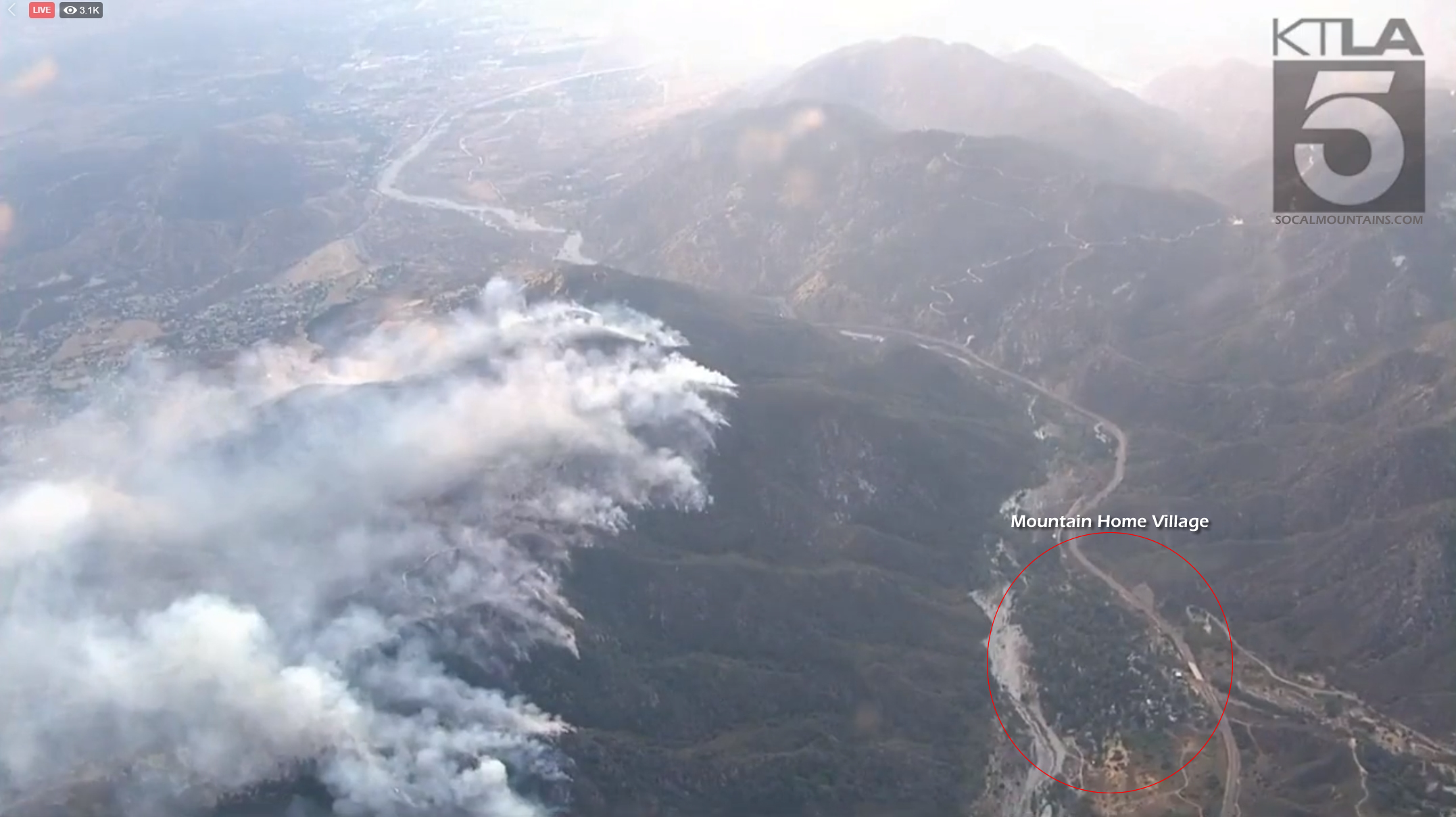
Re: EL DORADO FIRE Updates
SCM ALERT🚨, Sun Sep 06 2020, 06:52PM
INCIWEB EVENING UPDATE - SUN 9/6 @ 6:30pm
( Link: [Click Here] )
ACRES: 3010
CONTAINMENT: 5%
The El Dorado Fire started at approximately 10:30 a.m. on Saturday, September 5 at El Dorado Ranch Park in Yucaipa, Calif. The first engines on-scene reported several acres of fire with a Rapid Rate of Spread. The Fire was estimated at 3,010 acres with 5% containment. The fire burned actively overnight, and smoke will continue to impact portions of the Inland Empire today. The Southern California AQMD has issued a Smoke Advisory. Visit [Click Here] for air quality updates in your area.
Evacuations Orders (Mandatory)
Revised New Order - North Bench Yucaipa (All Resident north of Yucaipa Blvd, East of Bryant, and south of Hwy 38, and all residents North of Carter, west of Bryant, and South of Highway 38) )
- Evacuation Order: Oak Glen (partial, see road closures),
- Hwy 38 Area of Mountain Home Village and Forest Falls
A Red Cross reception site for evacuees is located at the Yucaipa Community Center, 34900 Oak Glen Rd, Yucaipa, CA 92399
San Bernardino County Residents: Sign up for San Bernardino County Telephone Emergency Notification System, by visiting [Click Here]
Road Closures
- Highway 38 at Bryant St. in Yucaipa and the community of Angelus Oaks
- Oak Glen Rd. between Pine Bench Rd. and Cherry Croft Dr.
- Bryant Street North of Yucaipa Blvd.
There is a soft closure on Highway 38 at Lake Williams Dr. (south of Big Bear, CA) to warn drivers of the closure in Angelus Oaks
Recreation Closures
- All San Gorgonio Wilderness, Trails, Trailheads and associated Parking Lots Except for the Pacific Crest Trail remains open.
- Other Trails: Big Falls, Oak Glen Divide, Wilson Creek
- Picnic Areas: Falls and Thurman Flats
- General Areas: Yucaipa Ridge, Mill Creek drainage and off-trail areas of the San Gorgonio Wilderness south of the San Bernardino Peak Divide Trail, Santa Ana River Trail between 1S14 and Middle Control Road.
- Thomas Hunting Grounds Yellow Post Sites
- Forest Roads: 1N12 (Near Angelus Oaks), 1S12 (Warm Springs Road), 1S13 and 1S03
Unified Command Partners
- CAL FIRE BDU
- San Bernardino County Fire
- San Bernardino County Sheriff's Department
- California Highway Patrol
- City of Yucaipa
- San Bernardino National Forest
Aviation and Drone Safety:
The FAA has issued a Safety No Fly Zone for civilian aircraft around the El Dorado Fire. Restricted Air Space is 5 Nautical Mile Radius from the Fire, and below 10,000 feet. This includes all types of personal hobby drones. Remember, If you Fly, We Cant! For specifics, please visit the FAA NOTAM Webpage.
Incident Information
Basic Information
Current as of 9/6/2020, 6:23:28 PM
Incident Type Wildfire
Cause Under Investigation
Date of Origin Saturday September 05th, 2020 approx. 10:30 AM
Location Yucaipa Ridge area, West Oak Glen, San Bernardino Mountains
Incident Commander Fogle with CA Interagency Incident Management Team 11
Coordinates 34.053 latitude, -116.992 longitude
Current Situation
Total Personnel 600
Size 3,010 Acres
Percent of Perimeter Contained 5%
Fuels Involved
Grass and Chaparral transitioning to timber in higher elevations
Outlook
Planned Actions
Engines will provide structure defense in the communities that are impacted by the fire. Other resources will work on perimeter control supported by the air assets.
Re: EL DORADO FIRE Updates
Mtngoat John⭐, Mon Sep 07 2020, 07:15AM
El Dorado, Vegetation Fire, San Bernardino County, Update
Oak Glen Rd x Potato Canyon Rd, west of Oak Glen
Federal/State/Local DPA, FRA/SRA/LRA, San Bernardino National Forest, San Bernardino Unit, Yucaipa Fire Department
7,386 acres (+336 acres), grass and brush, 7% contained (+2% containment)
Active fire behavior with running, flanking and group torching
Structures remain threatened
Evacuation orders in place
Road closures in the area
Red Flag warning in place, and an excessive heat waring remains in effect until 8pm Monday
Threat remains to communities of Oak Glen, Mountain Home Village, Forest Falls and City of Yucaipa
Threat to the San Gorgonio Wilderness including the Pacific Crest Trail and will impact Class 1 airshed
Threat to power grid infrastructure and hydroelectric power plant and apple orchards in Oak Glen
Damage inspection team in place
FMAG application approved
Unified command with USFS and CAL FIRE and Yucaipa Fire Department
CAIIMT 11 (Fogle) in command
Federal air and ground resources assigned
Re: EL DORADO FIRE Updates
Spiceguy , Mon Sep 07 2020, 08:22AM
Entire state covered in smoke.
Re: EL DORADO FIRE Updates
HazMatMind, Mon Sep 07 2020, 08:26AM
MSNBC just said El Dorado started at a gender reveal party. People, sigh.
Re: EL DORADO FIRE Updates
Deb Doodah, Mon Sep 07 2020, 10:19AM
Copying into the thread so that it doesn't disappear.
Posted in chat by Johnny U. on Monday 07 September 2020 - 08:43:02
A short smoky vid of the Eldorado fire from F-F. Today, 9/7/20, 7 A.M. [Click Here]
Re: EL DORADO FIRE Updates
SCM ALERT🚨, Mon Sep 07 2020, 03:53PM
[TIMELAPSE] EL DORADO FIRE MONDAY 9/7
Timelapse of the El Dorado Fire from the BensWeather SANG Camera. Covers Today from 12am to 2pm.
You can see some flare ups overnight as well as a big one around 7am.
Re: EL DORADO FIRE Updates
SCM ALERT🚨, Mon Sep 07 2020, 04:45PM
EL DORADO FIRE PHOTOS
PHOTOS BELOW CONTRIBUTED BY SCM MEMBER KRAZYKRISTEN WHO IS IN FOREST FALLS
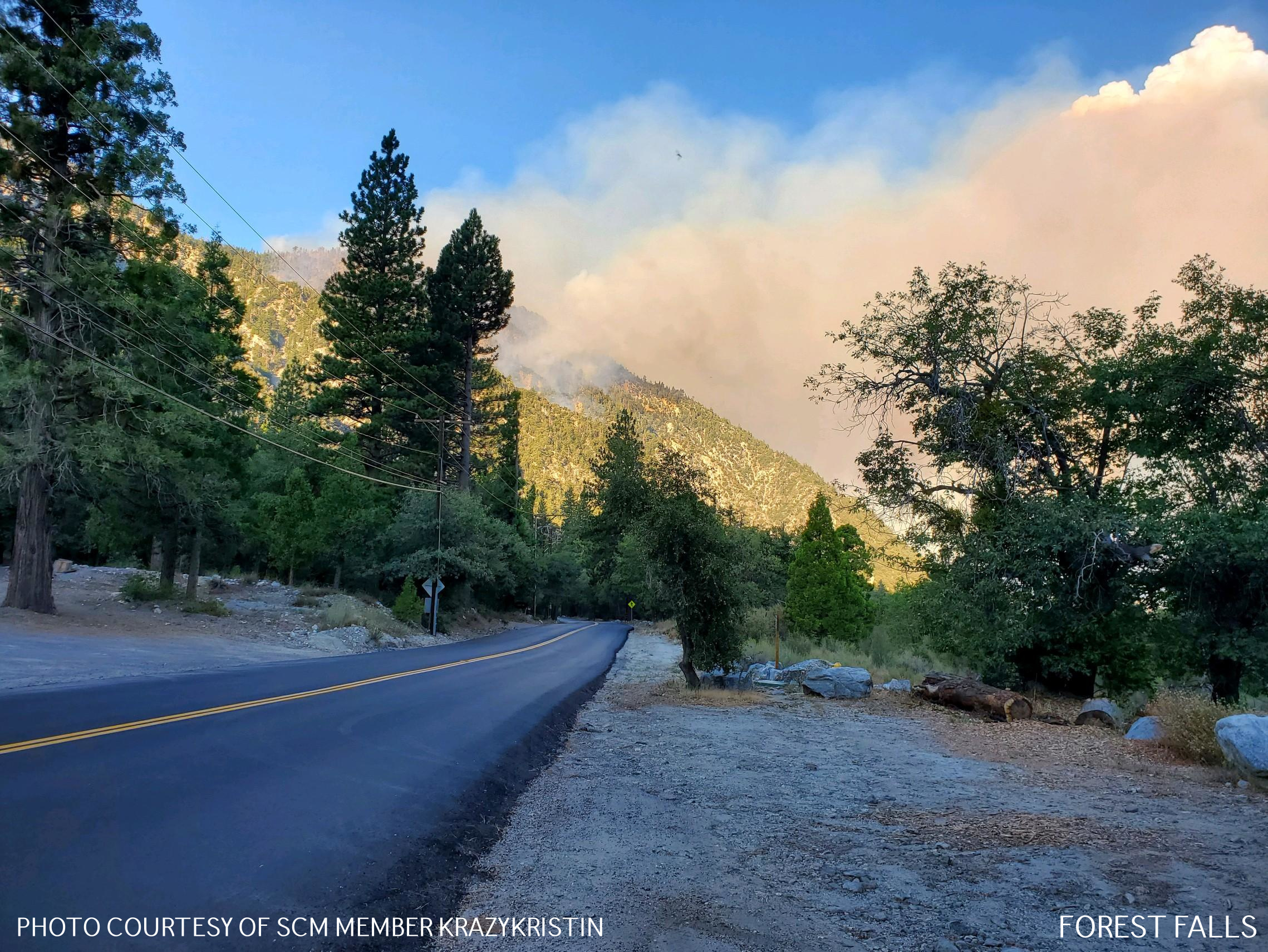


Re: EL DORADO FIRE Updates
SCM ALERT🚨, Mon Sep 07 2020, 04:45PM
EL DORADO FIRE PHOTOS
PHOTOS BELOW CONTRIBUTED BY SCM MEMBER KRAZYKRISTEN WHO IS IN FOREST FALLS
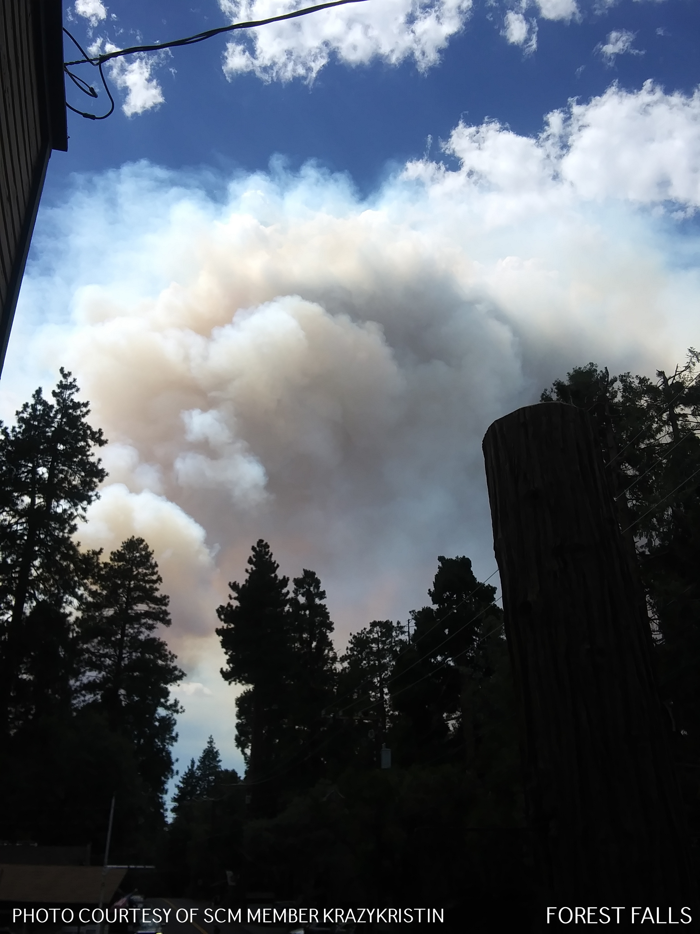
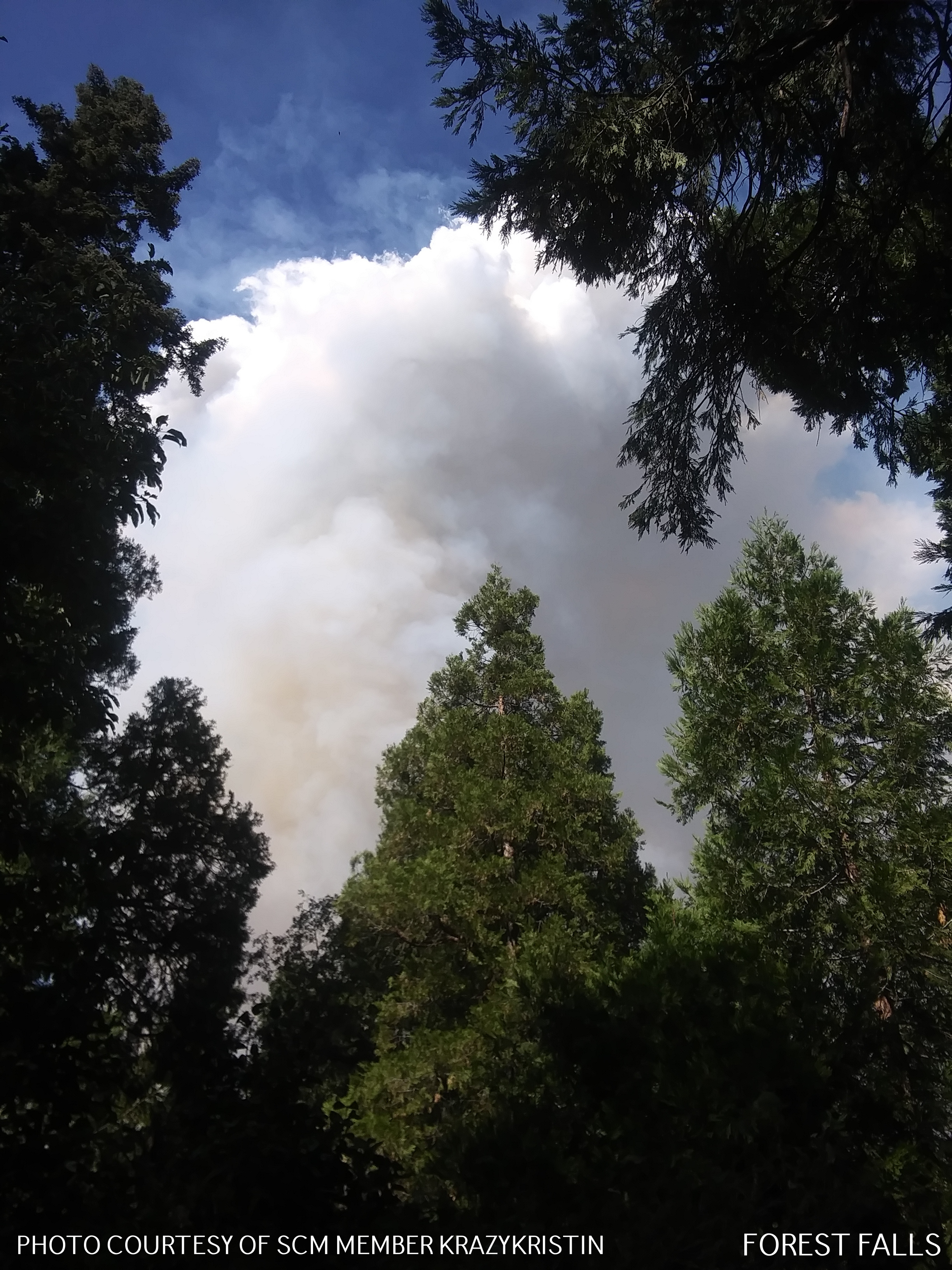

Re: EL DORADO FIRE Updates
SCM ALERT🚨, Mon Sep 07 2020, 04:46PM
EL DORADO FIRE PHOTOS
PHOTOS BELOW CONTRIBUTED BY SCM MEMBER KRAZYKRISTEN WHO IS IN FOREST FALLS
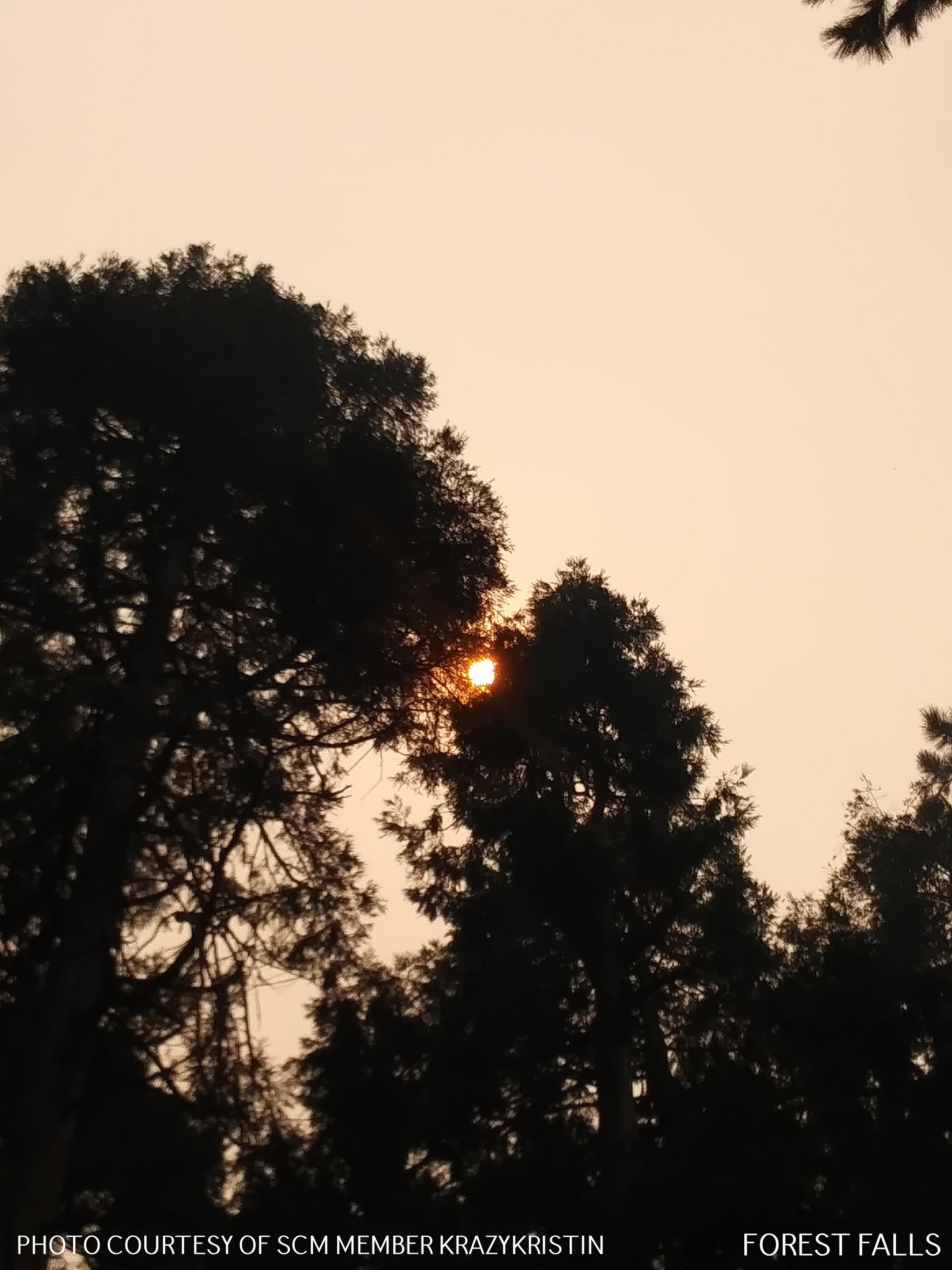
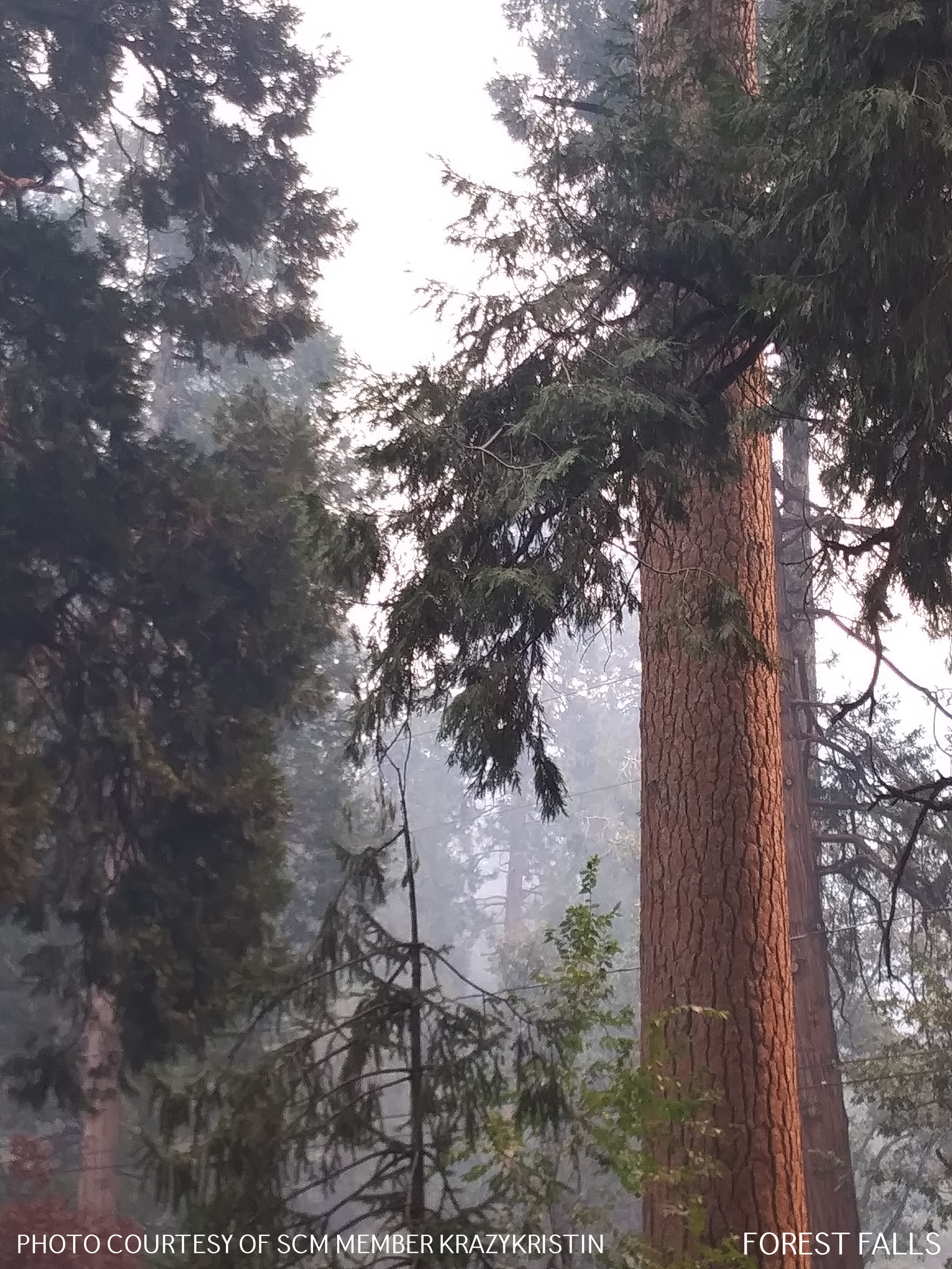
Re: EL DORADO FIRE Updates
furrymurry8114, Mon Sep 07 2020, 04:58PM
From the southern tip of Angelus Oaks looking down towards MHV.
trim.4bbe12b0-859c-4a0a-8e18-f2045f404dfd.movRe: EL DORADO FIRE Updates
SCM ALERT🚨, Mon Sep 07 2020, 05:27PM
Thank you for sharing that Video Furry! Definitely looks scary! (Also great to hear from you!).
Re: EL DORADO FIRE Updates
SCM ALERT🚨, Mon Sep 07 2020, 11:08PM
MON EVENING (9/7) 11PM - EL DORADO FIRE UPDATE
Good progress was made today. Firefighters were able to put black line around Mountain Home Village to protect homes. A burnout operation was also conducted on the eastern fire perimeter.
Current Conditions:
Firefighters made good progress on the El Dorado Fire today. There was no major wind event during the day. Firefighters were able to put black line around the Mountain Home community in the Mill Creek drainage to protect homes as the fire burns downslope on this northern perimeter. A burnout operation was also conducted on the eastern fire perimeter, between Oak Glen Road and the Apple Fire burn scar. The strategy in this area is to clear the vegetation to prevent the fire from escaping and moving towards homes.
On the north side of Yucaipa Ridge, the fire activity remains much calmer and crews are working on holding the fire at the Mill Creek wash along Hwy 38 at Mountain Home Village and into Forest Falls. The hard work of crews on the ground, dozers and aircraft have enabled a lot of great work to be accomplished as fire lines continue to be constructed around the fire in preparation for the upcoming Red Flag Santa Ana Wind event starting at noon tomorrow and lasting through Wednesday.
The weather will remain dry and hot throughout the night. The fuels remain receptive to burning which creates a potential for large fire movement.
Residents, please heed evacuation orders, please stay out of the fire area. The Red Cross Temporary Evacuation Point has been moved to the cafeteria at Redlands East Valley High School 31000 E. Colton Ave in Redlands.
CLOSURES AND EVACUATIONS
ROAD CLOSURES:
• Highway 38: Northbound Highway 38 is closed at Bryant Ave. and Southbound Highway 38 is closed at the town of Angelus Oaks.
• Oak Glen Road: Closed at Pine Bench Rd on the east and Cherry Croft/Jefferson on the west.
EVACUATIONS:
Evacuation Order: Yucaipa Blvd at Bryant intersection to the east. Yucaipa Blvd to Ave E southeast to the intersection of Mesa Grande, east to Wildwood Canyon Rd to include all portions of Hidden Meadows and the southern portion of the Cherry Valley Community from Nancy Lane east to Beaumont Ave. Including portions of Riverside County down to Orchard St.
Oak Glen (partial, see road closures), Mountain Home Village, Forest Falls and North Bench Yucaipa (north of Carter St to Highway 38 and both sides of Bryant St east & west).
Evacuation Warning: Evacuation warning in place for Beaumont Ave east to Hillside Place in the Highland Springs area to the Apple Fire burn perimeter to the north and Cherry Valley Blvd to the south.
SAN BERNARDINO NATIONAL FOREST RECREATION CLOSURES:
The entire Forest was closed to all public use at 5PM today. Please see [Click Here] for more information.
Re: EL DORADO FIRE Updates
Hooky Bobber, Tue Sep 08 2020, 05:58AM
9.8.2020
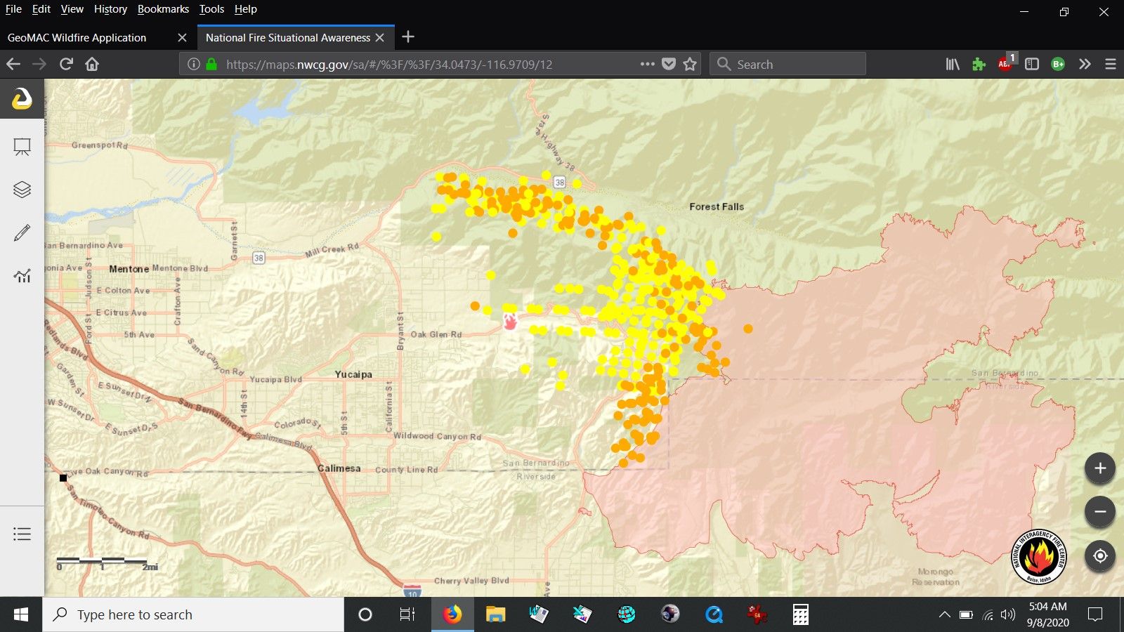
Re: EL DORADO FIRE Updates
AudioGuy, Tue Sep 08 2020, 09:46AM
Good grief, that map makes it look like Oak Glen and Mountain Home got it. But it hasn't???
Re: EL DORADO FIRE Updates
Jellylorum, Tue Sep 08 2020, 11:07AM
I saw an interview yesterday with the owner(?) of Oak Tree Village. The fire was very close, it got one of their barns, but the other buildings are OK.
Re: EL DORADO FIRE Updates
SCM ALERT🚨, Tue Sep 08 2020, 12:50PM
DORADO FIRE - UPDATED FIRE MAP TUE 9-8-2020
[Click to Enlarge]

Re: EL DORADO FIRE Updates
springvalley, Wed Sep 09 2020, 08:50AM
I'm kind of curious - do they consider the apple fire perimeter to be part of the "Containment"? or, is Containment (19%) just the parts of the fire that have some bureaucratic specified conditions achieved? One version would make the containment much higher (19%) PLUS the apple fire scar - where the fire's not going anywhere but has no official line around that portion....
Re: EL DORADO FIRE Updates
Mtngoat John⭐, Wed Sep 09 2020, 02:43PM
To answer the question posed in chat regarding dozer lines in Forest Falls, there are none. This mornings Incident Action Plan map.
Click image to enlarge
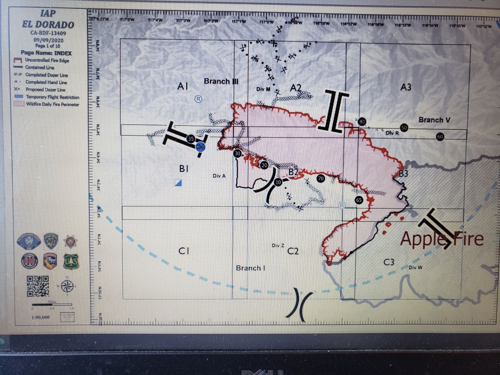
Re: EL DORADO FIRE Updates
Mtngoat John⭐, Wed Sep 09 2020, 07:40PM
Update
12,474 acres and now 18% containment
El Dorado, Vegetation Fire, San Bernardino County, Update
Oak Glen Rd x Potato Canyon Rd, west of Oak Glen
Federal/State/Local DPA, FRA/SRA/LRA, San Bernardino National Forest, San Bernardino Unit, Yucaipa Fire Department
12,474 acres (+995 acres), grass and brush, 18% contained (-1% containment)
Active fire behavior with backing, flanking, and creeping
Structures remain threatened
Evacuation orders remain in place
Fire has spotted over Hwy 38 and become well established below Angelus Oaks
Threat to communities of Angelus Oaks, Forest Falls, Yucaipa, Mountain Home Village, Pinezanita, Glen Martin School, Mile High Ranch, Pine Mtn Bench and apple orchards in Oak Glenn
Continued threat to cultural resources, critical infrastructure, commercial buildings, critical habitats and endangered species
Threat to the San Gorgonio Wilderness including the Pacific Crest Trail and will impact Class 1 airshed
Vegetation is critically dry and receptive to spotting
Fire is burning in steep, rugged and in-assessible terrain
Damage inspection is ongoing
Red flag warning in effect for next 12 hours, due to Santa Ana conditions with wind gusts of 25-40 mph
Road closures in area
Unified command with USFS, CAL FIRE, Yucaipa Fire Department and San Bernardino County Fire
CAIIMT 11 (Fogle) in command
Federal air and ground resources assigned
Re: EL DORADO FIRE Updates
Mtngoat John⭐, Thu Sep 10 2020, 06:57AM
Last nights IR mapping
Click image to enlarge

Re: EL DORADO FIRE Updates
SCM ALERT🚨, Thu Sep 10 2020, 07:14AM
EL DORADO FIRE INCIWEB UPDATE
THURSDAY 9/10 AT 7AM
EVACUATION ORDERS
- Areas east of Bryant from Highway 38 South to Yucaipa Blvd, then east on Yucaipa Blvd at Bryant intersection to Freemont Street, then South to Grande View Drive, then along Ave E southeast to the intersection of Mesa Grande, east to Wildwood Canyon Rd to include all portions of Hidden Meadows, and east to Edgar Canyon Road.
- The portion of the Cherry Valley Community that is north of Orchard St to the County Line , and East of Nancy Ave. and west of Beaumont Ave..
- Oak Glen (partial, see road closures), Mountain Home Village and Forest Falls
- New - All residents located North of Valley of the Falls Drive along Highway 38 to Onyx Summit, including the Angelus Oak, 7 Oaks and Jenks Lake Area. You must drive North to Big Bear, CA as Highway 38 is impacted by fire. Rock slides are also being reported along Highway 38 where the fire has loosened rocks.
Evacuation Warning (yellow) - Voluntary, but you should be prepared to leave at any time.
- Evacuation warning in place for east of Beaumont Ave east to Hillside Place in the Highland Springs area , North to Cherry Valley Blvd to the County Line Road.
- North of Oak Glen Road, West of Bryant, South of Highway 38, East of Garnet. Those who require additional time to evacuate, and those with pets and livestock should leave now.
A Red Cross reception site has moved. It is now located in the cafeteria of the Redlands East Valley High School, 31000 E. Colton Ave. Redlands
Emergency Notification Systems:
San Bernardino County Assistant Fire Chief Kat Opliger talks about the importance of the Telephone Emergency Notification System (TENS) in helping San Bernardino County manage evacuation notifications during fires and other emergencies.
San Bernardino County Residents: Sign up for San Bernardino County Telephone Emergency Notification System, or call 1-888-435-7565.
Riverside County Residents: Sign up for the Riverside County Swift911 System. Visit [Click Here] for updated information and preparedness information.
Road Closures:
- Highway 38 between Bryant St. in Yucaipa and Sugar Pine Drive in the community of Angelus Oaks
- Bryant Street Between Hwy 38 and Carter Street.
- Oak Glen Rd. between Pine Bench Rd. and Cherry Croft Dr.
- Cross Streets East of Bryant Street Between Yucaipa Blvd. and Carter St.
- Wildwood Canyon Drive between Mesa Grande and Oak Glen Road.
There is a soft closure on Highway 38 at Lake Williams Dr. (south of Big Bear, CA) to warn drivers of the closure in Angelus Oaks
Forest Closure Order of 8 National Forests:
As of 5:00 PM on Monday, September 7, the Regional Forester is closing 8 National Forests in Southern California, including the San Bernardino National Forest. This means the National Forest is temporarily closed to ALL public use due to the threat from high fire danger and firefighting resources being spread stretched to the limit. This includes driving Forest Roads, Hiking on Forest Trails, and being in any Forest Service Developed Recreation Areas. Please take the time to read and understand the Regional Forester's Decision Letter, and view the Forest Closure Order. This order will be reviewed daily.
Unified Command Partners
- CAL FIRE BDU
- San Bernardino County Fire
- San Bernardino County Sheriff's Department
- California Highway Patrol
- City of Yucaipa
- San Bernardino National Forest
Aviation and Drone Safety:
The FAA has issued a Safety No Fly Zone for civilian aircraft around the El Dorado Fire. Restricted Air Space is 5 Nautical Mile Radius from the Fire, and below 10,000 feet. This includes all types of personal hobby drones. Remember, If you Fly, We Cant! For specifics, please visit the FAA NOTAM Webpage.
Incident Information
Basic Information
Current as of 9/10/2020, 6:42:49 AM
Incident Type Wildfire
Cause Human Caused
Date of Origin Saturday September 05th, 2020 approx. 10:30 AM
Location Yucaipa Ridge area, West Oak Glen, San Bernardino Mountains
Incident Commander C. Fogle, CA Interagency Incident Management Team 11 and numerous cooperators in Unified Command.
Coordinates 34.053 latitude, -116.992 longitude
Current Situation
Total Personnel 1,244
Size 12,610 Acres
Percent of Perimeter Contained 23%
Fuels Involved
Grass and Chaparral transitioning to timber in higher elevations
Significant Events
Fire continued to grown on the steep terrain with moderate uphill runs and short range spotting.
Outlook
Planned Actions
Crews and dozers will continue to build direct line around the fire to limit spread to the north and west towards Angelus Oaks. Aircraft will be supporting direct line construction and contingency work. Defensive burnout operations could continue as needed. Resources will be working to mop up and secure other of the fire areas in and around structures. Engines will also provide structure defense in the community's that are impacted by the fire.
Current Weather
Developing high pressure over California and Nevada will bring a slow warming trend through Monday. Patchy night and morning low clouds and fog near the coast will become a little more widespread over the weekend. Toward the middle of next week, a trough of low pressure to the northwest will begin to strengthen the onshore flow and spread slow cooling inland. High pressure aloft over California and Nevada should bring a slow warming trend for Friday through Monday. There will be some return today of the smoke aloft from the fires in northern and central California in addition to the smoke from the fires in southern California in Los Angeles and San Bernardino Counties. This could reduce temperatures a few degrees from what would otherwise occur absent the smoke aloft.
Re: EL DORADO FIRE Updates
Mtngoat John⭐, Thu Sep 10 2020, 07:39AM
El Dorado, Vegetation Fire, San Bernardino County, Update
Oak Glen Rd x Potato Canyon Rd, west of Oak Glen
Federal/State/Local DPA, FRA/SRA/LRA, San Bernardino National Forest, San Bernardino Unit, Yucaipa Fire Department
12,610 acres (+136 acres), grass and brush, 23% contained (5% containment)
Active fire behavior with backing, flanking, and creeping
Structures remain threatened
Evacuation orders remain in place
Fire has spotted over Hwy 38 and become well established below Angelus Oaks
Threat to communities of Angelus Oaks, Forest Falls, Yucaipa, Mountain Home Village, Pinezanita, Glen Martin School, Mile High Ranch, Pine Mtn Bench and apple orchards in Oak Glenn
Continued threat to cultural resources, critical infrastructure, commercial buildings, critical habitats and endangered species
Threat to the San Gorgonio Wilderness including the Pacific Crest Trail and will impact Class 1 airshed
Vegetation is critically dry and receptive to spotting
Fire is burning in steep, rugged and in-assessable terrain
Damage inspection is ongoing
Red flag warning remain in effect for dry conditions with possible gusting winds
Road closures in area
Unified command with USFS, CAL FIRE, Yucaipa Fire Department and San Bernardino County Fire
CAIIMT 11 (Fogle) in command
Federal air and ground resources assigned
Re: EL DORADO FIRE Updates
Mtngoat John⭐, Thu Sep 10 2020, 08:08AM
Briefing map 9-10-2020
Click image to enlarge

Re: EL DORADO FIRE Updates
SCM ALERT🚨, Thu Sep 10 2020, 10:44AM
FIRE PERIMETER MAP - MTN HOME VILLAGE 9-10-20
(click to enlarge)
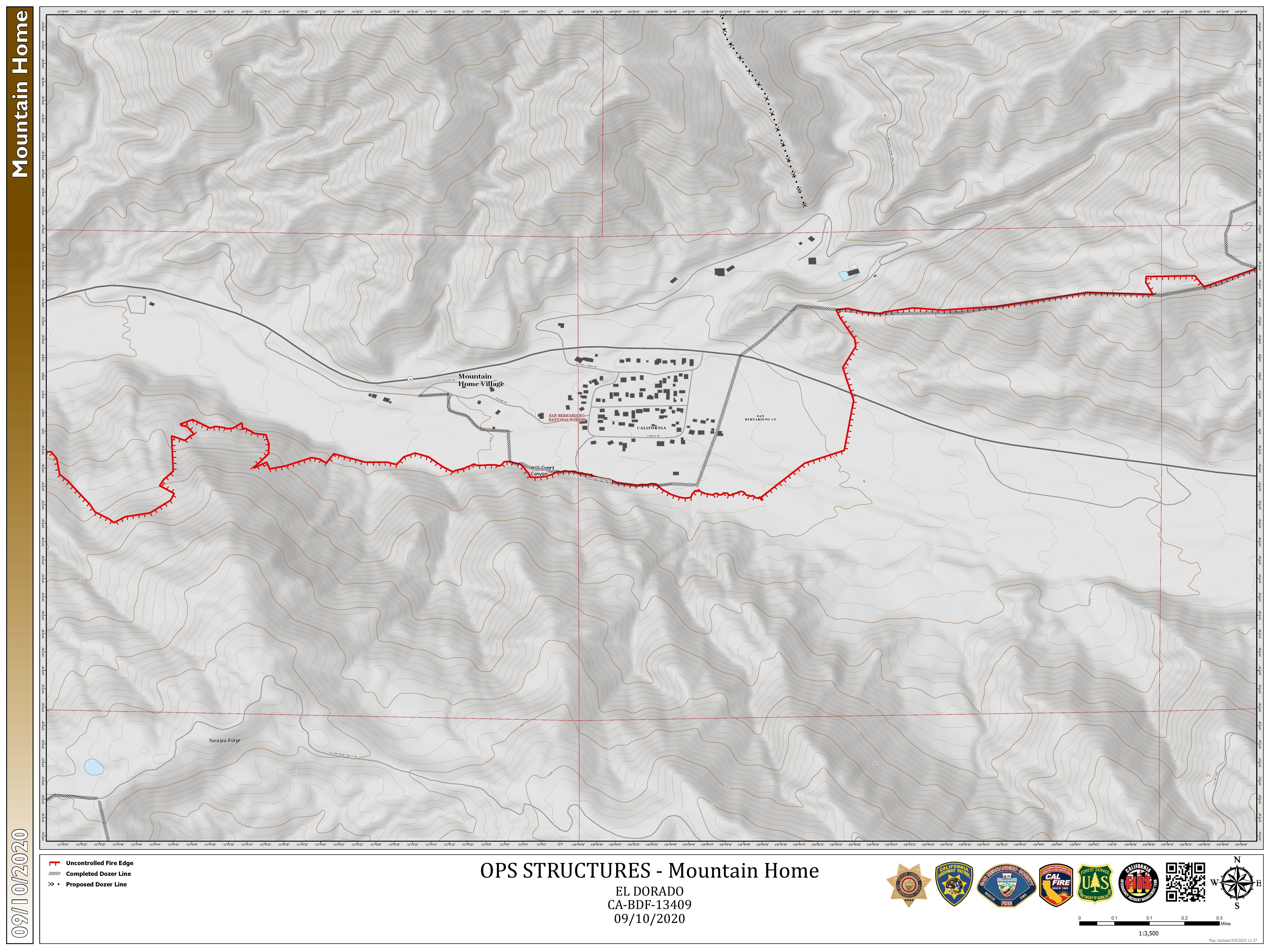
Re: EL DORADO FIRE Updates
SCM ALERT🚨, Thu Sep 10 2020, 10:45AM
FIRE PERIMETER MAP - FOREST FALLS 9-10-20
(click to enlarge)
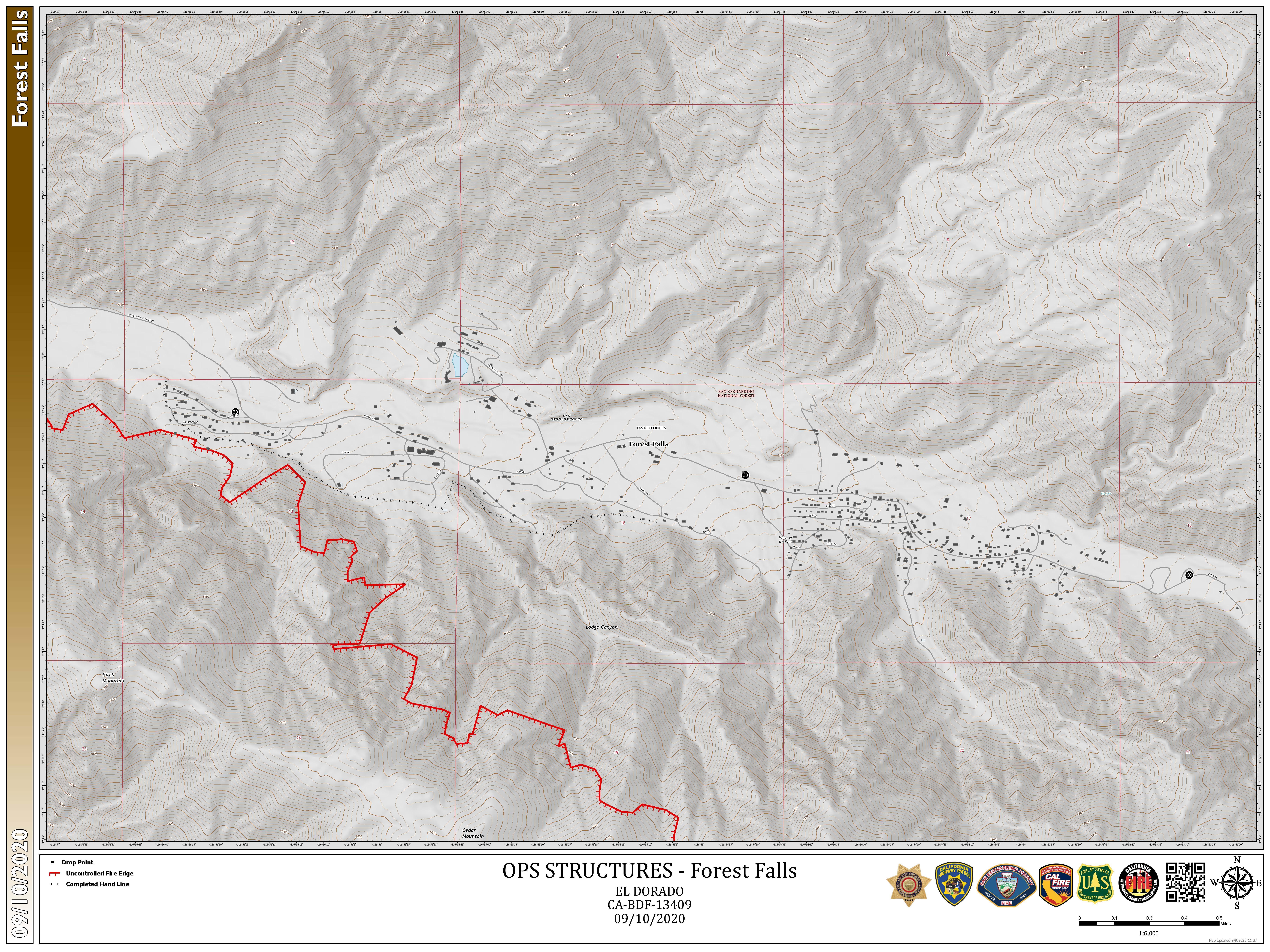
Re: EL DORADO FIRE Updates
©ammy, Thu Sep 10 2020, 09:24PM
At least 5 dozers out working tonight. This is the Oaks Restaurant parking lot in Angelus Oaks:
Re: EL DORADO FIRE Updates
BBNona, Fri Sep 11 2020, 07:36AM
God bless our firemen...amazing how all the work they did protected Mtn home Village & Forest Falls. Looking at the fire map is you can see how it just missed both communities.
Re: EL DORADO FIRE Updates
Mtngoat John⭐, Fri Sep 11 2020, 07:52AM
This mornings briefing map
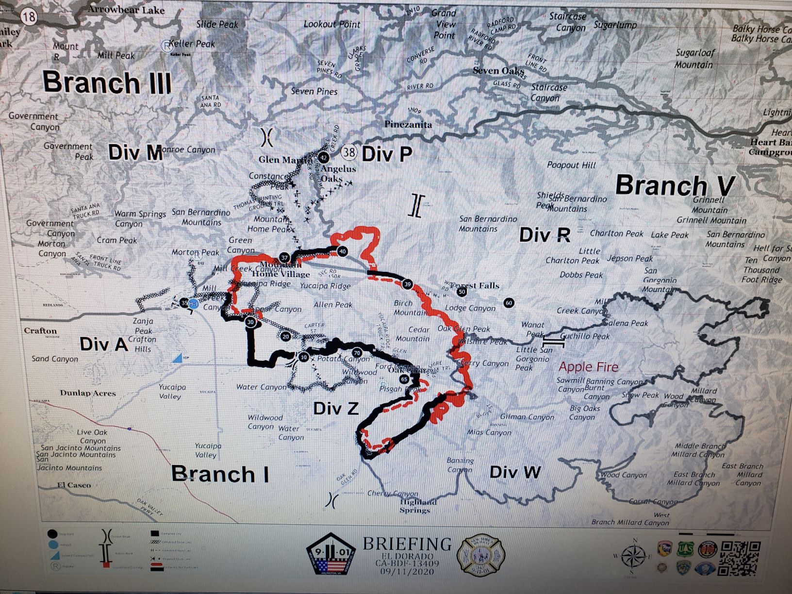
Re: EL DORADO FIRE Updates
Mtngoat John⭐, Fri Sep 11 2020, 07:53AM
IR Mapping from last night
Click image to enlarge
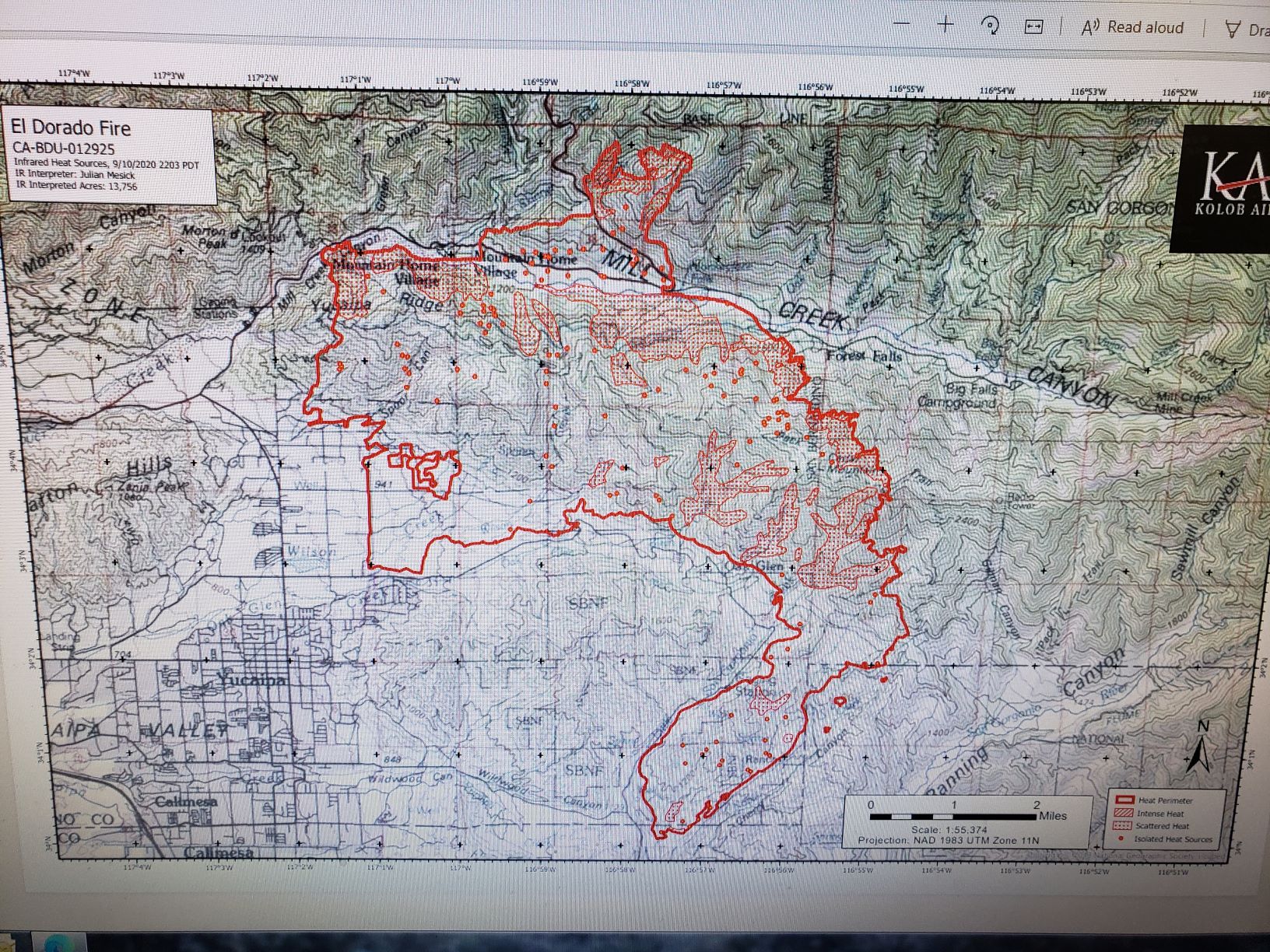
Re: EL DORADO FIRE Updates
Mtngoat John⭐, Fri Sep 11 2020, 07:57AM
El Dorado, Vegetation Fire, San Bernardino County, Update
Oak Glen Rd x Potato Canyon Rd, west of Oak Glen
Federal/State/Local DPA, FRA/SRA/LRA, San Bernardino National Forest, San Bernardino Unit, Yucaipa Fire Department
13,715 acres (+123 acres), grass and brush, 31% contained (+0% containment)
Active fire behavior with flanking, single tree torching, and backing
Structures remain threatened
Evacuation orders remain in place
Fire is burning north of Hwy 38 above Mountain Home Village and Forest Falls and is well established
Threat to communities of Angelus Oaks, Forest Falls, Yucaipa, Mountain Home Village, Pinezanita, Glen Martin School, and scattered outbuildings
Continued threat to numerous cultural resources, critical infrastructure (including cell towers, radio towers, transmission lines, phone lines and transportation corridors), critical habitat for threatened and endangered species, Inventoried Roadless areas, San Gorgonio Wilderness including the Pacific Crest Trail
Vegetation is critically dry and receptive to spotting
Fire is burning in steep, rugged and in-assessable terrain
Damage inspection is ongoing
Road closures in area
Unified command with USFS, CAL FIRE, Yucaipa Fire Department and San Bernardino County Fire
CAIIMT 11 (Fogle) in command
Re: EL DORADO FIRE Updates
Deb Doodah, Fri Sep 11 2020, 11:05AM
Good Video Link....
Sep 11 : 10:35am
That is a great link for a first hand look! Thank you Marty!
(I copied Marty's post again below in case you missed it)
Marty
Sep 11 : 09:39am
The drive from Angelus Oaks to Forest Falls, 9/10/20.
[Click Here]
McToddy
Sep 11 : 11:01am
Here's a link to Marty's Part 2 video
[Click Here]
Re: EL DORADO FIRE Updates
AudioGuy, Fri Sep 11 2020, 11:53AM
Those links aren't "clickable"... at least not for me. Maybe check your embedded code for a mistake?
Re: EL DORADO FIRE Updates
Benny ⭐, Fri Sep 11 2020, 11:56AM
Something you don't see every day, while smoke covers the entire state, it's also wrapped off the west coast and wound into low pressure 1500 miles offshore. Even reaching up near the Aleutian islands! Expect similar conditions through the weekend with a gradual warm-up, winds will remain mostly light and variable.
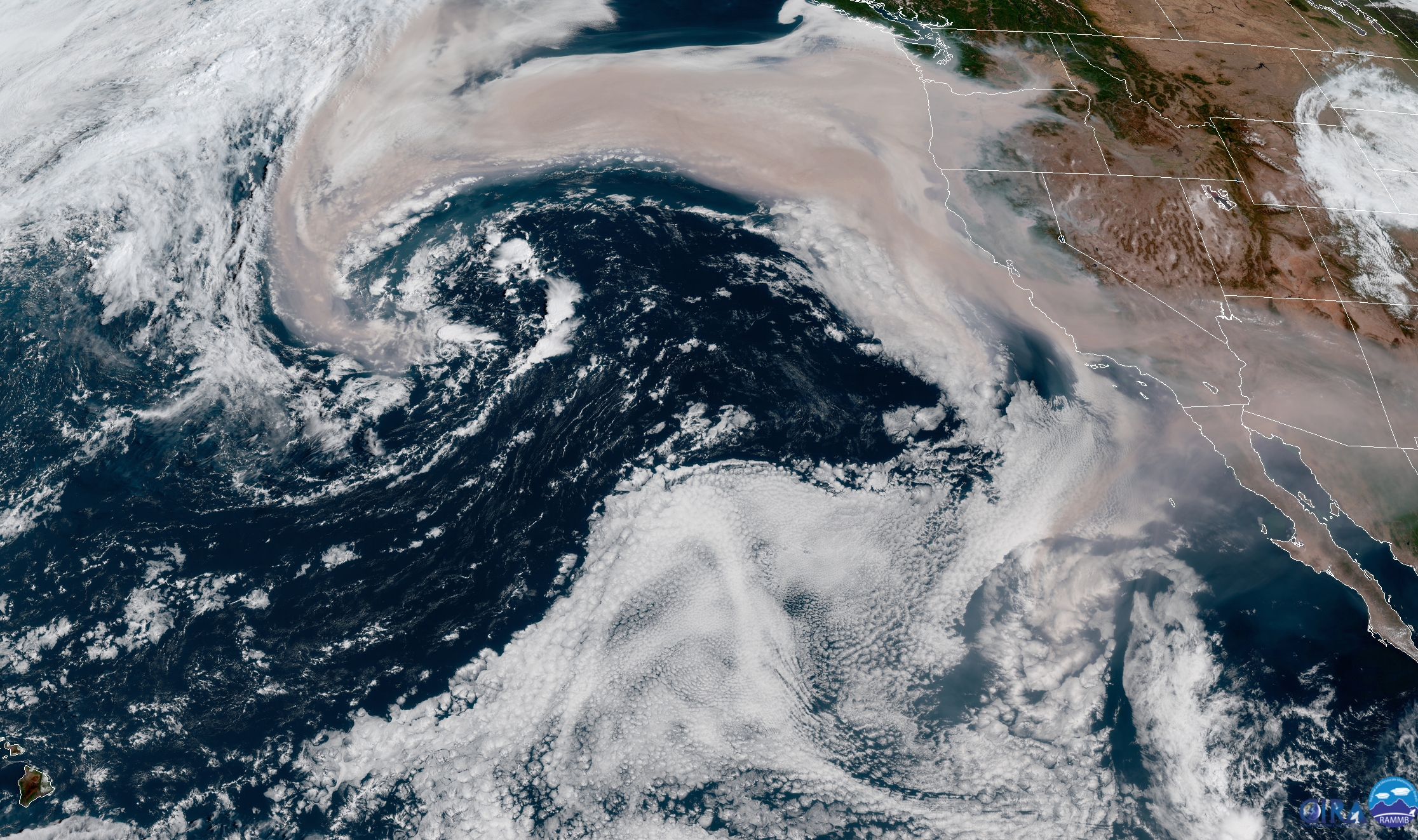
Re: EL DORADO FIRE Updates
Mtngoat John⭐, Fri Sep 11 2020, 07:17PM
El Dorado, Vegetation Fire, San Bernardino County, Update
Oak Glen Rd x Potato Canyon Rd, west of Oak Glen
Federal/State/Local DPA, FRA/SRA/LRA, San Bernardino National Forest, San Bernardino Unit, Yucaipa Fire Department
13,920 acres (+205 acres), grass and brush, 38% contained (+7% containment)
Active fire behavior with flanking, single tree torching, and backing
Structures remain threatened
Evacuation orders remain in place
Evacuations orders are now lifted for all areas east of Jefferson and south of Carter
The Oak Glen area will be open to residents, business owners and employees only
Fire is burning north of Hwy 38 above Mountain Home Village and Forest Falls and is well established
Threat to communities of Angelus Oaks, Forest Falls, Yucaipa, Mountain Home Village, Pinezanita, Glen Martin School, and scattered outbuildings
Continued threat to numerous cultural resources, critical infrastructure (including cell towers, radio towers, transmission lines, phone lines and transportation corridors), critical habitat for threatened and endangered species, Inventoried Roadless areas, San Gorgonio Wilderness including the Pacific Crest Trail
Fire is burning in steep, rugged and in-assessable terrain
Road closures in area
Unified command with USFS, CAL FIRE, Yucaipa Fire Department and San Bernardino County Fire
CAIIMT 11 (Fogle) in command
Re: EL DORADO FIRE Updates
SCM ALERT🚨, Fri Sep 11 2020, 09:02PM
EL DORADO FIRE
FRIDAY SUMMARY (9/11)
Friday summary: ground crews are making an incredible effort in containing the EL DORADO fire. On the northern portion of Yucaipa ridge fire crews have continued the hard work of building fire line to secure the perimeter and aggressively attacking the fire. Air resources have aided in the fire fight with continuous water and retardant drops throughout the day. Structure protection continues in mountain home village and forest falls with securing fire lines along the creek. The fire continues to progress slowly downslope as it moves laterally along the creek. This has allowed fire crews a good opportunity to continue to prepare the area with securing handlines and increasing defensible space. Dozer line has been established north of the fire perimeter and south of angelus oaks from hwy 38 eastward to the 2015 lake fire scar. Ground crews are actively working to secure the contingency line with hose line placement. Smoke continues to be seen over the wildwood canyon area from fuels burning inside of the perimeter posing minimal threat to the fire line. Crews are actively patrolling the southern portion of Yucaipa ridge and extinguishing hot spots and flare-ups.
The weather remains dry and hot with minimal relative humidity recovery overnight. The wind will transition to downslope tonight at 4 to 8 mph gusting to 12 mph. California has issued a fuels advisory for excessively dry fuels due to the lack of precipitation in the area and excessive temperatures throughout the state. This allows the potential for active terrain driven fire behavior as wind and topography align.
The San Bernardino County Sheriff’s Department and the El Dorado Fire Unified Incident Commanders continue the advisory for visitors to consider rescheduling planned visits to the Big Bear area due to fire activity.
Neighbors, please stay vigilant and check Inciweb, Twitter and Facebook for changes on the #ElDoradoFire. There are physical signboards at the Stater Bros. shopping center in Beaumont at 1430 Beaumont Ave., 1775 east Lugonia Ave. in Redlands near the Starbucks and 11365 Bryant St. Yucaipa in the Stater Bros shopping center.
ROAD CLOSURES:
• Highway 38 is closed between Bryant St. to the south and Lake Williams Dr. to the north
• Topaz St. is closed at Bryant St. to eastbound traffic
• Juniper Ave. is closed at Bryant St.
• Carter St. is closed between Bryant St. and Jefferson St.
• Ivy is closed between Bryant St. and Jefferson St.
• Oak Glen Rd. access to residents, businesses and business support services only between lower Potato Cyn Rd. and Pine Bench Rd.
• Fremont St is closed at Carter St.
EVACUATIONS:
Evacuation Orders:
The El Dorado Fire remains under an Evacuation Order in Yucaipa: the neighborhood bordered by Bryant St. on the west, Carter St. on the south, Jefferson St. on the east, and Hwy 38 to the north. Angelus Oaks, Forest Falls, and Mountain Home Village also remain under evacuation order.
Evacuation Warning:
For portions of Mentone and Yucaipa: the areas bounded by the following streets remain in an evacuation warning: North of Oak Glen Road, West of Bryant, South of Highway 38 and East of Garnet.
SAN BERNARDINO NATIONAL FOREST RECREATION CLOSURES:
The entire Forest was closed to all public use at 5 p.m. on Monday, Sept. 7. Please see [Click Here] for more information.
(fire operations map - click to enlarge)

(evacuations map - click to enlarge)
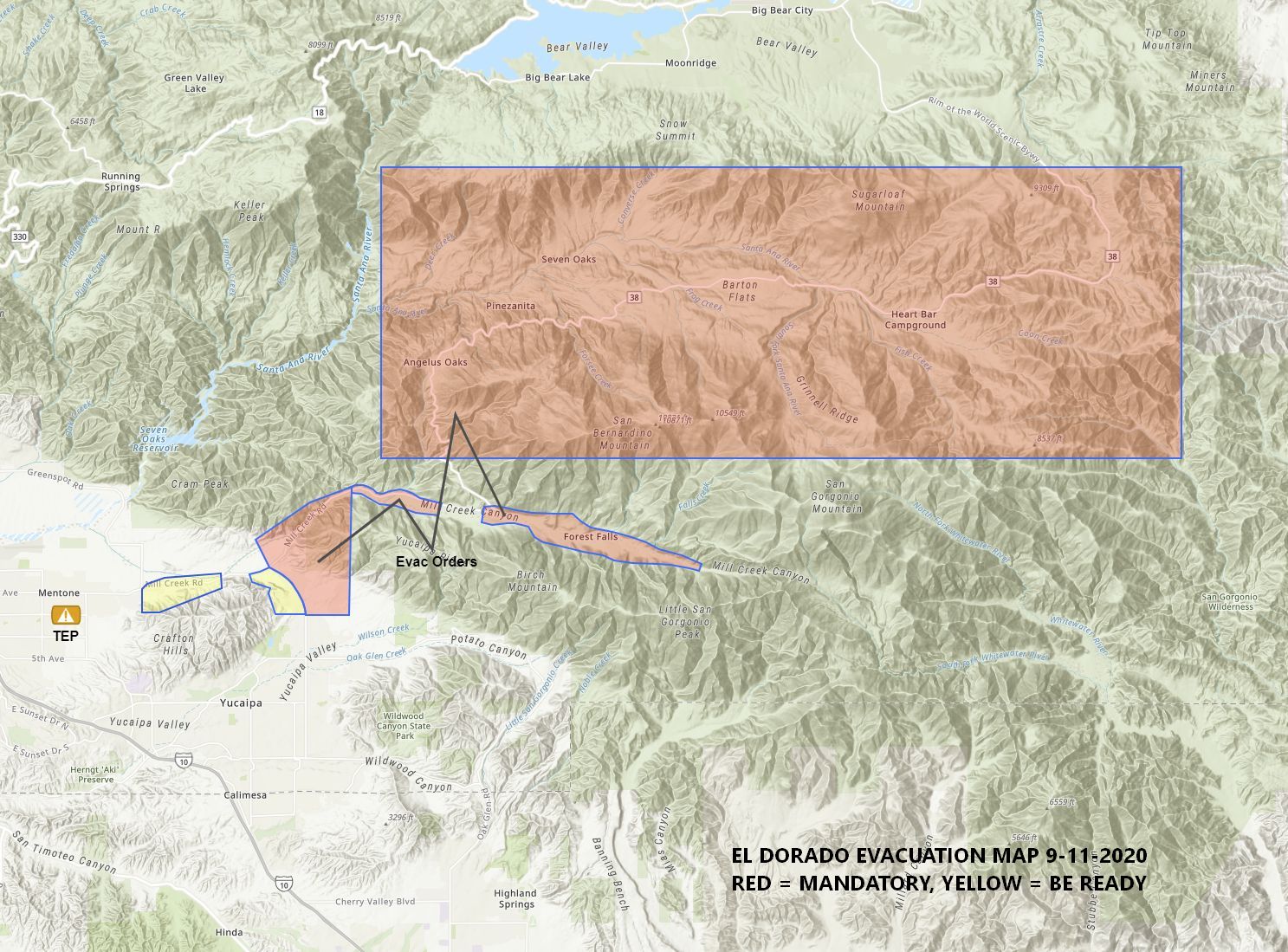
Re: EL DORADO FIRE Updates
Mtngoat John⭐, Sat Sep 12 2020, 07:59AM
El Dorado, Vegetation Fire, San Bernardino County, Update
Oak Glen Rd x Potato Canyon Rd, west of Oak Glen
Federal/State/Local DPA, FRA/SRA/LRA, San Bernardino National Forest, San Bernardino Unit, Yucaipa Fire Department
14,043 acres (+123 acres), grass and brush, 39% contained (+1% containment)
Active fire behavior with flanking, single tree torching, and backing
Structures remain threatened
Evacuation orders and warnings remain in place
Evacuations orders are now lifted for all areas east of Jefferson and south of Carter
The Oak Glen area will be open to residents, business owners and employees only
Fire is burning north of Hwy 38 above Mountain Home Village and Forest Falls and is well established
Threat to communities of Angelus Oaks, Forest Falls, Yucaipa, Mountain Home Village, Pinezanita, Glen Martin School, and scattered outbuildings
Continued threat to numerous cultural resources, critical infrastructure (including cell towers, radio towers, transmission lines, phone lines and transportation corridors), critical habitat for threatened and endangered species, Inventoried Roadless areas, San Gorgonio Wilderness including the Pacific Crest Trail
Fire is burning in steep, rugged and in-assessable terrain
Road closures in area
Unified command with USFS, CAL FIRE, Yucaipa Fire Department and San Bernardino County Fire
CAIIMT 11 (Fogle) in command
Re: EL DORADO FIRE Updates
SCM ALERT🚨, Sat Sep 12 2020, 06:49PM
[EL DORADO FIRE] FULL UPDATE - 7PM UPDATE SAT 9/12
Acres: 14,212
Containment: 41%
PLANNED ACTIONS:
Crews and dozers will continue to build direct line around the fire to limit spread to the north and west towards Angelus Oaks. Aircraft will be supporting direct line construction and contingency work. Defensive burnout operations could continue as needed. Resources will be working to mop up and secure other of the fire areas in and around structures. Engines will also provide structure defense in the community's that are impacted by the fire.
REMARKS
Fire is north of the Hwy 38 between Mountain Home Village and Forest Falls and continues to burn in Frustration Creek and Monkeyface Creek burning north towards San Bernardino Peak and west towards Mountain Home Creek in very steep and rugged terrain. Fire behavior has been active during both day and night operations, and continues to be push down the slopes driven by diurnal winds with moderate rates of spread. The lack of appropriate types of resources is making it difficult to gain containment or control of the incident. High temperatures and critically low fuel moisture's are also contributing to a very high resistance to control and limiting operational planning options.
EVACUATIONS
MANDATORY EVACUTIONS:
All Residents located East of Brant, North of Carter, and West of Jefferson remain in under an Evacuation Orders.
All residents located east of Bryant Street on Highway 38 including Mountain Home, Forest Falls, Angelus Oak, 7 Oaks and Jenks Lake Area East to Onyx Summit. Note: Angelus Oaks / Seven Oaks Residents, You must drive North to Big Bear, CA as Highway 38 is impacted by fire. Rock slides are also being reported along Highway 38 where the fire has loosened rocks.
EVACUATION WARNINGS (BE PREPARED)
North of Carter, West of Bryant, South of Highway 38, East of Garnet.
Big Bear residents, please monitor the El Dorado Fire and stay informed on fire conditions.
ROAD CLOSURES
Highway 38 is closed between Bryant St. and Lake Williams Dr.
Topaz St. is closed at Bryant St. to eastbound traffic
Juniper Ave and Adams Street are closed east of Bryant St.
Fremont St is closed north of Carter St.
Ivy is closed between Bryant and Jefferson.
[Webcam shot from Big Bear ~6:30pm]
[Fire Burn Map created by Bensweather]
SUMMARY
Ground crews continue to make an incredible effort in containing the El Dorado Fire. Overnight, fire conditions were calm and allowed for good progress on securing the fire line, particularly in the Mill Creek drainage area. The fire is aligning itself with Skinner Creek along Highway 38, east of Mountain Home Village. As the wind transitions to up canyon winds this afternoon, there is the potential for large fire growth as weather and terrain align. Ground crews continue securing fire lines and air resources are utilizing retardant and water drops to slow fire progression.
Dozer line has been established north of the fire perimeter and south of Angelus Oaks along Hwy 38 for structure protection. Hand line is being constructed eastward to the 2015 Lake Fire scar. Ground crews are actively working to secure the contingency line with hose line placement. The fire continues to slowly move laterally behind Forest Falls along the creek. Firefighting efforts continue as crews extend the fire line from Vivian Creek to the old Apple Fire scar and continued structure defense. Smoke continues to be seen over the Wildwood Canyon area from fuels burning inside of the perimeter posing minimal threat to the fire line.
The fire is currently estimated at 14,043 acres with 39% containment. Damage assessment teams have completed assessments in the Oak Glen Area. Residences: 4 destroyed, and 2 damaged; Minor structures/outbuildings: 6 destroyed, and 4 damaged.
Operations Chief Dan Munsey provides an Morning Video Update (9/12) on the El Dorado Fire.
Read the September 12, 2020 Morning Update.
View a Close-up Map of the Forest Falls Area (9/10, pdf) or the Map of the Mountain Home Area (9/10,pdf) There was no growth in the Mtn. Home Area, and limited growth near the Forest Falls Area.
SMOKE IMPACTS:
Smoke will continue to impact portions of the Inland Empire and the San Gorgonio Pass area today and tonight, although much of the smoke in the upper atmosphere is from fires in central California.. The Southern California AQMD has issued a Smoke Advisory due to smoke from the El Dorado Fire and the Bobcat Fire. Visit [Click Here] for air quality updates in your area.
A Red Cross is located at the Redlands East Valley High School, 31000 E. Colton Ave. Redlands.
ALL FOREST LAND WITHIN THE STATE OF CALIFORNIA IS *CLOSED*
As of 5:00 PM on Monday, September 7, the Regional Forester is closing 8 National Forests in Southern California, including the San Bernardino National Forest. This means the National Forest is temporarily closed to ALL public use due to the threat from high fire danger and firefighting resources being spread stretched to the limit. This includes driving Forest Roads, Hiking on Forest Trails, and being in any Forest Service Developed Recreation Areas. Please take the time to read and understand the Regional Forester's Decision Letter, and view the Forest Closure Order. This order will be reviewed daily.
Re: EL DORADO FIRE Updates
SCM ALERT🚨, Sun Sep 13 2020, 06:49PM
EL DORADO FIRE UPDATE - SUN 9/13 @ 6PM
Acres: 14,283
Containment: 44%
Personnel: 1,319
Injuries: 10
Evacuated: 7,236
Homes damaged: 2
Homes destroyed: 4
Outbuildings damaged: 4
Outbuildings destroyed: 6
SCM Incident Link: [Click Here]
INCIDENT NARRATIVE
Hotshot crews began direct line construction in the Skinner Creek area above Hwy 38. They are being supported by specialized hose lays that are refilled by helicopters into portable tanks. This is needed due to the elevation change and rugged topography. Dozer lines are established south of Angelus Oaks along Hwy 38 for community protection. Ground crews are actively constructing a contingency line between Hwy 38 and the 2015 Lake Fire burn scar. The fire continues to back downhill above Forest Falls. Crews worked to extend the fire line along Mill Creek to Mill Creek Jumpoff. They will also be looking for opportunities to connect natural barriers i.e. rocks and scree slopes to prevent fire movement eastward. Smoke will remain visible in the Yucaipa and Oak Glen areas as unburned fuels within the fire perimeter continue to burn. Fire crews continue to patrol this area.
SIGNIFICANT EVENTS
Fire continued to grow on the steep terrain with moderate uphill runs and short range spotting.
EVACUATION UPDATE
At 7:00 this morning, San Bernardino County Sheriffs and Yucaipa Police Department announced that all evacuation zones south of Highway 38 and east and west of Bryant Street are lifted. Residents and businesses owners are allowed to return. Please be aware that fire personnel will still be monitoring the area and completing any additional work that needs to be completed.
The area east of Bryant Street on Highway 38 REMAINS UNDER AN EVACUATION ORDER. This including Mountain Home, Forest Falls, Angelus Oak, 7 Oaks and Barton Flats / Jenks Lake Area east to Onyx Summit. BIG BEAR RESIDENTS: Please monitor the El Dorado Fire on social media and stay informed on fire conditions.
ROAD CLOSURES
Highway 38 is closed between Bryant St. and Lake Williams Dr.
FOREST CLOSURE ORDER
Forest Closure Order of 8 National Forests:
As of 5:00 PM on Monday, September 7, the Regional Forester is closing 8 National Forests in Southern California, including the San Bernardino National Forest. This means the National Forest is temporarily closed to ALL public use due to the threat from high fire danger and firefighting resources being spread stretched to the limit. This includes driving Forest Roads, Hiking on Forest Trails, and being in any Forest Service Developed Recreation Areas. Please take the time to read and understand the Regional Forester's Decision Letter, and view the Forest Closure Order. This order will be reviewed daily.
AVIATION SAFTEY
The FAA has issued a Safety No Fly Zone for civilian aircraft around the El Dorado Fire. Restricted Air Space is 5 Nautical Mile Radius from the Fire, and below 10,000 feet. This includes all types of personal hobby drones. Remember, If you Fly, We Cant! For specifics, please visit the FAA NOTAM Webpage.
PLANNED ACTIONS
Crews and dozers will continue to build direct line around the fire to limit spread to the north and west towards Angelus Oaks. Aircraft will be supporting direct line construction and contingency work. Defensive burnout operations could continue as needed. Resources will be working to mop up and secure other of the fire areas in and around structures. Engines will also provide structure defense in the community's that are impacted by the fire.
INCIDENT REMARKS
Fire is north of the Hwy 38 between Mountain Home Village and Forest Falls and continues to burn in Frustration Creek and Monkeyface Creek burning north towards San Bernardino Peak and west towards Mountain Home Creek in very steep and rugged terrain. Fire behavior has been active during both day and night operations, and continues to be push down the slopes driven by diurnal winds with moderate rates of spread. The lack of appropriate types of resources is making it difficult to gain containment or control of the incident. High temperatures and critically low fuel moisture's are also contributing to a very high resistance to control and limiting operational planning options.
[Photos: Caltrans continues work on damaged infrastructure]
[click to enlarge]
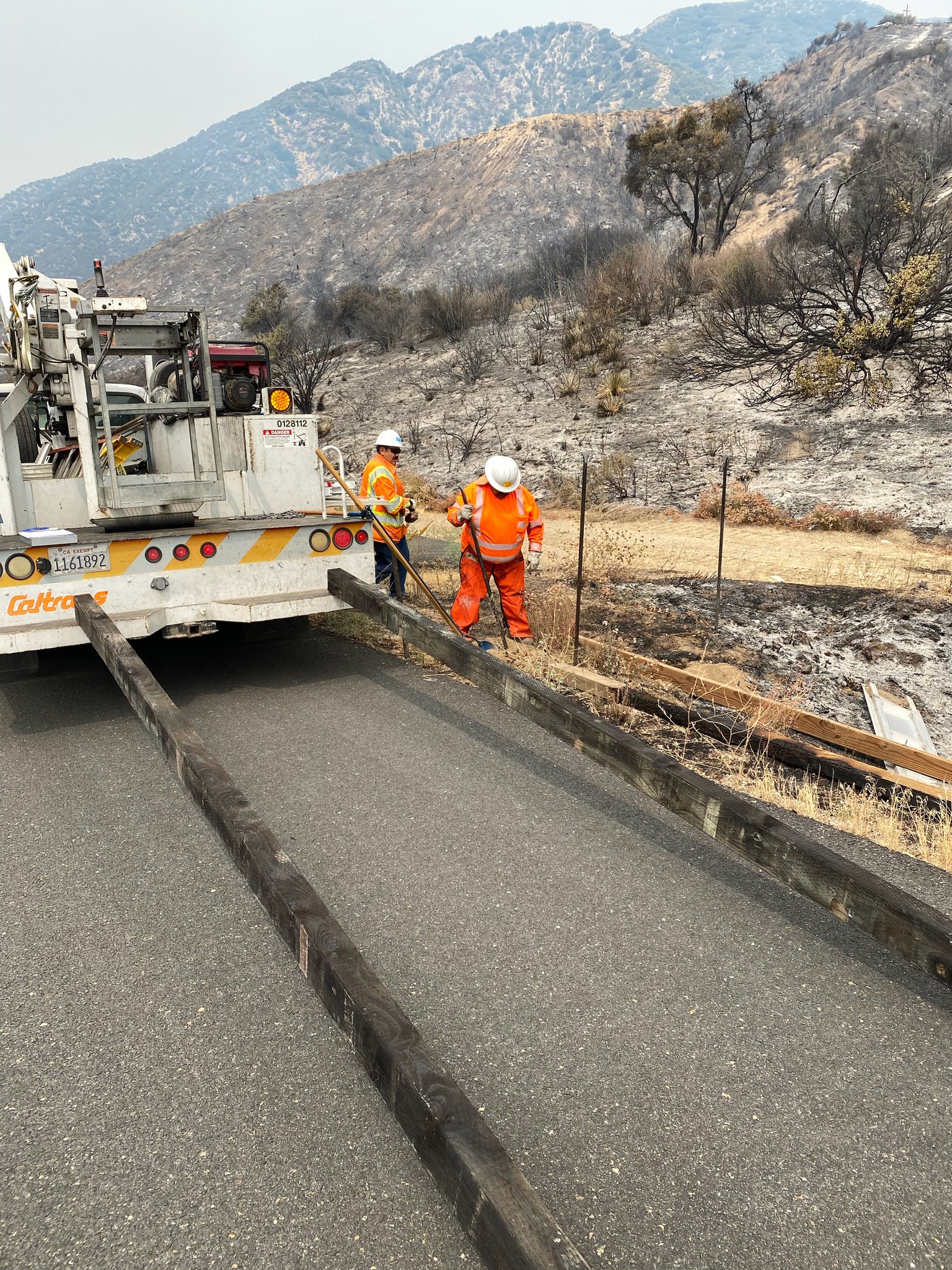

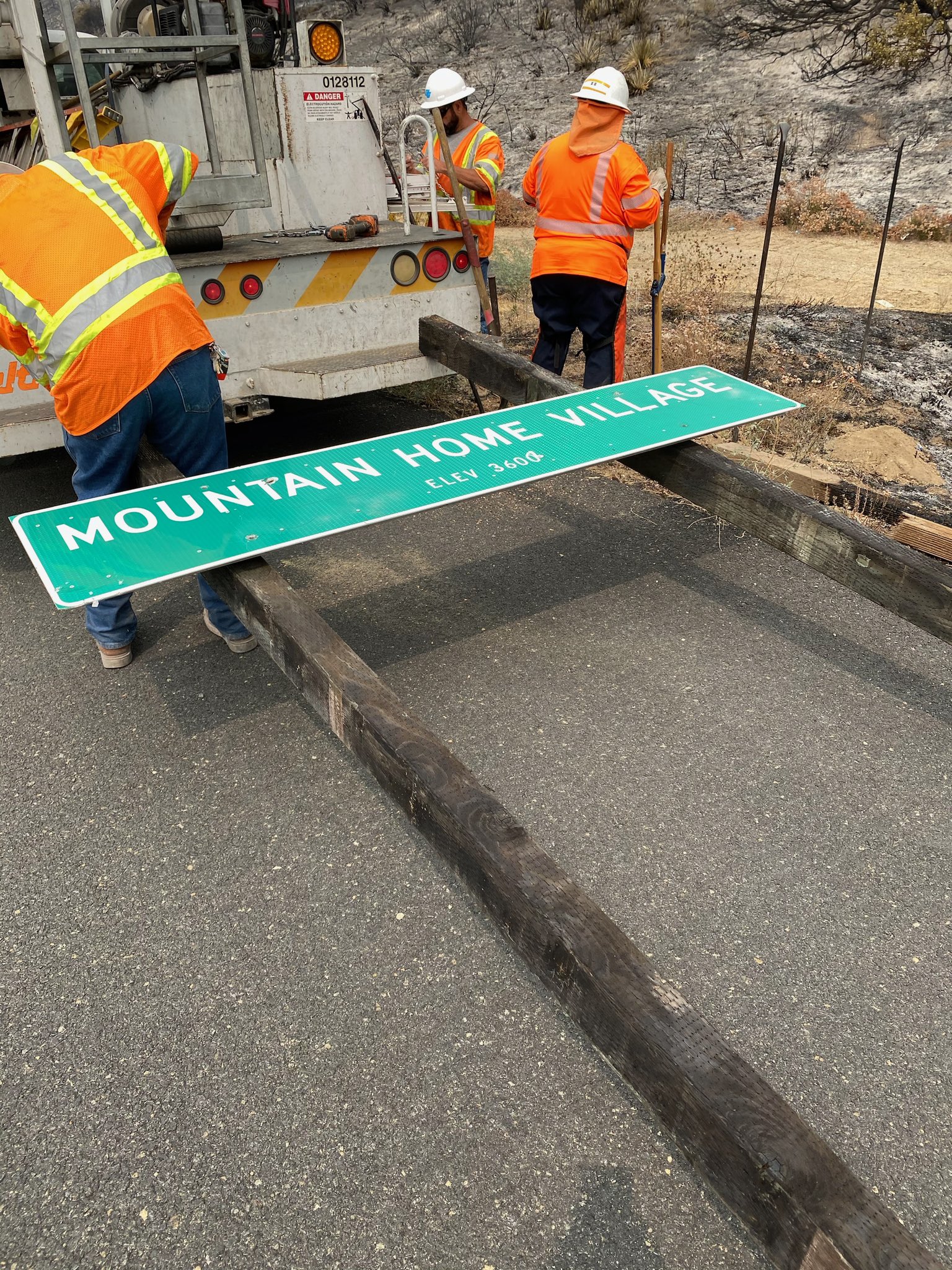
Re: EL DORADO FIRE Updates
Mtngoat John⭐, Mon Sep 14 2020, 07:17AM
Briefing map for 9-14-20
Click image to enlarge
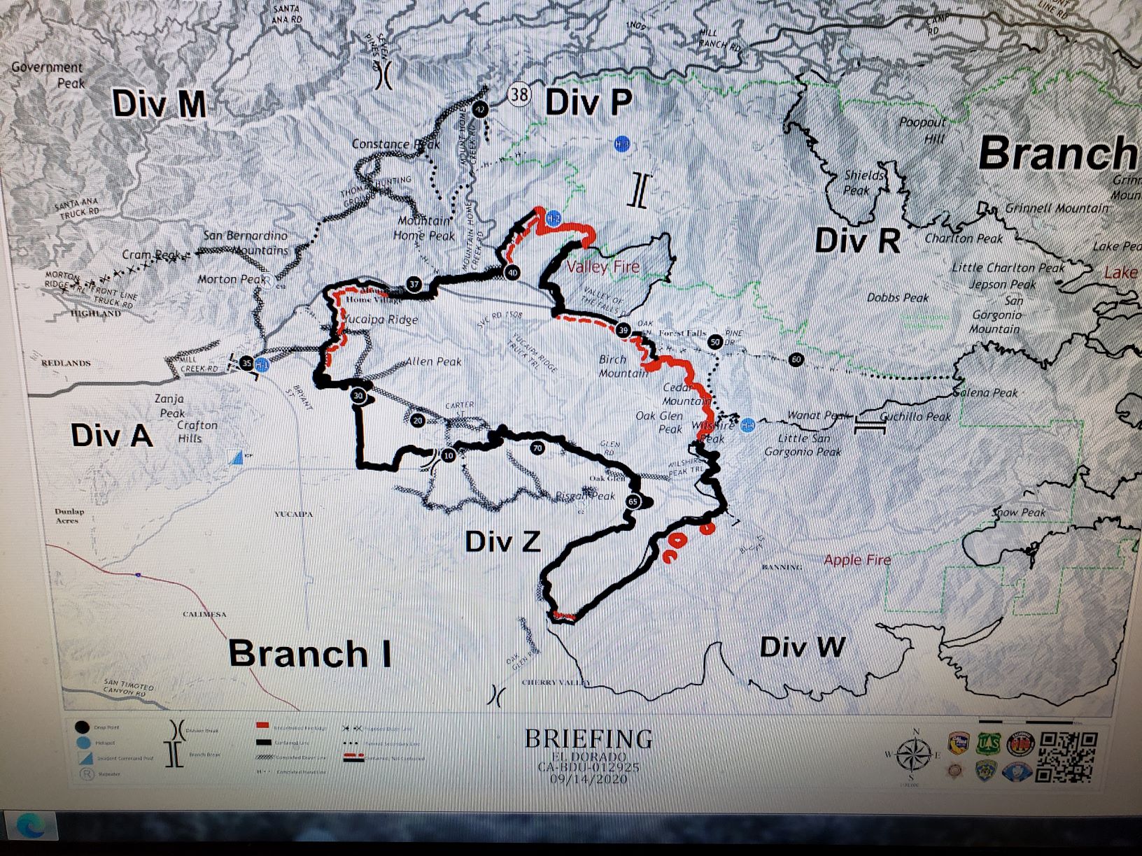
Re: EL DORADO FIRE Updates
Mtngoat John⭐, Mon Sep 14 2020, 07:18AM
Overnight IR map
click image to enlarge

Re: EL DORADO FIRE Updates
doo·hick·ey, Mon Sep 14 2020, 08:53AM
After recently not seeing much smoke, today it is visible from Baldwin Lake.
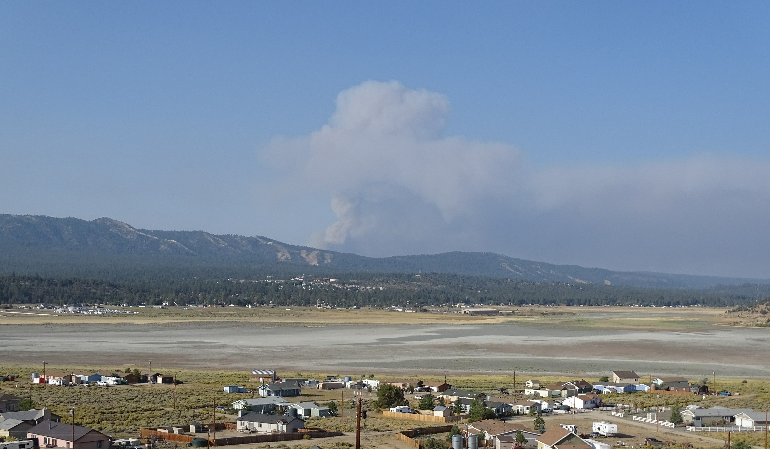
Re: EL DORADO FIRE Updates
Jellylorum, Mon Sep 14 2020, 12:29PM
This will take you to the latest video report on the USFS Facebook page. It explains concerns about the fire flare this morning.
[Click Here]
Re: EL DORADO FIRE Updates
STAXX, Mon Sep 14 2020, 12:51PM
Satellite fire info...
[Click Here]
I needed some perspective... organized some info views:
[Click Here]
![[Click Here]](http://www.mh11.com/wp-content/uploads/2020/09/OrganizedViewInfo.jpg)
Re: EL DORADO FIRE Updates
HBadger, Mon Sep 14 2020, 01:17PM
trim.1fafe6ec-a6d2-4ce4-8e7e-4030bd1aebc3.movRe: EL DORADO FIRE Updates
Mtngoat John⭐, Mon Sep 14 2020, 03:18PM
Courtesy 564FirePhoto
Hwy38 and Jenks Lake Rd West

Re: EL DORADO FIRE Updates
Benny ⭐, Mon Sep 14 2020, 05:23PM
5:00pm Update - Monday 09/14/20
So a little better perspective. The photo below was just taken looking east towards Angelus Oaks. Angelus Oaks is on the bottom left below the retardant line. Winds have decreased so we're back to terrain driven, fire now running uphill towards San Bernardino Peak. They're going to try to run it east into the old Lake Fire scar. Might also do some backfiring operations tonight (wind permitting) behind/south of Jenks Lake and try to run it out of fuel on the north side. Fire is currently 1 mile south of highway 38, but just creeping downhill with slow rollout. Dozers are all over the place cutting/widening lines, around Angelus Oaks, down in Seven Oaks, and planning to work up along Skyline to have multiple contingencies to stop the fire, should it keep progressing north.
A 2,000 acre increase today.
6:30pm Update per USFS
Acres: 16,490
Containment: 53%
Personnel: 1,319
Injuries: 10
Evacuated: 3,467
Structures threatened: 16,117
More: [Click Here]
CLICK TO ENLARGE
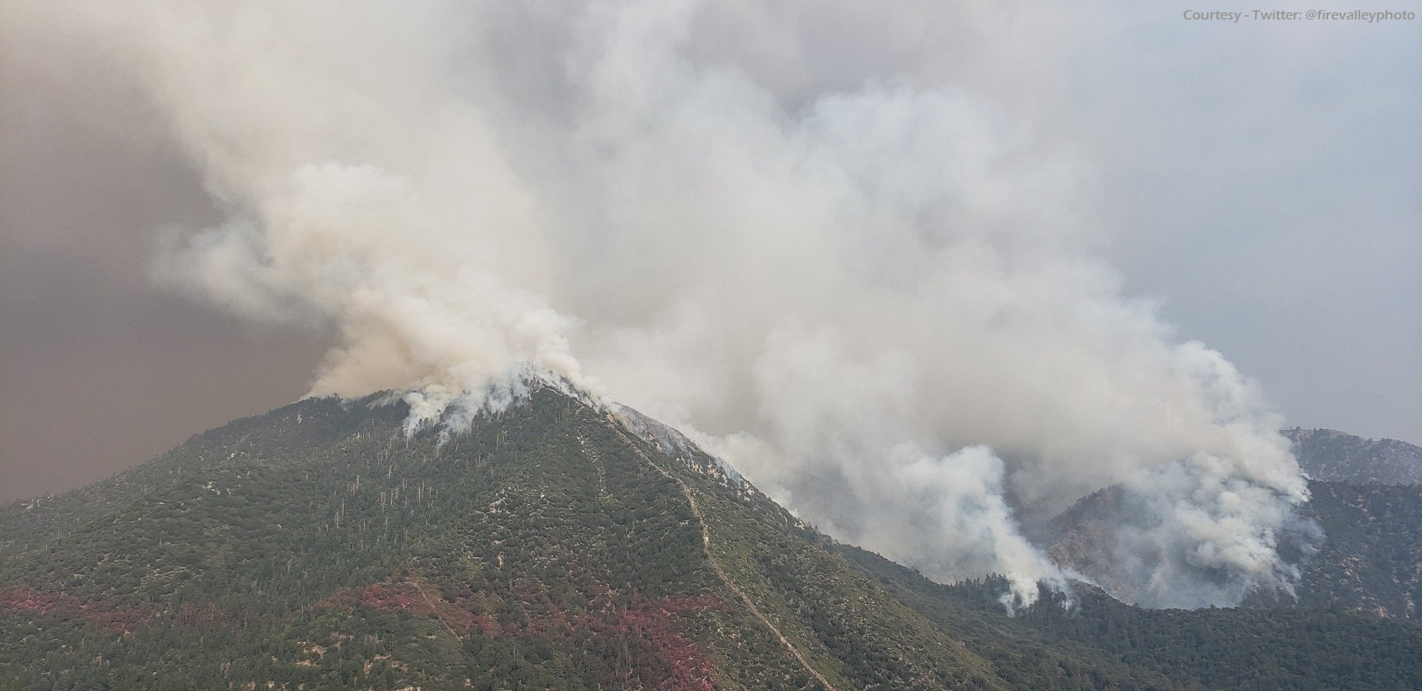
Re: EL DORADO FIRE Updates
BBNona, Mon Sep 14 2020, 06:21PM
That’s awesome Benny. Those are some scary pics. Hope and pray everyone is out safe.
Re: EL DORADO FIRE Updates
Benny ⭐, Mon Sep 14 2020, 07:36PM
El Dorado Fire: September 14, 2020 PM Update
Public Information: San Bernardino National Forest: Twitter: @SanBernardinoNF
Phone: (909) 383-5688 [Click Here] Facebook: SanBernardinoNF
[Click Here]
INCIDENT INFORMATION
UNIFIED COMMAND: CAL FIRE BDU/Yucaipa, San Bernardino National Forest, San Bernardino County Fire, San Bernardino County Sheriff, California Highway Patrol
Start Date: 9/05/2020
Location: Oak Glen/West Yucaipa in
San Bernardino County CA
Size: 16,490 acres
Percent containment: 53%
Cause: Human-caused
ASSIGNED RESOURCES:
Hand Crews: 19
Helicopters: 11
Engines: 205
Dozers: 17
Water Tenders: 20
Total Personnel: 1,319
Injuries: 10
Structures Threatened: 16,117 Residence: Damaged 2 Destroyed: 4
Other Str: Damaged 4 Destroyed: 6
CURRENT CONDITIONS:
The El Dorado Fire burned actively throughout the day as the topography aligned with upslope wind influence allowing for active head fire runs. Firefighters have built a contingency line between the fire and the Angelus Oaks community to plan for this possibility. Currently, the fire is near Angelus Oaks but burning actively upslope towards San Bernardino Peak (northwest) towards the Lake Fire scar.
Fire activity will remain active overnight due to dry and hot weather with limited relative humidity recovery and a down canyon wind influence. Firefighters are poised and ready to conduct firing operations around Angeles Oaks if needed. The fire may back downslope gently towards the community. Fire crews are in position to directly attack the fire with both hand lines and hose lines.
There is NO evacuation directive for Big Bear residents at this time!!!
Along Hwy 38, the fire activity continues to slowly back down the slope and burn eastward along Mill Creek. The fire line behind Forest Falls continues to hold and firefighters continue to work in and around this community. Fire crews continue working to secure the fire line along Mill Creek from Vivian Creek to last month’s Apple Fire scar.
Residents of Mountain Home, we continue to ask for your patience. Our work in and around your community is not complete yet. Power lines are still down and we ask that you stay away from your homes for a little longer.
WEATHER:
The weather will remain hot and dry with upslope winds during the afternoons and downslope winds in the evening. Predictive Services division of the Southern California Geographic Area Coordination Center has issued a fuels advisory for excessively dry fuels throughout California due to drought conditions and hot temperatures.
Please check Inciweb, Twitter and Facebook for changes and updates on the #ElDoradoFire.
ROAD CLOSURES:
• Highway 38 is closed between Bryant St. to the south and Onyx Summit to the north
EVACUATIONS:
Evacuation Orders:
Evacuation Orders Remain In Effect for Mountain Home Village, Forest Falls, Angelus Oaks and Seven Oaks. All residents who have not yet evacuated in the Angelus Oaks area please leave!!!
Please see map link: [Click Here]
The physical temporary evacuation point at Redland’s East Valley High School will close tonight at 7:00 pm. Those seeking assistance tonight can call the virtual assistance line at (760)646-3824. Red Cross disaster workers will re-open the physical location for the Temporary Evacuation Point at Redland East Valley High School on Tuesday, September 15 at 7:00 am.
TRAVEL NOTES:
The El Dorado Fire Unified Incident Commanders continue to ask visitors to consider rescheduling planned visits to the Big Bear area due to fire activity. Please check the Big Bear Fire Department Travel Advisory for the reasons why: [Click Here]
SAN BERNARDINO NATIONAL FOREST RECREATION CLOSURES:
The entire Forest was closed to all public use at 5 p.m. on Monday, Sept. 7. Please see [Click Here] for more information.
Re: EL DORADO FIRE Updates
Kats, Mon Sep 14 2020, 07:37PM
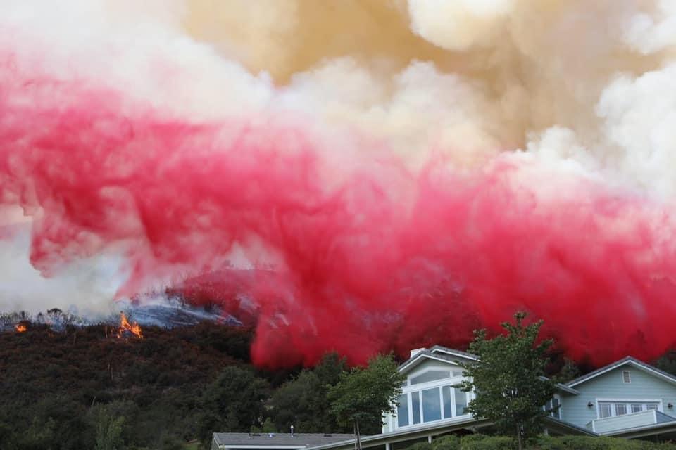
Re: EL DORADO FIRE Updates
Benny ⭐, Mon Sep 14 2020, 08:15PM
Great photos!
Here's an evening update from Fire Chief Willis....
[Click Here]
Re: EL DORADO FIRE Updates
Mtngoat John⭐, Tue Sep 15 2020, 05:31AM
9-15-20 Briefing map
click image to enlarge
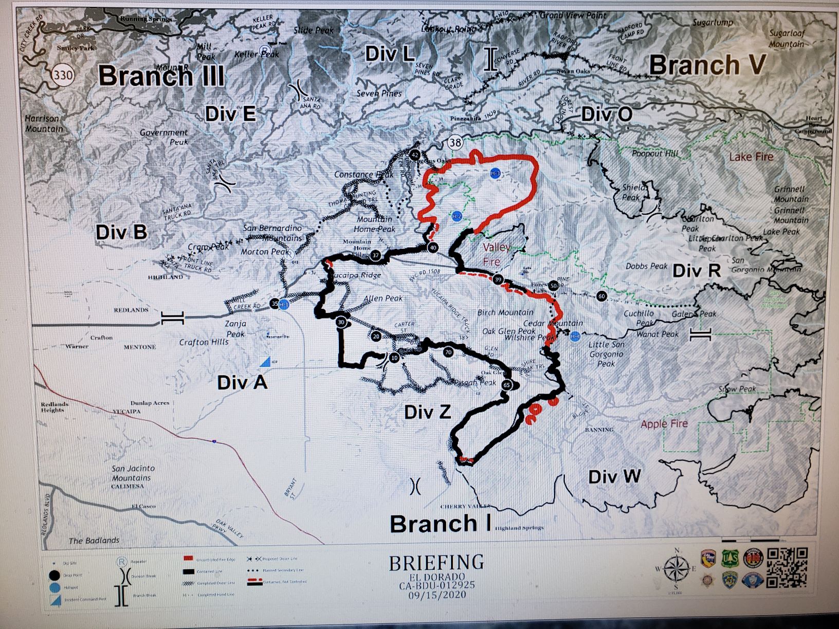
Re: EL DORADO FIRE Updates
Mtngoat John⭐, Tue Sep 15 2020, 05:32AM
9-15-20 Pilot Map
click image to enlarge

Re: EL DORADO FIRE Updates
McToddy, Tue Sep 15 2020, 10:28AM
Hey all --
I've put all my pics of the fire into one single album in Google Photos. I'll be adding more photos to this link over time
[Click Here]
Re: EL DORADO FIRE Updates
BootsNBridles, Tue Sep 15 2020, 11:38AM
Here's the link to the Flight Rader that shows all planes in the area: [Click Here]
Re: EL DORADO FIRE Updates
Squatch, Tue Sep 15 2020, 12:45PM
BootsNBridles wrote ...
Here's the link to the Flight Rader that shows all planes in the area: [Click Here]
Here's the link to the Flight Rader that shows all planes in the area: [Click Here]
Awesome link!
Re: EL DORADO FIRE Updates
Mtngoat John⭐, Thu Sep 17 2020, 06:46AM
9-17-20 Briefing Map
Click image to enlarge
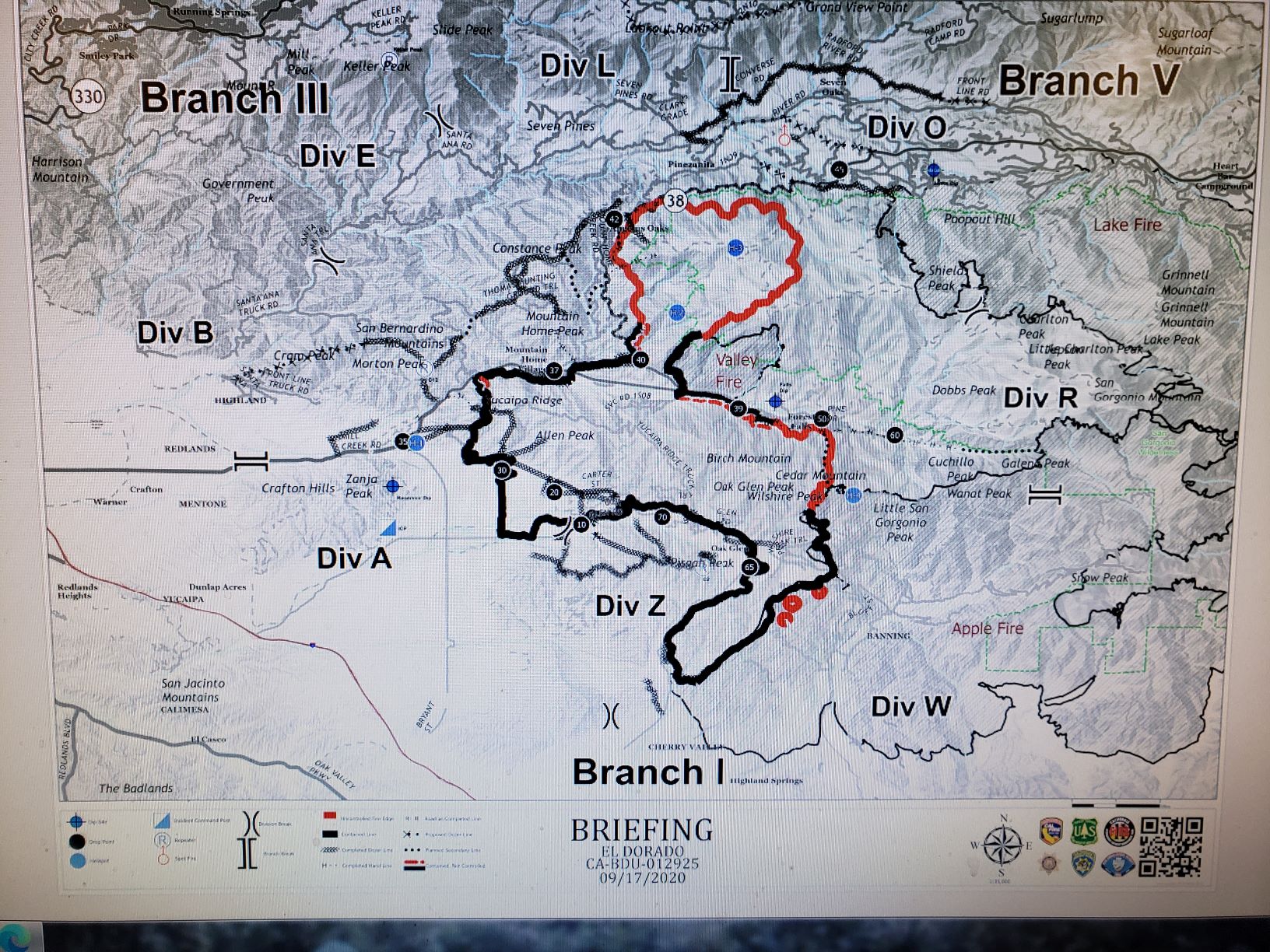
Re: EL DORADO FIRE Updates
Mtngoat John⭐, Thu Sep 17 2020, 06:47AM
This mornings Pilot Map
click to enlarge image

Re: EL DORADO FIRE Updates
Hooky Bobber, Fri Sep 18 2020, 07:11AM
deck 9/18 morning summit area

Re: EL DORADO FIRE Updates
Hooky Bobber, Fri Sep 18 2020, 07:12AM
Updates: Read the September 18, 2020 Morning Update.
Daily Videos - Operational Update from the El Dorado Fire (9/17).
View detailed Fire Perimeter Maps (9/18) for the Angelus Oaks Area, 7 Oaks / Pinezanita, Jenks Lake Area, and the San Bernardino Peak Area.
2020_09_16-16.30.04.561-CDT.jpeg
CURRENT CONDITIONS:
The El Dorado fire burned actively overnight along Hwy 38 into Angelus Oaks. Fire was spotting into the community and was quickly extinguished by fire crews providing structure defense. The fire continued to burn with high intensity along Hwy 38 near the Pinezanita area. Ember cast across Hwy 38 was quickly extinguished by ground crews directly attacking the fire with hose lines. Structure defense continues from Pinezanita to Jenks Lake by increasing defensible space, hose line placement and securing fire line. The fire has progressed to the Lake Fire scar and continues to make active runs to the north as topography and up-canyon wind influences comes into alignment. Fire is spotting ½ mile ahead of the main body of fire and has a potential for spotting up to 1 mile this afternoon.
There are no active spot fires that have crossed Hwy 38. We understand that many residents may be looking at Modis online. Modis is an instrument aboard the Terra and Aqua EOS Satellites and measure thermal and infrared detections. This can create confusion as anything emitting heat registers in Modis, including smoke AND fire-fighting equipment. What communities are perceiving as spot fires across Hwy 38 is likely smoke or equipment operating in the area. As of this update, the El Dorado Fire has NOT crossed Highway 38. Please know that the firefighters working in this area are monitoring this possibility very carefully.
Caifornia Interagency Incident Management Team 11(Fogle) transitioned with California Interagency Incident Management Team 13(Wakoski) today at 0700 am. The Unified Command remains in place with Cal Fire BDU/Yucaipa, San Bernardino National Forest, San Bernardino County Fire, San Bernardino County Sheriffs, and California Highway Patrol.
There is NO evacuation directive for Big Bear residents AT THIS TIME. Please monitor official sources for any changes including the San Bernardino National Forest information listed at the top of this update, San Bernardino Sheriff’s Department, the CAL Fire San Bernardino Unit and San Bernardino County Fire.
All residents waiting to return home: we ask for your continued patience. We are re-evaluating repopulation daily with the utility companies, CalTrans, CHP and San Bernardino County Sheriff’s Department as they repair critical infrastructure. We ask that you continue to support the firefighters by staying out of the way until we can open your neighborhood safely for you.
Angelus Oaks and Forest Falls Post Offices are closed temporarily, however residents of these communities can pick up their mail at the Yucaipa Post Office, located at 12460 California St, Yucaipa, CA 92305 until further notice. Please bring a valid photo ID when picking up mail. The Yucaipa Post Office is open Monday – Friday 9:00 to 5:00, Saturday 11:00 – 4:00.
The El Dorado Fire has been burning for 14 days, and is currently estimated at 21,678 acres with 66% containment.
Residences: 4 destroyed, and 2 damaged; Minor structures/outbuildings: 6 destroyed, and 4 damaged.
Weather:
A high-pressure weather system remains over the fire resulting in winds from the southwest above 6,000 feet elevation. The predominant diurnal winds continue below 6000 feet elevation and will transition to down canyon overnight.
Smoke Impacts:
Please read the Daily Smoke Report issued by the Wildland Fire Air Quality Program. Smoke will continue to impact portions of the Inland Empire and the San Gorgonio Pass area today and tonight, although much of the smoke in the upper atmosphere is from fires in central California. The Southern California AQMD has issued a Smoke Advisory due to smoke from the El Dorado Fire and the Bobcat Fire. Visit [Click Here] for air quality updates in your area.
Evacuations Orders:
The area east of Bryant Street on Highway 38 REMAINS UNDER AN EVACUATION ORDER. This including Mountain Home, Forest Falls, Angelus Oak, 7 Oaks and Barton Flats / Jenks Lake Area east to Onyx Summit.
Residents and businesses may check to see if they are within evacuation order or warning areas by going to the San Bernardino County Sheriffs Interactive Mapping Tool.
Big Bear residents, please monitor the El Dorado Fire and stay informed on fire conditions. Please check social media platforms frequently for updates on the #ElDoradoFire.
Fire Managers and Big Bear Emergency Agencies issued a Travel Advisory Notice for visitors to the Big Bear Area, who are urged to consider postponing their travel due to the El Dorado Fire.
A Red Cross is located at the Redlands East Valley High School, 31000 E. Colton Ave. Redlands.
Emergency Notification Systems:
San Bernardino County Assistant Fire Chief Kat Opliger talks about the importance of the Telephone Emergency Notification System (TENS) in helping San Bernardino County manage evacuation notifications during fires and other emergencies.
San Bernardino County Residents: Sign up for San Bernardino County Telephone Emergency Notification System, or call 1-888-435-7565.
Riverside County Residents: Sign up for the Riverside County Swift911 System. Visit [Click Here] for updated information and preparedness information.
Road Closures:
Highway 38 is closed between Bryant St. and Lake Williams Dr.
Recent Facebook Live Meeting:
A Facebook Live event was held on Sept 15th through the San Bernardino County Fire Facebook Page. Representatives from the San Bernardino County Board of Supervisors, San Bernardino County Fire, San Bernardino County Sheriffs Department, Cal Fire BDU, and California Incident Management Team 11 discussed the current activity on the El Dorado Fire, what things might happen with future evacuations, and answered questions that were posted online. Please take the time to watch this informative video by connecting to the San Bernardino County Fire Facebook. Meeting starts at 6:00, (Skip ahead).
Forest Closure Order of 8 National Forests:
The Regional Forester has closed All National Forests in California, including the San Bernardino National Forest. This is due to the threat from Extreme Fire Danger, rapid fire growth in new fires starts, and firefighting resources being spread stretched to the limit. This includes driving Forest Roads, Hiking on Forest Trails, and being in any Forest Service Developed Recreation Areas. Please take the time to read and understand the Regional Forester's Decision Letter. The Regional Forest Emergency Closure Order and Regional Forest Fire Restriction Order were extended to September 21st. These orders will be reviewed daily, and may be rescinded early if the underlying conditions which prompted the orders change.
Unified Command Partners:
- CAL FIRE BDU
- San Bernardino County Fire
- San Bernardino County Sheriff's Department
- California Highway Patrol
- City of Yucaipa
- San Bernardino National Forest
Aviation and Drone Safety:
The FAA has issued a Safety No Fly Zone for civilian aircraft around the El Dorado Fire. Restricted Air Space is 5 Nautical Mile Radius from the Fire, and below 10,000 feet. This includes all types of personal hobby drones. Remember, If you Fly, We Cant! For specifics, please visit the FAA NOTAM Webpage.
Re: EL DORADO FIRE Updates
Spiceguy , Fri Sep 18 2020, 07:41AM
Skyline Drive wrote ...
deck 9/18 morning summit area
deck 9/18 morning summit area
Exactly what our decks looked like this morning as well.
Re: EL DORADO FIRE Updates
Hooky Bobber, Fri Sep 18 2020, 08:02AM
NWS forecast for AO EW9887 Angelus Oaks (E9887)
[Click Here]
Today
Widespread haze. Areas of smoke. Sunny, with a high near 74. Southwest wind 10 to 20 mph, with gusts as high as 30 mph.
Tonight
Widespread haze. Areas of smoke before 11pm. Mostly clear, with a low around 53. South wind 10 to 15 mph, with gusts as high as 20 mph.
Saturday
Widespread haze. Sunny, with a high near 72. Southwest wind 5 to 15 mph, with gusts as high as 25 mph.
Saturday Night
Clear, with a low around 52. South wind around 10 mph, with gusts as high as 20 mph.
Sunday
Sunny, with a high near 72. Southwest wind 5 to 10 mph, with gusts as high as 20 mph.
Re: EL DORADO FIRE Updates
Hooky Bobber, Sat Sep 19 2020, 04:49AM
Operations Chief Diaz Daily Video Update Sept 17
[Click Here]
Re: EL DORADO FIRE Updates
Hooky Bobber, Sat Sep 19 2020, 04:51AM
9/19 eldorado map
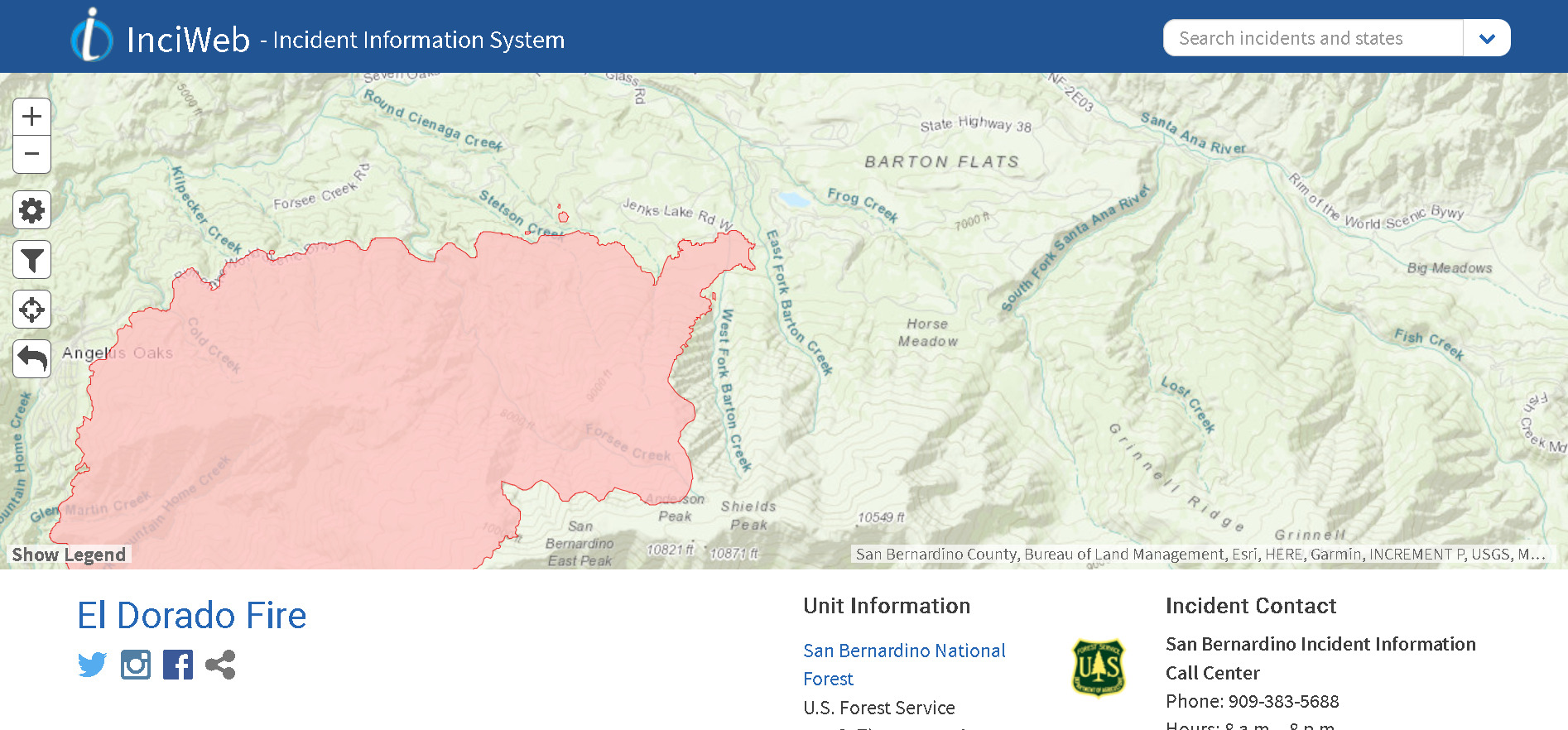
Re: EL DORADO FIRE Updates
Hooky Bobber, Sat Sep 19 2020, 04:58AM
Updates: September 18, 2020 Evening Update.
Daily Videos - Operational Update from the El Dorado Fire (9/17).
Detailed Fire Perimeter Maps (9/18) for the Angelus Oaks Area,7 Oaks / Pinezanita, Jenks Lake Area, and the San Bernardino Peak Area.
Current Condition:
The El Dorado Fire continued to burn actively along Hwy 38 and in and around Angelus Oaks. The fire spotted into the community but was quickly extinguished by crews in place to provide structure defense. The presence of these fire crews along with air support kept the fire on the South and East side of Highway 38.
The fire continues to impact the communities of Angelus Oaks, Mountain Home Village, Forest Falls, and threatens the areas of Glen Martin School, San Bernardino Peak, Anderson Peak, Pinezanita, Horse Flats, Barton Flats, Anderson Peak, and Heart Bar.
Fire growth continues to the northeast and has slowed as it moves into the old Valley and Lake Fire burn scars.
A well-attended community meeting was held in Forest Falls. Residents practiced coronavirus protocols with masks and social distancing.
Weather:
Dry, warm, and breezy conditions will continue over the fire on Saturday and Saturday evening. Winds will be west and Southwest 10 MPH Sustained with gust to 20 MPH. Temperatures will be around 85 degrees
There is NO evacuation directive for Big Bear residents AT THIS TIME. Please monitor official sources for any changes including the San Bernardino National Forest information listed at the top of this update, San Bernardino Sheriff’s Department, the CAL Fire San Bernardino Unit and San Bernardino County Fire.
All residents waiting to return home: we ask for your continued patience. We are re-evaluating repopulation daily with CHP, and San Bernardino County Sheriff’s Department. The utility companies, and CalTrans continue repairing critical infrastructure. Please be cautious and aware of crews working in the area.
Angelus Oaks and Forest Falls Post Offices are closed temporarily, however residents of these communities can pick up their mail at the Yucaipa Post Office, located at 12460 California St, Yucaipa, CA 92305 until further notice. Please bring a valid photo ID when picking up mail. The Yucaipa Post Office is open Monday – Friday 9:00 to 5:00, Saturday 11:00 – 4:00.
The El Dorado Fire has been burning for 14 days, and is currently estimated at 22,071 acres with 65% containment.
Residences: 4 destroyed and 2 damaged; Minor structures/outbuildings: 6 destroyed, and 4 damaged.
Smoke Impacts:
Please read the Daily Smoke Report issued by the Wildland Fire Air Quality Program. Smoke will continue to impact portions of the Inland Empire and the San Gorgonio Pass area today and tonight, although much of the smoke in the upper atmosphere is from fires in central California. The Southern California AQMD has issued a Smoke Advisory due to smoke from the El Dorado Fire and the Bobcat Fire. Visit [Click Here] for air quality updates in your area.
Evacuations Orders:
Community of Angelus Oak, 7 Oaks and Barton Flats / Jenks Lake Area east to Onyx Summit.
Evacuation Warnings:
Mountain Home Village and Forest Falls are now open to Residents Only. Please have ID.
Residents and businesses may check to see if they are within evacuation order or warning areas by going to the San Bernardino County Sheriffs Interactive Mapping Tool.
Big Bear residents, please monitor the El Dorado Fire and stay informed on fire conditions. Please check social media platforms frequently for updates on the #ElDoradoFire.
Fire Managers and Big Bear Emergency Agencies issued a Travel Advisory Notice for visitors to the Big Bear Area, who are urged to consider postponing their travel due to the El Dorado Fire.
A Red Cross is located at the Redlands East Valley High School, 31000 E. Colton Ave. Redlands.
Emergency Notification Systems:
San Bernardino County Assistant Fire Chief Kat Opliger talks about the importance of the Telephone Emergency Notification System (TENS) in helping San Bernardino County manage evacuation notifications during fires and other emergencies.
San Bernardino County Residents: Sign up for San Bernardino County Telephone Emergency Notification System, or call 1-888-435-7565.
Riverside County Residents: Sign up for the Riverside County Swift911 System. Visit [Click Here] for updated information and preparedness information.
Road Closures:
Highway 38 is closed between Bryant St. and Lake Williams Dr. Residents of Mountain Home Village and Forest Falls will be allowed through the Bryant Street Checkpoint. A Hard Closure is in place above Valley of the Falls Drive on Highway 38.
Re: EL DORADO FIRE Updates
Hooky Bobber, Sat Sep 19 2020, 04:59AM
Video link eldorado
[Click Here]
Re: EL DORADO FIRE Updates
Mtngoat John⭐, Sat Sep 19 2020, 05:45AM
This mornings Briefing Map
9-19-20
click image to enlarge
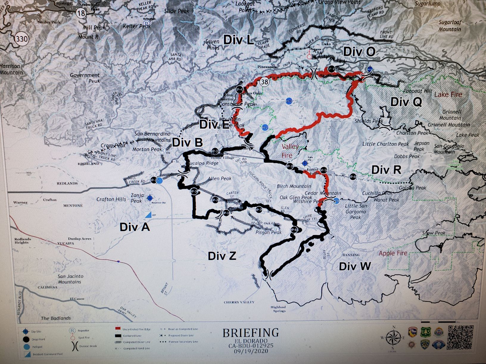
Re: EL DORADO FIRE Updates
Mtngoat John⭐, Sat Sep 19 2020, 05:46AM
9-19-20 Pilot map
click image to enlarge

Re: EL DORADO FIRE Updates
Hooky Bobber, Sun Sep 20 2020, 09:29AM
Updates: September 20, 2020 Morning Update
Detailed Fire Perimeter Maps (9/19) for the Angelus Oaks Area,7 Oaks / Pinezanita,Jenks Lake Area.
Daily Smoke Outlook - Los Angeles and Inland Empire Areas - September 19
Current Condition:
The El Dorado’s Fire behavior overnight has decreased compared to the previous daytime period. Fire behavior decreased to the east as it burns into the old Lake Fire burn scar. With the forecasted weather, firefighters continue to make progress building containment line and putting in hose lays around in key areas on the fire. The fire continues to backdown to Hwy 38 with some upslope runs. Spot fires remain a concern along the 38 corridor. The Oak Glen, Yucaipa, Banning, and Beaumont side of the fire have moved into patrol status.
The El Dorado Fire started on September 5, 2020, in El Dorado Park located in the Yucaipa/Oak Glen area of Southern California, which is managed by the California Department of Forestry and Fire Protection, CAL FIRE. Prior to the fire, Southern California was experiencing a series of heat waves. On the day of the fire, we had record breaking temperatures across the region. Due to the dry conditions and grass covered hills, the fire spread rapidly onto Forest Lands in the San Bernardino National Forest. With a record number of fires throughout California, fire resources are spread thin.
With high temperatures and dry vegetation, the public is encouraged to be more vigilant and cautious when recreating near public lands and open spaces. Residents should evaluate their properties for defensible space and ensure they have adequate hazard reduction.
Weather:
A trough of low pressure continued through the area today. This will continue southwest winds during the day and evening hours for most locations. Sheltered valleys will likely see down canyon winds at night and relative humidity will slowly increase this weekend. Temperatures 90-94 degrees at 3000’ and 77-80 degrees at 6000’
Re: EL DORADO FIRE Updates
Hooky Bobber, Sun Sep 20 2020, 09:32AM
Detailed Area Maps A O September 19
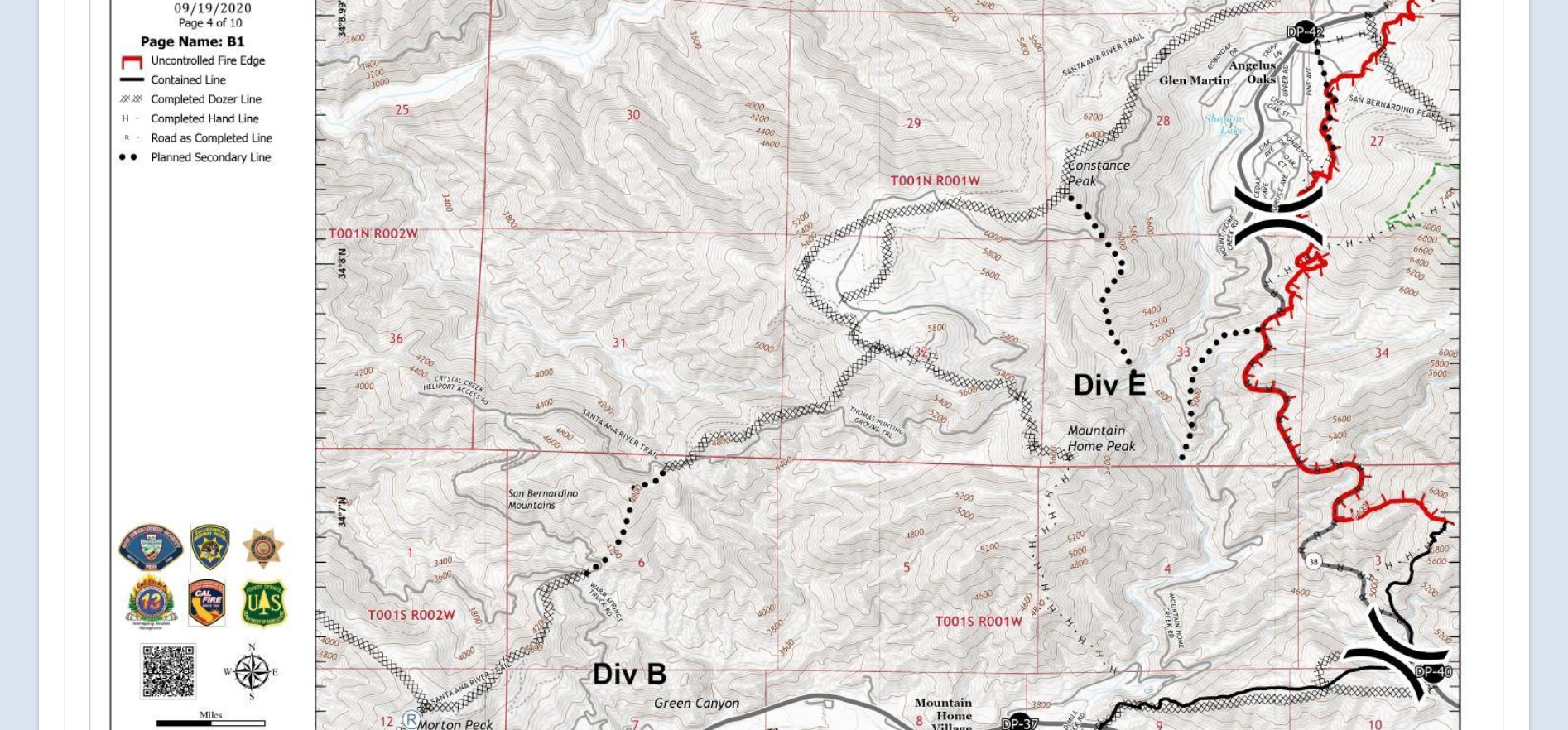
Re: EL DORADO FIRE Updates
Hooky Bobber, Sun Sep 20 2020, 09:35AM
Pinezanita Area OPS Map
Hope to pick apples in a couple weeks
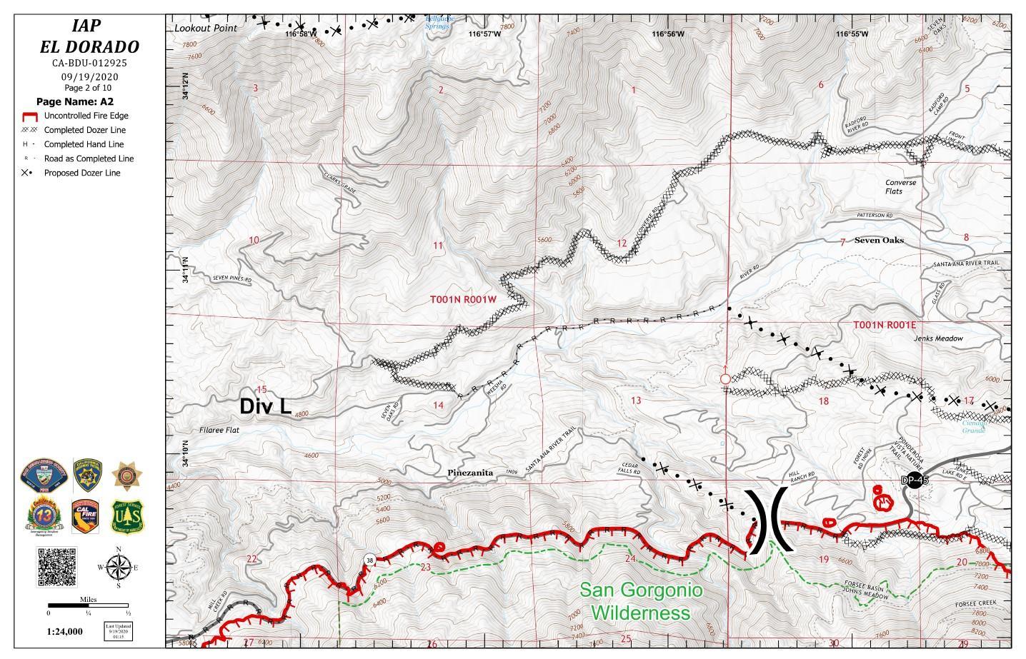
Re: EL DORADO FIRE Updates
Hooky Bobber, Sun Sep 20 2020, 09:37AM
Jenks Lake ARea OPS Map
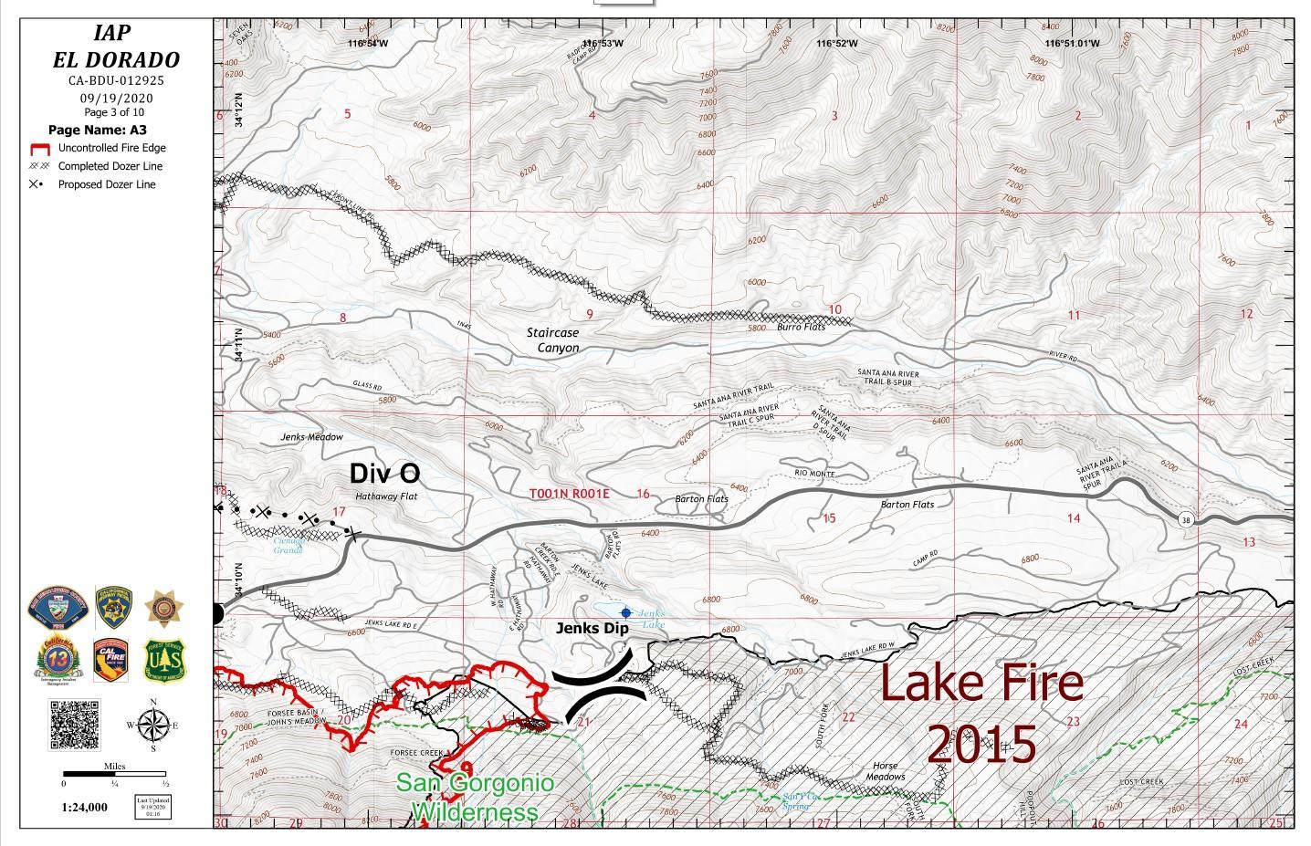
Re: EL DORADO FIRE Updates
Hooky Bobber, Sun Sep 20 2020, 09:40AM
Angelus Oaks Area OPS Map

Re: EL DORADO FIRE Updates
Hooky Bobber, Sun Sep 20 2020, 09:52AM
El Dorado Fire Perimeter, September 20, 2020
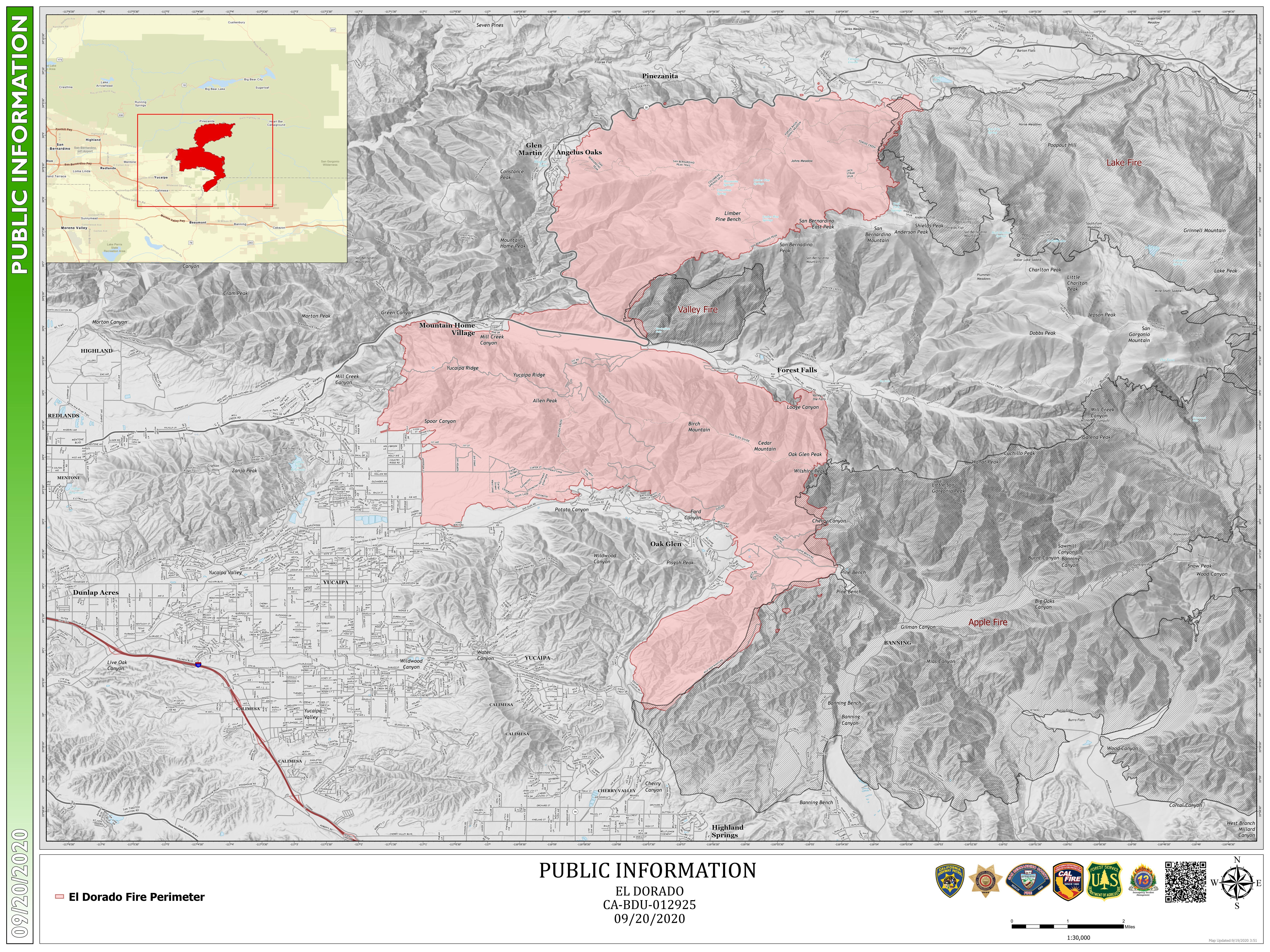
Re: EL DORADO FIRE Updates
Hooky Bobber, Sun Sep 20 2020, 12:30PM
Angles Oaks

Re: EL DORADO FIRE Updates
Hooky Bobber, Sun Sep 20 2020, 12:48PM
Re: EL DORADO FIRE Updates
Hooky Bobber, Tue Sep 22 2020, 06:57AM
SAN BERNARDINO, Calif., September 21, 2020 – It is with deep sadness that USDA Forest Service officials on the San Bernardino National Forest announce the death of Charles Morton, a Big Bear Interagency Hotshot Squad Boss, who died while engaged in fire suppression operations on the El Dorado Fire late Thursday, September 17, 2020.
Full Press Release, Photo
[Click Here]
Procession of vehiclestoescortfallen firefighter Charles Morton to Orange Countymortuary SAN BERNARDINO, Calif.–AU.S. Forest Servicehonor guard, along with the California Highway Patrol, will escort fallen Big Bear Interagency Hotshot Charles Mortonin a solemn processionto a mortuary in Orange Countyonthe morning ofTuesday, September22, 2020.The procession will begin at 10:30 a.m. from the main office of theSan Bernardino County Coroner’sDivisionin San Bernardino, Calif., and end at Ferrara & Lee Colonial Mortuaryin Orange, Calif.The route will be as follows: •Start at theSan Bernardino County Coroner’s Division main office at175 S. Lena Rd.,San Bernardino, Calif. 92415•South on Lena Rd. to Mill St.•Weston MillSt.to Waterman Ave.•South on Waterman to I-215 South Riverside Freeway•South toSR-91to Imperial Highway•South onImperial Highway to Santiago Canyon Rd.•West on Santiago Canyon Rd to Hewes St.•South onHewes St.•Arrive at Ferrara Colonia Mortuary, 351 N. Hewes St, Orange, Calif. 92869
Re: EL DORADO FIRE Updates
McToddy, Tue Sep 22 2020, 11:40AM
Here's the link to video clips of air ops on Sun & Mon
[Click Here]
Sorry it's so rough - it was a quick turn and burn (opps, no pun intended) to get the video posted for a quick turnaround
Re: EL DORADO FIRE Updates
BBNona, Tue Sep 22 2020, 07:55PM
Awesome McToddy! Thank u! Love these clips!
Re: EL DORADO FIRE Updates
SCM ALERT🚨, Tue Sep 22 2020, 09:23PM
AWESOME Stuff McToddy!! Thank you!
Re: EL DORADO FIRE Updates
Gruuv, Tue Sep 22 2020, 11:03PM
Thanks for taking the time to post those, McToddy. Super cool to see!
Re: EL DORADO FIRE Updates
Hooky Bobber, Wed Sep 23 2020, 06:42AM
District Attorney Jason Anderson Issues Statement Regarding The El Dorado Fire
[Click Here]
Re: EL DORADO FIRE Updates
Hooky Bobber, Wed Sep 23 2020, 06:46AM
Procession honors fallen California firefighter
[Click Here]
Re: EL DORADO FIRE Updates
SCM ALERT🚨, Thu Sep 24 2020, 09:59PM
EVACUATION ORDERS NOW LIFTED TO A WARNING... WHILE CONDITIONS ARE IMPROVING ON THE EL DORADO FIRE, ALWAYS BE PREPARED SHOULD CONDITIONS CHANGE AND ANOTHER EVACUATION IS ORDERED! HIGHWAY 38 IS NOW OPEN TO RESIDENTS ONLY OF M.H.V., F.F., A.O., 7-OAKS, B.F. & O.S, YOU MAY RETURN HOME FROM EITHER SIDE OF 38, DRIVE SLOW AND BE CAUTIOUS OF FIREFIGHTERS STILL WORKING THE AREA. NO THROUGH TRAFFIC TO BIG BEAR! ID IS REQUIRED FOR RESIDENTS OF THOSE COMMUNITIES ONLY!
Re: EL DORADO FIRE Updates
SCM ALERT🚨, Thu Sep 24 2020, 09:59PM
WELCOME HOME !
Re: EL DORADO FIRE Updates
Mtngoat John⭐, Tue Jul 20 2021, 07:41PM
Couple charged with involuntary manslaughter in Southern California fire sparked by gender reveal.
[Click Here]
Re: EL DORADO FIRE Updates
Mtngoat John⭐, Sun Jan 16 2022, 07:13AM
Final USFS report for the El Dorado Fire and Charles Morton's death
Learning Review Narrative
[Click Here]
Article from the Victorville Daily Press
[Click Here]
Re: EL DORADO FIRE Updates
SilentSky, Sun Feb 11 2024, 04:18PM
From The Sun [Click Here]:
Prosecutors reach plea deals with couple whose gender reveal party inadvertently started deadly El Dorado fire
Refugio Manuel Jimenez Jr. pleaded guilty to a felony involuntary manslaughter count for the death of firefighter Charlie Morton and two felony counts of recklessly causing a fire to an inhabited structure. He has been sentenced to two years of felony probation, one year in county jail, and 200 hours of community service.
Morton, a Forest Service firefighter on a Big Bear hotshot team, died after he became trapped against a wall of flames in the El Dorado fire.
Angelina Jimenez pleaded guilty to three misdemeanor counts of recklessly causing a fire on another person’s property. She was sentenced to a year of probation and 400 hours of community service.
The Jimenez’s also have been ordered to pay $1.7 million in restitution, according to the San Bernardino County District Attorney’s office.