From Bens Weather:
@jonathan_olson @NWSSanDiego Actually Jon, if we setup a
SCM ALERT🚨, Sun Apr 05 2020, 07:35PM
From Bens Weather:
@jonathan_olson @NWSSanDiego Actually Jon, if we setup a wrap around flow, youll see higher totals east to west. I would expect at least a fairly even spread, so plan on a foot or two out your way. Backsliders tend to dump a good amount of snow in east Valley, Baldwin Lake, Erwin Lake, Williams, e.t.c.

Re: From Bens Weather:
@jonathan_olson @NWSSanDiego Actually Jon, if we setup a
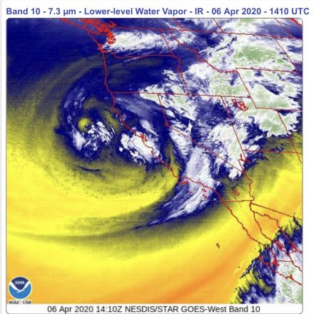
NShore.Allen, Mon Apr 06 2020, 07:33AM
Impressive iR image this morning
Re: From Bens Weather:
@jonathan_olson @NWSSanDiego Actually Jon, if we setup a
Benny ⭐, Mon Apr 06 2020, 09:26PM
Very impressive front, dumped over 5 inches of rain today in some parts and over a foot of snow in a few locations. The low offshore pretty much has us in it's crosshairs at this time. With dropping temperatures expect mostly snow from here on out, and it could be a lot. Still 1-2 feet is "expected". The heaviest snow will likely ocurr tomorrow then again Wed night-Thursday, coming in rounds.
@jonathan_olson @NWSSanDiego Actually Jon, if we setup a
SCM ALERT🚨, Sun Apr 05 2020, 07:35PM
From Bens Weather:
@jonathan_olson @NWSSanDiego Actually Jon, if we setup a wrap around flow, youll see higher totals east to west. I would expect at least a fairly even spread, so plan on a foot or two out your way. Backsliders tend to dump a good amount of snow in east Valley, Baldwin Lake, Erwin Lake, Williams, e.t.c.

Re: From Bens Weather:
@jonathan_olson @NWSSanDiego Actually Jon, if we setup a
NShore.Allen, Mon Apr 06 2020, 07:33AM
Impressive iR image this morning

Re: From Bens Weather:
@jonathan_olson @NWSSanDiego Actually Jon, if we setup a
Benny ⭐, Mon Apr 06 2020, 09:26PM
NShore.Allen wrote ...
Impressive iR image this morning
Impressive iR image this morning
Very impressive front, dumped over 5 inches of rain today in some parts and over a foot of snow in a few locations. The low offshore pretty much has us in it's crosshairs at this time. With dropping temperatures expect mostly snow from here on out, and it could be a lot. Still 1-2 feet is "expected". The heaviest snow will likely ocurr tomorrow then again Wed night-Thursday, coming in rounds.