Panorama IC
heyjude, Mon Jul 09 2012, 02:19PM
Vegetation fire onLower Waterman Canyon hwy 18. Request to shut hwy down, but have not decided where.
Re: Panorama IC
Rain, Mon Jul 09 2012, 02:43PM
scanner tac to listen is 168.200,also ffs are on waterman canyon road watching for spot fires= scanner
Re: Panorama IC
Rain, Mon Jul 09 2012, 02:47PM
air attack is working along the ridges ,also traffic along hwy 18 is being divirted to hwy 138 - chp log
Re: Panorama IC
Rain, Mon Jul 09 2012, 02:49PM
update on fire -bwt upper and lower waterman canyon,west of hwy 18 - may have started right in the turn out there, and then when up hill from there to the radio towers = scan
Re: Panorama IC
Rain, Mon Jul 09 2012, 02:51PM
fire is on * high gear north of hwy 18 per scanner
Re: Panorama IC
Rain, Mon Jul 09 2012, 03:00PM
hard closure on hwy 18 x hwy 138 /fire is bumping the road in several spots
hard closure at top top also .. = scanner
Re: Panorama IC
Bookworm, Mon Jul 09 2012, 03:09PM
Map [Click Here]
Re: Panorama IC
Rain, Mon Jul 09 2012, 03:12PM
ffs said its breezy not windy.. = scanner
Re: Panorama IC
Bookworm, Mon Jul 09 2012, 03:13PM
Webcam [Click Here]
Re: Panorama IC
Rain, Mon Jul 09 2012, 03:13PM
immediate need for strike team- strike team forming up at 40th street x waterman canyon road
=scanner
Re: Panorama IC
Bookworm, Mon Jul 09 2012, 03:19PM
Anyone who witnessed that start of the fire is requested to contact the Twin Peaks Fire Station. Lookling for a black van.
Re: Panorama IC
Bookworm, Mon Jul 09 2012, 03:21PM
Twitter: [Click Here]
Re: Panorama IC
Rain, Mon Jul 09 2012, 03:29PM
voluntary evaucations for the folks of waterman canyon are in progress. per
[Click Here]
Re: Panorama IC
Rain, Mon Jul 09 2012, 04:02PM
temp in devor area is 99 degrees
relative humidty - 11%
winds -south 9mph gusting to 14 mph
Re: Panorama IC
Rain, Mon Jul 09 2012, 04:16PM
fire is holding per fire photo 84 * ,
75 ac with a 10% containment
fire is only active in one section with smoke and flames seen other wise looking good per scanner
Re: Panorama IC
Rain, Mon Jul 09 2012, 04:17PM
fire moving to the westerly direction per eye wittenes down in this area
Re: Panorama IC
Rain, Mon Jul 09 2012, 04:42PM
nothing much going on over scanner but lite talk with air attack.. ( ffs are woking hard to get this fire contained)
Re: Panorama IC
Rain, Mon Jul 09 2012, 04:55PM
all air tankers have been releashed from this fire =scanner
Re: Panorama IC
Bookworm, Mon Jul 09 2012, 05:05PM
San Bernardino NF @SanBernardinoNF
Old Waterman Canyon Road is forecasted to open by 6:00 pm and the voluntary evacuations will be lifted at that time
Re: Panorama IC
heyjude, Mon Jul 09 2012, 07:01PM
Fire holding at 75ac with 30% containment. Per WLF
Re: Panorama IC
Lumber Jill, Mon Jul 09 2012, 07:07PM
FOR IMMEDIATE RELEASE Contact: Fire Information Center (909) 383-5688
Panorama Fire Burns 75 Acres in Waterman Canyon
San Bernardino, Calif., July 9, 2012 – Firefighters quickly responded to the report of a wildfire in Waterman Canyon on Monday afternoon. The Panorama Fire started at 1:54 pm and it burned 75 acres near Panorama Point on State Highway 18. It is currently at 30% containment.
263 firefighters from the US Forest Service, San Bernardino City Fire, CalFire, San Bernardino County Fire, San Manuel Fire, Rialto Fire, and Crest Forest Fire responded, taking immediate, aggressive and decisive actions to hold the fire to 75 acres. State Highway 18 was closed to all traffic from SR138 to 40th Street in San Bernardino during the duration of the fire. Motorists detoured on Hwy 330 or Hwy 138 from I-15 in the Cajon Pass.
Voluntary evacuations were in place for residents along Old Waterman Canyon Road. Old Waterman Canyon Road was re-opened at 6:15 p.m.
During the course of the firefight, three firefighters suffered heat-related injuries and were transported to local area hospitals.
The fire is under unified command with the San Bernardino City Fire Department. Fire investigators have not determined a cause for the fire and are seeking the public’s assistance. Anyone with any information is encouraged to call the San Bernardino City Fire Department at 909-384-5777.
“Firefighters did an excellent job today, considering the high temperatures and low humidity in Southern California today,” said District Ranger Gabe Garcia. “We want to remind the public to be extra cautious, and report any suspicious activity,” Ranger Garcia added.
For more information please visit us at [Click Here], call us at 909-383-5688 or follow us on Twitter at [Click Here]
Quick Fire Facts:
Fire Start Date: 07/09/2012
Fire Report Time: 1:54 pm
Location: Waterman Canyon
Acres: 75
Fire Cause: Under Investigation – PLEASE CALL 909-384-5777 if you have any information
Fire Fighters Assigned: 263
Fire Engines: 23
Fire Crews: 6
Fire Dozers: 0
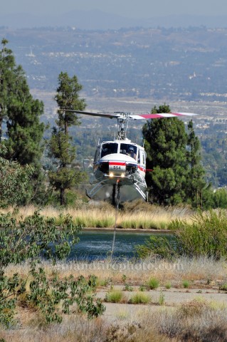
Helicopters: 4
Air Tankers: available
Air Attack: available
Road Closures: Hwy 18 closed between 40th Street in San Bernardino and Highway 138 near Crestline
Evacuations/Evacuations: voluntary evacuations for residents along Old Waterman Canyon Road
Weather: 100 degrees, winds 5mph SW
Terrain: steep and rugged
Cooperating Agencies: San Bernardino City Fire, CalFire, SB County Fire, San Manuel Fire, Rialto Fire, Crest Forest Fire, CHP, CalTrans, SB Sheriff’s Office
About the U.S. Forest Service, San Bernardino National Forest
The San Bernardino National Forest is comprised of three Ranger Districts spanning 676,666 acres in San Bernardino and Riverside counties. From the desert floor to the pristine mountain peaks, the San Bernardino National Forest offers natural environments, spectacular scenery, developed campgrounds and picnic areas, numerous recreational opportunities, and the solitude of quiet wilderness and open space for the over 24 million residents of Southern California and those visiting the area. The forest environment also provides habitat for numerous plants and animals and is crucial in sustaining drinking water, air, and soil quality. Learn more at [Click Here]
###
This electronic message contains information generated by the USDA solely for the intended recipients. Any unauthorized interception of this message or the use or disclosure of the information it contains may violate the law and subject the violator to civil or criminal penalties. If you believe you have received this message in error, please notify the sender and delete the email immediately.
Re: Panorama IC
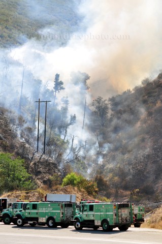
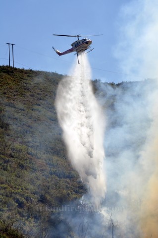
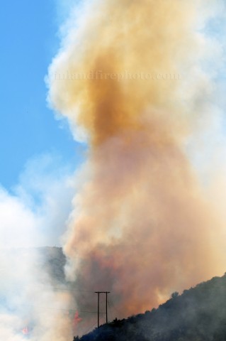
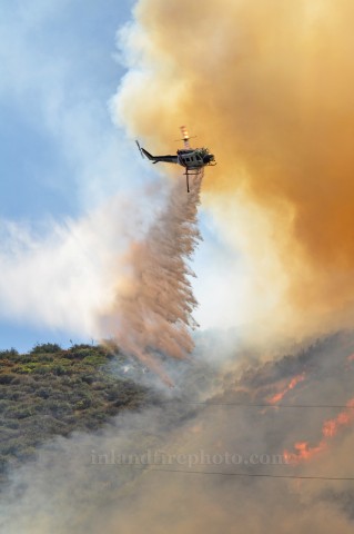
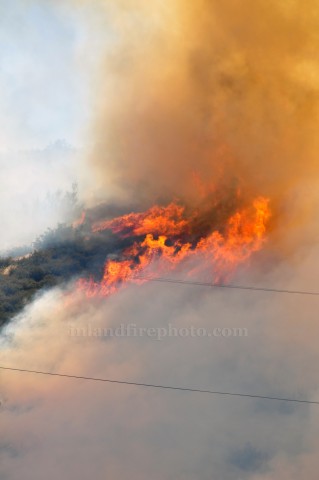
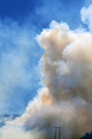
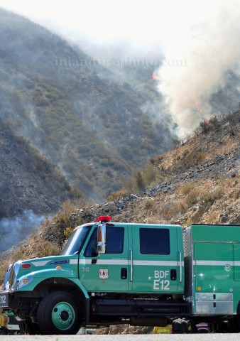
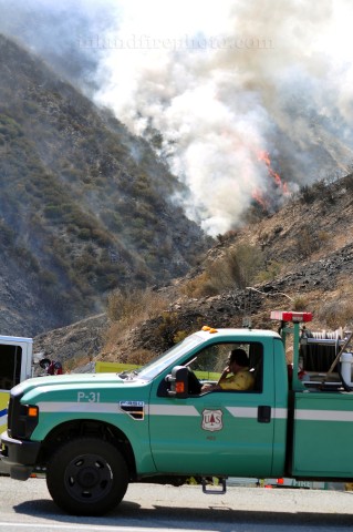
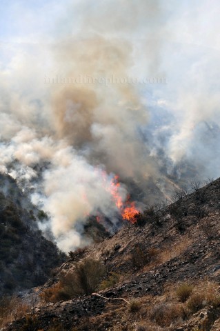
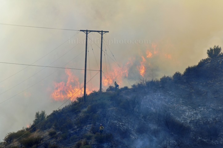
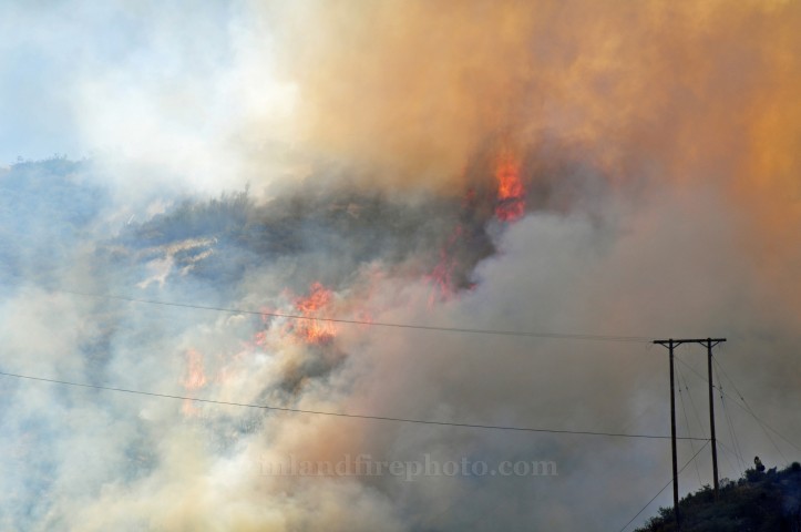
firephoto84, Mon Jul 09 2012, 07:59PM
Pictures from today's fire.


Re: Panorama IC
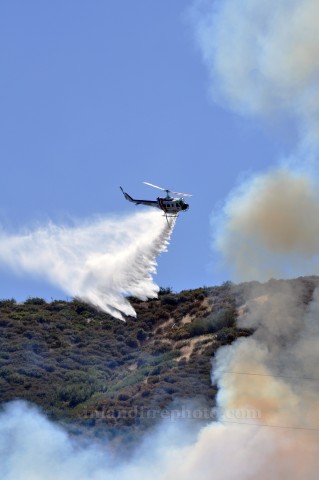
firephoto84, Mon Jul 09 2012, 08:00PM
Few more pictures.
Re: Panorama IC
SCM ALERT🚨, Mon Jul 09 2012, 08:35PM
Great Photos Cy! Thank you for giving us a good look at todays scary fire! Also, thank you firefighters!
Re: Panorama IC
Bookworm, Mon Jul 09 2012, 08:46PM
I have a question for Cy: How do you get so close to the fires. Do you have a press pass? What is the closest you are allowed to get to the actual fire?
Re: Panorama IC
firephoto84, Mon Jul 09 2012, 09:22PM
Yeah I have press passes. I can get right up to the fire's.
Re: Panorama IC
Rain, Mon Jul 09 2012, 10:53PM
fantastic shots firephoto thank you
ffs will be watching the fire tonite as its really not going anywere. winds are calm.
Re: Panorama IC
SCM ALERT🚨, Tue Jul 10 2012, 07:37AM
Panorama Fire is now 70% contained
State Highway 18 will remain closed until morning - Minor detour via Old Waterman Canyon Road.
Re: Panorama IC
SCM ALERT🚨, Tue Jul 10 2012, 07:26PM
PER SAN BERNARDINO NATIONAL FOREST TWITTER THE PANORAMA FIRE IS NOW 100% CONTAINED!
Re: Panorama IC
SCM ALERT🚨, Tue Jul 10 2012, 07:44PM
San Bernardino, Calif., July 10, 2012 – Firefighters have declared the Panorama fire 100% contained at 6:00p.m. on July 10th.
The Panorama fire was reported shortly before 2:00p.m. on July 9th along the west side of State Highway 18 north of Old Waterman Canyon Road. The fire quickly spread uphill towards Marshall Peak, swift and aggressive actions by firefighters held the fire to 75 acres.
At the height of the firefight, 263 firefighters from the US Forest Service, San Bernardino City Fire, CalFire, San Bernardino County Fire, San Manuel Fire, Rialto Fire, Crest Forest Fire and the Bureau of Land Management worked together suppressing the fire.
While battling the blaze on July 9, four firefighters suffered heat-related injuries and were transported to local area hospitals.
The fire was managed under unified command with the San Bernardino City Fire Department. Fire investigators have not determined a cause for the fire and are seeking the public’s assistance. Anyone with any information is encouraged to call Captain John Payan at San Bernardino City Fire Department 909-384-5777.
For more information please visit: [Click Here], or follow the San Bernardino National Forest on Twitter at [Click Here]
Quick Fire Facts:
Fire Start Date: 07/09/2012
Fire Report Time: 1:54 pm
Location: Waterman Canyon
Acres: 75
Fire Cause: Under Investigation – PLEASE CALL 909-384-5777 if you have any information
Fire Fighters Assigned: 263
Fire Engines: 23
Fire Crews: 6
Fire Dozers: 1
Helicopters: 5
Air Tankers: 4
Air Attack: 1
heyjude, Mon Jul 09 2012, 02:19PM
Vegetation fire onLower Waterman Canyon hwy 18. Request to shut hwy down, but have not decided where.
Re: Panorama IC
Rain, Mon Jul 09 2012, 02:43PM
scanner tac to listen is 168.200,also ffs are on waterman canyon road watching for spot fires= scanner
Re: Panorama IC
Rain, Mon Jul 09 2012, 02:47PM
air attack is working along the ridges ,also traffic along hwy 18 is being divirted to hwy 138 - chp log
Re: Panorama IC
Rain, Mon Jul 09 2012, 02:49PM
update on fire -bwt upper and lower waterman canyon,west of hwy 18 - may have started right in the turn out there, and then when up hill from there to the radio towers = scan
Re: Panorama IC
Rain, Mon Jul 09 2012, 02:51PM
fire is on * high gear north of hwy 18 per scanner
Re: Panorama IC
Rain, Mon Jul 09 2012, 03:00PM
hard closure on hwy 18 x hwy 138 /fire is bumping the road in several spots
hard closure at top top also .. = scanner
Re: Panorama IC
Bookworm, Mon Jul 09 2012, 03:09PM
Map [Click Here]
Re: Panorama IC
Rain, Mon Jul 09 2012, 03:12PM
ffs said its breezy not windy.. = scanner
Re: Panorama IC
Bookworm, Mon Jul 09 2012, 03:13PM
Webcam [Click Here]
Re: Panorama IC
Rain, Mon Jul 09 2012, 03:13PM
immediate need for strike team- strike team forming up at 40th street x waterman canyon road
=scanner
Re: Panorama IC
Bookworm, Mon Jul 09 2012, 03:19PM
Anyone who witnessed that start of the fire is requested to contact the Twin Peaks Fire Station. Lookling for a black van.
Re: Panorama IC
Bookworm, Mon Jul 09 2012, 03:21PM
Twitter: [Click Here]
Re: Panorama IC
Rain, Mon Jul 09 2012, 03:29PM
voluntary evaucations for the folks of waterman canyon are in progress. per
[Click Here]
Re: Panorama IC
Rain, Mon Jul 09 2012, 04:02PM
temp in devor area is 99 degrees
relative humidty - 11%
winds -south 9mph gusting to 14 mph
Re: Panorama IC
Rain, Mon Jul 09 2012, 04:16PM
fire is holding per fire photo 84 * ,
75 ac with a 10% containment
fire is only active in one section with smoke and flames seen other wise looking good per scanner
Re: Panorama IC
Rain, Mon Jul 09 2012, 04:17PM
fire moving to the westerly direction per eye wittenes down in this area
Re: Panorama IC
Rain, Mon Jul 09 2012, 04:42PM
nothing much going on over scanner but lite talk with air attack.. ( ffs are woking hard to get this fire contained)
Re: Panorama IC
Rain, Mon Jul 09 2012, 04:55PM
all air tankers have been releashed from this fire =scanner
Re: Panorama IC
Bookworm, Mon Jul 09 2012, 05:05PM
San Bernardino NF @SanBernardinoNF
Old Waterman Canyon Road is forecasted to open by 6:00 pm and the voluntary evacuations will be lifted at that time
Re: Panorama IC
heyjude, Mon Jul 09 2012, 07:01PM
Fire holding at 75ac with 30% containment. Per WLF
Re: Panorama IC
Lumber Jill, Mon Jul 09 2012, 07:07PM
FOR IMMEDIATE RELEASE Contact: Fire Information Center (909) 383-5688
Panorama Fire Burns 75 Acres in Waterman Canyon
San Bernardino, Calif., July 9, 2012 – Firefighters quickly responded to the report of a wildfire in Waterman Canyon on Monday afternoon. The Panorama Fire started at 1:54 pm and it burned 75 acres near Panorama Point on State Highway 18. It is currently at 30% containment.
263 firefighters from the US Forest Service, San Bernardino City Fire, CalFire, San Bernardino County Fire, San Manuel Fire, Rialto Fire, and Crest Forest Fire responded, taking immediate, aggressive and decisive actions to hold the fire to 75 acres. State Highway 18 was closed to all traffic from SR138 to 40th Street in San Bernardino during the duration of the fire. Motorists detoured on Hwy 330 or Hwy 138 from I-15 in the Cajon Pass.
Voluntary evacuations were in place for residents along Old Waterman Canyon Road. Old Waterman Canyon Road was re-opened at 6:15 p.m.
During the course of the firefight, three firefighters suffered heat-related injuries and were transported to local area hospitals.
The fire is under unified command with the San Bernardino City Fire Department. Fire investigators have not determined a cause for the fire and are seeking the public’s assistance. Anyone with any information is encouraged to call the San Bernardino City Fire Department at 909-384-5777.
“Firefighters did an excellent job today, considering the high temperatures and low humidity in Southern California today,” said District Ranger Gabe Garcia. “We want to remind the public to be extra cautious, and report any suspicious activity,” Ranger Garcia added.
For more information please visit us at [Click Here], call us at 909-383-5688 or follow us on Twitter at [Click Here]
Quick Fire Facts:
Fire Start Date: 07/09/2012
Fire Report Time: 1:54 pm
Location: Waterman Canyon
Acres: 75
Fire Cause: Under Investigation – PLEASE CALL 909-384-5777 if you have any information
Fire Fighters Assigned: 263
Fire Engines: 23
Fire Crews: 6
Fire Dozers: 0
Helicopters: 4
Air Tankers: available
Air Attack: available
Road Closures: Hwy 18 closed between 40th Street in San Bernardino and Highway 138 near Crestline
Evacuations/Evacuations: voluntary evacuations for residents along Old Waterman Canyon Road
Weather: 100 degrees, winds 5mph SW
Terrain: steep and rugged
Cooperating Agencies: San Bernardino City Fire, CalFire, SB County Fire, San Manuel Fire, Rialto Fire, Crest Forest Fire, CHP, CalTrans, SB Sheriff’s Office
About the U.S. Forest Service, San Bernardino National Forest
The San Bernardino National Forest is comprised of three Ranger Districts spanning 676,666 acres in San Bernardino and Riverside counties. From the desert floor to the pristine mountain peaks, the San Bernardino National Forest offers natural environments, spectacular scenery, developed campgrounds and picnic areas, numerous recreational opportunities, and the solitude of quiet wilderness and open space for the over 24 million residents of Southern California and those visiting the area. The forest environment also provides habitat for numerous plants and animals and is crucial in sustaining drinking water, air, and soil quality. Learn more at [Click Here]
###
This electronic message contains information generated by the USDA solely for the intended recipients. Any unauthorized interception of this message or the use or disclosure of the information it contains may violate the law and subject the violator to civil or criminal penalties. If you believe you have received this message in error, please notify the sender and delete the email immediately.
Re: Panorama IC
firephoto84, Mon Jul 09 2012, 07:59PM
Pictures from today's fire.


Re: Panorama IC
firephoto84, Mon Jul 09 2012, 08:00PM
Few more pictures.


Re: Panorama IC
SCM ALERT🚨, Mon Jul 09 2012, 08:35PM
Great Photos Cy! Thank you for giving us a good look at todays scary fire! Also, thank you firefighters!
Re: Panorama IC
Bookworm, Mon Jul 09 2012, 08:46PM
I have a question for Cy: How do you get so close to the fires. Do you have a press pass? What is the closest you are allowed to get to the actual fire?
Re: Panorama IC
firephoto84, Mon Jul 09 2012, 09:22PM
Bookworm wrote ...
I have a question for Cy: How do you get so close to the fires. Do you have a press pass? What is the closest you are allowed to get to the actual fire?
I have a question for Cy: How do you get so close to the fires. Do you have a press pass? What is the closest you are allowed to get to the actual fire?
Yeah I have press passes. I can get right up to the fire's.
Re: Panorama IC
Rain, Mon Jul 09 2012, 10:53PM
fantastic shots firephoto thank you
ffs will be watching the fire tonite as its really not going anywere. winds are calm.
Re: Panorama IC
SCM ALERT🚨, Tue Jul 10 2012, 07:37AM
Panorama Fire is now 70% contained
State Highway 18 will remain closed until morning - Minor detour via Old Waterman Canyon Road.
Re: Panorama IC
SCM ALERT🚨, Tue Jul 10 2012, 07:26PM
PER SAN BERNARDINO NATIONAL FOREST TWITTER THE PANORAMA FIRE IS NOW 100% CONTAINED!
Re: Panorama IC
SCM ALERT🚨, Tue Jul 10 2012, 07:44PM
San Bernardino, Calif., July 10, 2012 – Firefighters have declared the Panorama fire 100% contained at 6:00p.m. on July 10th.
The Panorama fire was reported shortly before 2:00p.m. on July 9th along the west side of State Highway 18 north of Old Waterman Canyon Road. The fire quickly spread uphill towards Marshall Peak, swift and aggressive actions by firefighters held the fire to 75 acres.
At the height of the firefight, 263 firefighters from the US Forest Service, San Bernardino City Fire, CalFire, San Bernardino County Fire, San Manuel Fire, Rialto Fire, Crest Forest Fire and the Bureau of Land Management worked together suppressing the fire.
While battling the blaze on July 9, four firefighters suffered heat-related injuries and were transported to local area hospitals.
The fire was managed under unified command with the San Bernardino City Fire Department. Fire investigators have not determined a cause for the fire and are seeking the public’s assistance. Anyone with any information is encouraged to call Captain John Payan at San Bernardino City Fire Department 909-384-5777.
For more information please visit: [Click Here], or follow the San Bernardino National Forest on Twitter at [Click Here]
Quick Fire Facts:
Fire Start Date: 07/09/2012
Fire Report Time: 1:54 pm
Location: Waterman Canyon
Acres: 75
Fire Cause: Under Investigation – PLEASE CALL 909-384-5777 if you have any information
Fire Fighters Assigned: 263
Fire Engines: 23
Fire Crews: 6
Fire Dozers: 1
Helicopters: 5
Air Tankers: 4
Air Attack: 1